A Walk Down Memory Lane...
Once again I find myself sitting here reminiscing about my brief time in the Southern Appalachians. Grandfather Mountain was always a good time, the dozens of waterfalls visited were always relaxing, the Rhododendron bloom in the Roan Highlands were a wonder to behold. Amongst all these trips, each memorable in their own right, one stands out in my memory.
This hike took place on a particularly breezy day in mid-October 2006. I don't remember the exact circumstances surrounding the trip but I do know my wife wasn't real happy about my making a third trip north to Grayson Highlands in as many weeks. Peak color in the High Country is a fleeting thing, though...
My route took me from Massie Gap to the top of Rogers via the open ledges of Wilburn Ridge. The day was clear and
almost perfect...the winds were literally breathtaking. On numerous occasions I actually had to take a knee to steady my camera enough for a photo. If anything, it made the trip even more memorable...
Wind, Ponies, Poo, & more Wind...
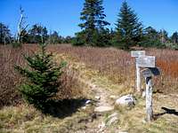
![The Ridge Bekons...]() Massie Gap Trailhead
Massie Gap Trailhead![Joining the AT...]() Appalachian Trail
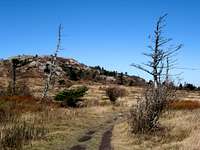
Appalachian Trail![Ghost Forest...]() Tree Skeletons
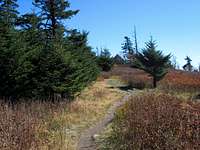
Tree Skeletons![Wilburn Ridge Trail]() Onto Wilburn Ridge
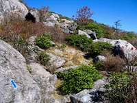
Onto Wilburn Ridge![Rock & Ash]() Rock & Ash
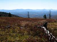
Rock & AshIn places the Wilburn Ridge felt more like a high western prairie than southwest Virginia...5300' |
This is the view I was treated to from the first crest you pass over on Wilburn Ridge.
Mt. Rogers is visible to the left of the rocky peak in the center...5350' |
![Wilburn Ridge Outcrop]() Rock Outcrop
Rock Outcrop![Blazes on the Rocks...]() Blazes
Blazes![Field, Rock, Field, Rock...]() Fields & Rocks
Fields & RocksOn numerous occasions I found myself thinking..."Does it get any better than this?!?!" |
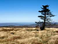
![Lone Pine]() Lone Pine
Lone Pine![Rhododendron Gap]() Rhododendron Gap
Rhododendron Gap![Whitetop Mountain]() Whitetop Mt.
Whitetop Mt.As I approached Thomas Knob Shelter Mt. Rogers began to take center stage on the horizon...5400' |
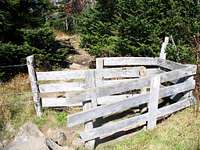
![Cattle Gate...]() Cattle Gap
Cattle Gap![Lewis Fork Wilderness]() Lewis Fork Wilderness
Lewis Fork Wilderness![Mt. Rogers Summit Spur]() Summit Spur
Summit Spur![Mt. Rogers Summit]() Rogers Summit
Rogers Summit![Mt. Rogers Benchmark]() Benchmark
Benchmark![Spruce Fir Forest]() Spruce-Fir Forest
Spruce-Fir ForestSensory overload was a serious problem along the AT on the way back to Thomas Knob...5400' |
![Mt. Rogers Landmine]() Landmines
Landmines![Approaching Thomas Knob Shelter]() Smoke, Anyone?
Smoke, Anyone?![Endless Mountains]() Endless Mountains
Endless Mountains![Fenceline]() Fencelines
FencelinesI was having mixed feelings about crossing Wilburn Ridge again. No doubt the scenery was amazing but I felt I
was developing some serious windburn and the next few miles weren't going to help it any...5450' |
![Peaceful Trail]() Peace
PeaceThis was the stunning panorama from a rock outcrop above Rhododendron Gap. Mt. Rogers rises to the left above the Lewis Fork Valley below...5500' |
![High Country Fall Color]() Fall color
Fall colorLooking down on Rhododendron Gap from a nearby rock outcrop...5500' |
![Rock Outcrop on Wilburn Ridge]() Wilburn Rocks
Wilburn Rocks![Appalachian Trail on Wilburn Ridge]() Busy Trail
Busy TrailThere's no way to express how breathtaking the winds were on this day...it's amazing any of these panoramic shots turned out! |
The sweeping view to the south of North Carolina's High Country from Wilburn Ridge |
As I dropped off the open ridge I was anxious to get out of the wind but, oh, was I going to miss the views! |
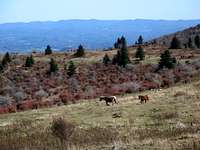
![Rangeland]() Rangeland
Rangeland![No Free Lunch]() Beggar
BeggarThe last grassy area I come to before descending to Massie Gap has been designated
a bird sanctuary and one is asked to kindly stay on the trail...4875' |
![Descending to Massie]() Back to Massie
Back to Massie


Comments
Post a Comment