Magical Blue Lakes Basin
To say that Blue Lakes Basin is stunning would be an understatement. Alpine lakes, peaks jutting up over 2,000 feet right in front of you, a cirque of peaks where you can feel the closeness, with Mount Sneffels to the east and the formidable Dallas Peak to the south. When you arrive here you know that you have two options if you want to keep hiking; retreat to the trailhead or start moving forward vertically.
Blue Lakes Basin is a special place and it now ranks very high on the list of my favorite places I have visited in Colorado. I realize that I should keep quiet about such gems, but I’ll let you in on what is not a well kept secret, and that would be Blue Lakes Basin. By the time we made it to the basin we had already spent four days in Colorado and everyone we had talked to, in town or on the trail, seemed to know about Blue Lakes. Even more telling were the smiles that appeared on their faces and the inflection in their voices when they started talking about Blue Lakes. That should have given us a clue that this was a magical place. But I already had a good idea of that just from the pictures I saw when planning this trip. I had read several comments that the area was very popular. As everyone we talked to seemed to know about Blue Lakes, this only confirmed my suspicion. Add in the facts that the trailhead is pretty accessible, being about 15 miles from Ridgeway with a dirt access road that any vehicle can easily negotiate, there is easy access to a 14er, and it’s stunningly beautiful. Yeah, I would imagine it could be busy. In pictures it looked beautiful and that was why I decided to include it on our itinerary. Mount Sneffels gave us a great peak to go after, but it was Blue Lakes Basin that was the real draw.
Rob, Andrew and I spent the first three days of our trip in
Ice Lake Basin and after leaving there on Tuesday afternoon we camped at the Amphitheater that evening in Ouray. Being the creature of habit that I am, on Wednesday morning we stopped in Ouray again for the $9.99 all you can eat breakfast before making the drive to the trailhead.
It had rained most of the day on Tuesday and the rain had cleared out by Wednesday morning but there were still plenty of low lying clouds which would unfortunately block our view of the mountains most of the day. Apparently there were supposed to be excellent views of Mount Sneffels on portions of the Blue Lakes Trail, but we were only able to get a few teaser views on the entire hike in.
![Mount Sneffels]() Our first view of Mount Sneffels
Our first view of Mount Sneffels![The Peaks of Blue Lakes Basin]() A cloud covered Blue Lakes Basin
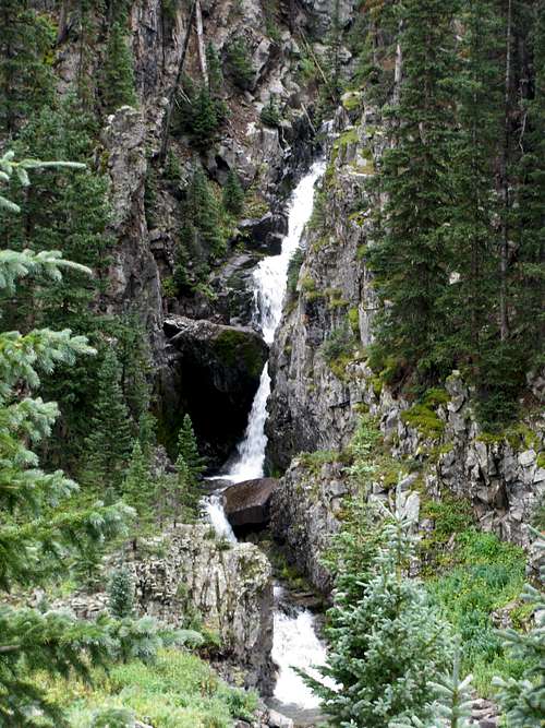
A cloud covered Blue Lakes Basin![Falls Near Blue Lakes Trail]() Falls on Blue Lakes Trail
Falls on Blue Lakes Trail![Peaks South of Lower Blue Lake]() At Lower Blue Lake
At Lower Blue Lake
I’m sure on weekends the area is busy. But with it being the middle of the week and early in September, it was pretty quiet. When we arrived at the trailhead there were only four other vehicles there and by the time we reached the lake I figured out that they all belonged to dayhikers. We would end up having the whole basin to ourselves on Wednesday night and there was only one other tent set up on Thursday night and it was far away from us at the south end of the lake.
One observation; from watching the few people that did show up to the basin, I got the impression that very few people venture above the lower lake. Anyone willing to hike a little higher shouldn’t have too hard of a time getting away from crowds.
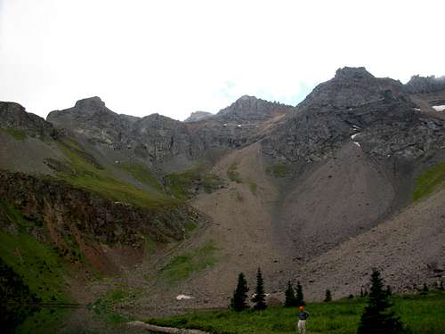
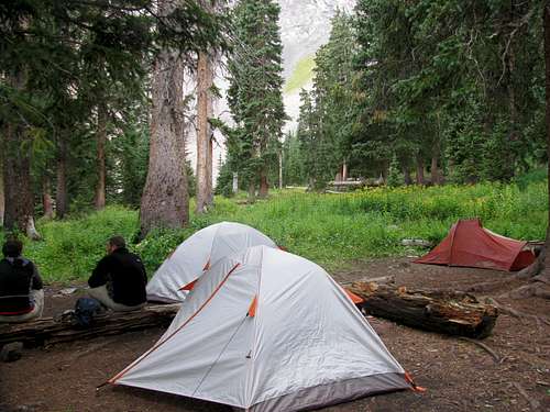
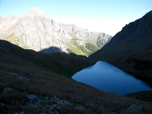
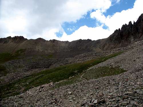
From trailhead to the basin it is just 3.3 miles with 1600 feet of elevation gain so we made it there pretty quickly. We set up camp in the woods behind Lower Blue Lake and it was still early enough that we could get a hike in before dark. On Friday we were planning on climbing one of the 13ers in the upper basin that is west of the lakes so I wanted to make a short trip up there to scope it out.
I didn’t have a lot of good beta on the
route so we were sort of winging it. We hiked to the south end of Lower Blue Lake to an inlet stream and stayed fairly close to it as we headed up. There were hardly any trees so we didn’t have to bushwhack and it was easy to see ahead of us. The terrain was mostly grass and was definitely steep which wasn’t too much of an issue going up but was pretty slippery on the way down. After a little over an hour we made it up to the front of a long ridge that looks like a shark’s fin and splits the upper basin.
![Cascades on Lower Blue Lake Inlet Stream]() Inlet stream at the south end of Lower Blue Lake
Inlet stream at the south end of Lower Blue Lake![Lower Blue Lake]() Lower Blue Lake from the west
Lower Blue Lake from the west![Shark s Fin]() The "shark's fin"
The "shark's fin"
We were about 1,000 feet above the lake at this time and got another teaser view of Sneffels in the clouds. At this point we turned around and headed down and made it back in just enough time to eat dinner in daylight and then head to bed.
![Mount Sneffels]() Mount Sneffels and hopes for clearer weather on Thursday
Mount Sneffels and hopes for clearer weather on ThursdayTour de Sneffels
Thursday was the big day for this portion of the trip. If the weather cooperated we would try climbing Mount Sneffels via the Class 3 southwest ridge route. When I crawled into my tent I wasn’t very optimistic about the weather. It had been overcast for the past 48 hours and even though I loved the scenery in Blue Lakes Basin, all day the clouds had been hanging low enough to block most ridgeline views. In the middle of the night I noticed it had gotten noticeably colder. I was hoping that this meant the clouds had cleared. I poked my head out of the tent around 2 AM, looked up and saw nothing but stars.
When I rolled out of the tent in the morning the sky was still crystal clear. Despite the good weather we should have gotten an earlier start as it was around 7 AM before we started up towards Blue Lakes Pass. The late start wouldn’t cause us a problem, other than a quicker descent from the summit than we wanted, but again starting an hour or two earlier would have been prudent.
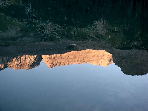
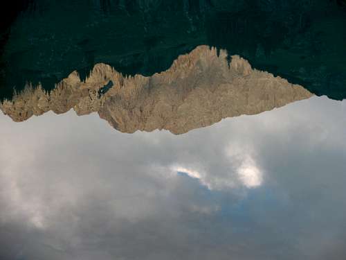
![West Dallas Peak Reflection]() West Dallas Peak reflected in Lower Blue Lake
West Dallas Peak reflected in Lower Blue Lake
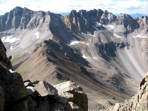
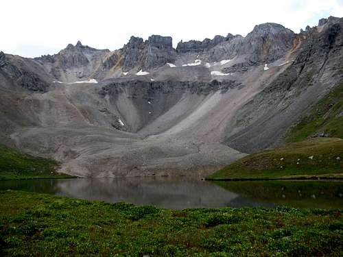
The hike to the pass was wonderful with lots of great eye candy as we passed each of the Blue Lakes. We had clear skies all morning which resulted in impeccable views of the peaks in the west basin.
![Lower Blue Lake]() Lower Blue Lake
Lower Blue Lake![Middle Blue Lake]() Middle Blue Lake and S4
Middle Blue Lake and S4![Upper Blue Lake]() Upper Blue Lake
Upper Blue Lake
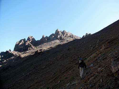
Things started getting a little more strenuous as we made our way up the switchbacks to the pass, and once we got above the grass on the switchbacks we started to get better glimpses of what was to come; pinnacles and loose rock. When we reached Blue Lakes Pass we took a short break, donned our helmets, and started up the southwest ridge.
![Blue Lakes Pass Switchbacks]() Switchbacks to Blue Lakes Pass
Switchbacks to Blue Lakes Pass![Blue Lakes Pass Switchbacks]() High up on the switchbacks
High up on the switchbacks![Approaching Blue Lakes Pass]() Approaching Blue Lakes Pass with the route in view
Approaching Blue Lakes Pass with the route in view![Mount Sneffels Southwest Ridge]() Looking at the route from Blue Lakes Pass
Looking at the route from Blue Lakes Pass![The View West From Blue Lakes Pass]() View west from Blue Lakes Pass. L to R: Dallas Peak, West Dallas Peak, T0, S3, S5 & S4
View west from Blue Lakes Pass. L to R: Dallas Peak, West Dallas Peak, T0, S3, S5 & S4
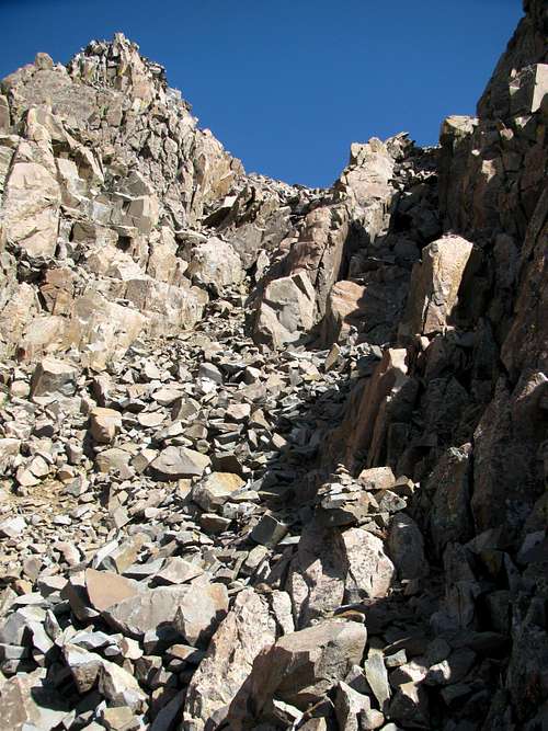
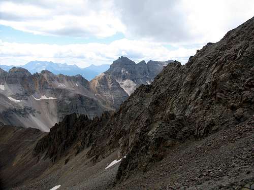
I will confess to being a little nervous about the southwest ridge route. I wasn’t concerned with how physically challenging it might be or about the exposure on the ridge crest. No, as my route finding skills are not my strongest suit, my only concern was with finding our way through the pinnacles and gullies of the southwest ridge. Unlike most of the peaks I have been on in Colorado, I figured the route finding on the southwest ridge wouldn’t be a slam dunk and I was correct. This would not be a walk up! It was easy to see that picking the wrong gully could make for a long day of backtracking and more than likely lead to terrain more difficult than Class 3.
![Don t Pick the Wrong Gully]() Which gully is it? "You must choose. But choose wisely..."
Which gully is it? "You must choose. But choose wisely..."
I had studied the route thoroughly prior to the trip but I knew that once we got above the pass that a lot of these gullies would all start to look alike to me, and I was right. More concerning to me was being able to locate the correct exit point from each gully. I had read that the route is well cairned but I wasn’t going to trust that and I am glad I didn’t as “well cairned” is a relative term. Yes, there were quite a few cairns along the route and some were quite helpful. Others were in some rather strange spots that only confused us. There was one right at a fork in a gully, and both the left and right fork appeared to lead to a possible exit point of the gully. One did. One didn’t! Because of this we spent more time than we are accustomed to evaluating which path to take. While other peaks I have climbed may have been more physically challenging for me, Sneffels ended up being the most mentally taxing.
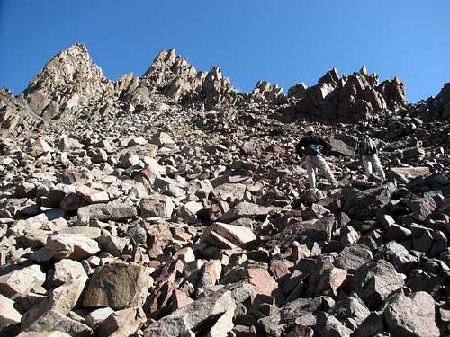
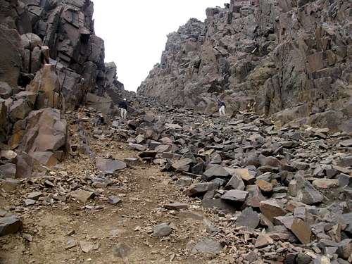
I call them gullies, and there seemed to be two major ones on the route before popping out onto the ridge crest. We made it up the first gully without any problems. We had to take our time on a couple of occasions to make sure we were heading the correct direction, but overall it was not too complicated.
![Initial Gully on Mount Sneffels Southwest Ridge]() This would be the correct gully!
This would be the correct gully!![Mount Sneffels Southwest Ridge]() Rob and Andrew making their way up
Rob and Andrew making their way up![Initial Gully on Mount Sneffels Southwest Ridge]() High up in the first gully
High up in the first gully![Blue Lakes Pass]() Gilpin Peak (left) and Blue Lakes Basin (right) from the first gully
Gilpin Peak (left) and Blue Lakes Basin (right) from the first gully
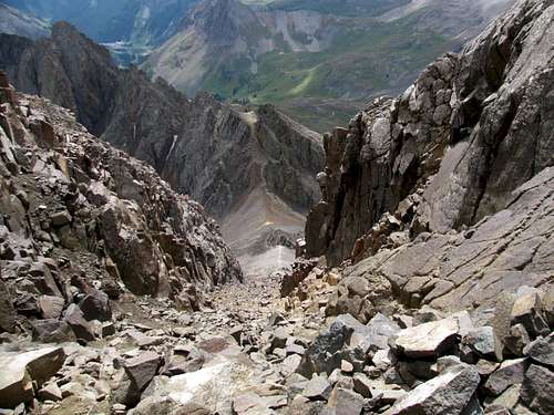
When we climbed through the notch at the top of the first gully we did some head scratching. There is a (another) short gully that drops quite a ways before you make a left hand turn which will lead you up into what I refer to as the second gully. My notes said we only had to drop about 30 feet. I had no interest in dropping all the way down to reach that gully. After surveying the landscape we saw a few cairns that led us across a “ledge”. Again, some of the cairns were a little confusing but after taking a closer look at where we needed to head we quickly made it across the ledge to the second gully. And what a long steep gully it would be!
![The Drop From the Notch]() From the notch, looking down the short drop to the second gully. The ledge we used to avoid dropping all the way down is to the left.
From the notch, looking down the short drop to the second gully. The ledge we used to avoid dropping all the way down is to the left.![Mount Sneffels 2nd Gully]() Looking over to the second gully from the notch
Looking over to the second gully from the notch![Blue Lakes Basin]() Blue Lakes Basin from the second gully
Blue Lakes Basin from the second gully
The crux of the route ended up being a Class 3 move in the second gully. It was probably about only head high but it did require good foot placement. Unfortunately there was a slow stream of water running right over where we needed to place our feet. This made things slicker and a little trickier than I liked. It took a little while but eventually we all made it up.
Of course by the time we were high up in the second gully clouds started to roll in. A gentle reminder that monsoon season wasn’t quite over yet!
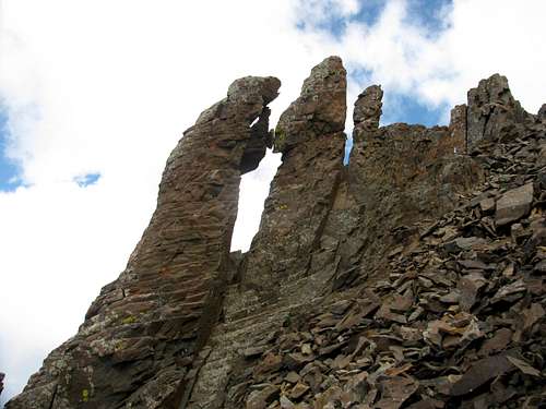
Seeing the “Kissing Camels” was a big relief. At that point I not only knew we were on the right track but we were also extremely close to the ridge crest and after that the route finding concerns should be over.
![The Kissing Camels]() The "Kissing Camels"
The "Kissing Camels"![Mount Sneffels 2nd Gully]() Looking down the second gully from near the kissing camels
Looking down the second gully from near the kissing camels![Mount Sneffels 2nd Gully]() Exit of the second gully at the V notch
Exit of the second gully at the V notch![View From Mount Sneffels Southwest Ridge]() Finally out on the ridge
Finally out on the ridge
When we popped out onto the ridge crest there was one small rock tower we needed to get up and around. It probably didn’t require any more than 20 feet of scrambling to get up but getting around this “rock” was like playing a game of
Let's Make a Deal. In the end we found three short gullies that would lead us up this rock to the ridge crest. So do you pick gully number 1, number 2 or number 3? I bypassed gully number one as it looked too steep and loose. So I went to gully number two and bypassed it as it looked too steep and loose. When I got to gully number three it looked too steep and loose as well but I decided to give it a try. I started up and after a few steps I sent a hand full of large rocks downhill so I reconsidered. Rob was back by gully number two and had scoped it out and that ended up being the better choice. It ended up being an easy scramble up.
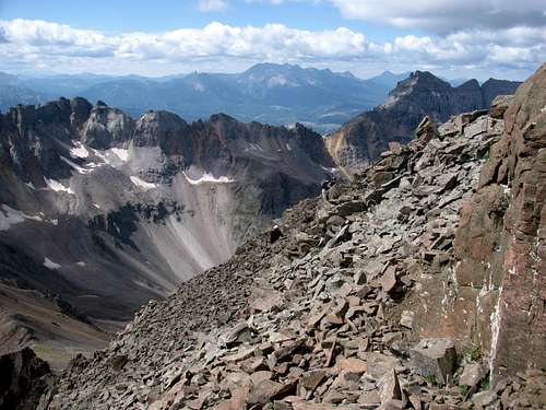
![High on the Southwest Ridge]() Rob and Andrew out on the ridge
Rob and Andrew out on the ridge![High on the Southwest Ridge]() A fun day of scrambling!
A fun day of scrambling!
Once above this rock we were just below the ridge crest and ironically it would be here that I made my only real route finding mistake of the day. We could see the summit and we started angling up towards it. But instead of angling for it we should have climbed directly to the ridge crest. I don’t know if I figured there was a false summit or what, but I ended up taking us all the way across the face of Sneffels. Before I knew it we were near the v notch for the descent of Lavender Col. So after climbing the southwest ridge nearly to the summit we ended up finishing the last 100 vertical feet on the standard route. Go figure!
![Oops!]() Oops! Finishing on the standard route
Oops! Finishing on the standard route
As seems to be our luck, about the time we reached the top low lying clouds started to roll in so we ended up spending about 10 minutes total on the summit. We snapped a few summit pics and started heading down. Right before we climbed through the v notch we met the first and only person we would see all day. Just like on Snowmass last year, today we had the climb and summit of Sneffels all to ourselves!
![Mount Sneffels Summit View]() Blue Lakes Basin
Blue Lakes Basin![]()
![]() The View From the Summit of Mount Sneffels The View From the Summit of Mount Sneffels |
We did decide to do the Tour de Sneffels and descend the standard route. Getting down Lavender Col was simple enough but the descent down the scree slope was frustrating. We slid and slipped all the way down. I have yet to learn the art of screeing! I was never so glad to get down to the trail junction that would take us back to Blue Lakes Pass.
![Lavender Col]() Lavender Col
Lavender Col![Lavender Col]() A loose descent in Lavender Col
A loose descent in Lavender Col![View From Lavender Col]() Peaks of Yankee Boy Basin from Lavender Col
Peaks of Yankee Boy Basin from Lavender Col![View From Lavender Col]() Peaks of Yankee Boy Basin from the bottom of Lavender Col
Peaks of Yankee Boy Basin from the bottom of Lavender Col![Dallas Peak]() Dallas Peak from the scree slope
Dallas Peak from the scree slope
At the junction we took a short break before heading up to the pass. I took the back of the line and admittedly struggled getting up to the pass. Sneffels took more out of me than I thought and I plodded my way back to the pass.
![Blue Lakes Pass]() Blue Lakes Pass from Yankee Boy Basin
Blue Lakes Pass from Yankee Boy Basin![Gilpin Peak]() Gilpin Peak
Gilpin Peak![The Scree Slope]() Good ridance to the scree slope!
Good ridance to the scree slope!![Mount Sneffels Southwest Ridge]() Blue Lakes Pass and Sneffels' southwest ridge
Blue Lakes Pass and Sneffels' southwest ridge
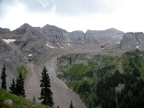
We still had plenty of good scenery to enjoy on our hike down from the pass to our campsite.
![Blue Lakes Pass Switchbacks]() A San Juan rock glacier
A San Juan rock glacier![Upper Blue Lake]() Block Tops and Upper Blue Lake
Block Tops and Upper Blue Lake![S4 and Middle Blue Lake]() S4 and Middle Blue Lake
S4 and Middle Blue Lake![Dallas Peak and West Dallas Peak]() Dallas Peak and West Dallas Peak
Dallas Peak and West Dallas Peak
We made our way back to camp and celebrated our wonderful day on Sneffels by going to bed fairly early. I guess I should have packed in another one of those
Expedition Stouts for an evening celebration!
![Mount Sneffels Reflection]() Mount Sneffels reflected in Lower Blue Lake
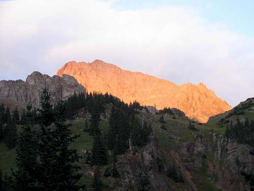
Mount Sneffels reflected in Lower Blue Lake![Alpenglow on Mount Sneffels]() Alpenglow on Mount Sneffels
Alpenglow on Mount SneffelsHeading West Then East
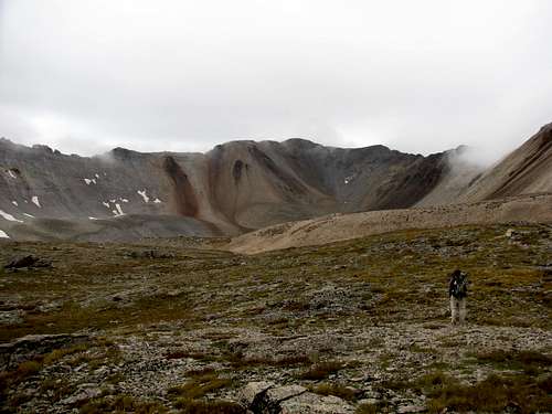
Friday was our last day in Colorado and I didn’t want to just get up, break down camp and hike out. The plan was to try and bag one of the 13ers in the upper basin west of the lake. Andrew was content with having bagged Sneffels and stayed at camp, so Rob and I got up early and headed up.
![Blue Lakes Basin Sunrise]() Sunrise from the west basin
Sunrise from the west basin
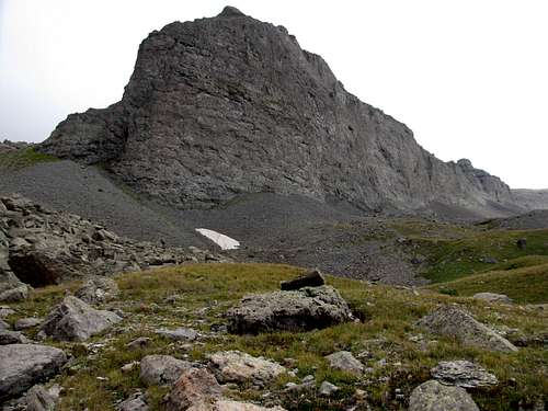
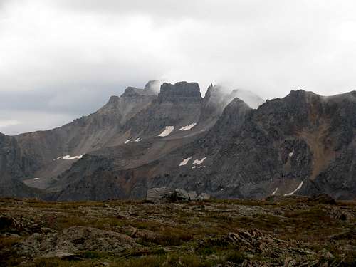
It was a little slower going this morning than I hoped. I really wanted to go for a summit but after five straight days of hiking my heart and more so my legs were not up for it. We were able to make it all the way up into the basin where we had an excellent view of the five 13ers we could consider bagging from here. But again, our legs and hearts were not into it.
![Feeling Small]() High in the basin
High in the basin![The Upper Basin West of Blue Lakes]() Near the top of the basin
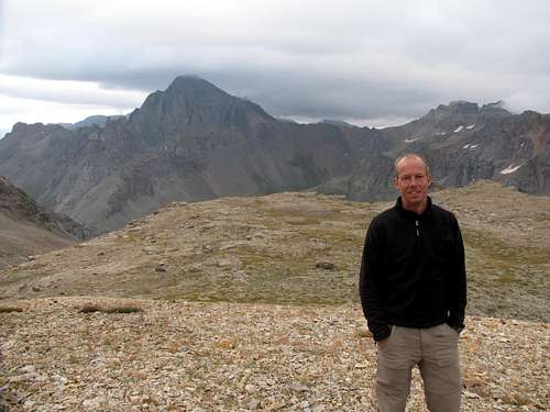
Near the top of the basin![T0]() Rob looking towards T0 and a barren landscape
Rob looking towards T0 and a barren landscape![S3 and S5]() S3 and S5
S3 and S5
We considered hiking to one of the saddles and I thought one of the two S5 saddles looked the most inviting. As we stood there the weather did the choosing for us. It started snowing and what seemed rather strange, the weather seemed to be coming in from the east as opposed to the west.
![Storm From the East]() Storm coming in from the east
Storm coming in from the east
We also noticed that there was extensive cloud cover on Mount Sneffels. We couldn’t help but think that we were so fortunate to have climbed Sneffels on Thursday. Today would not have been the day as she was covered in clouds! We snapped a few pictures and realized it was time to start heading home.
![Mount Sneffels]() Time to head home
Time to head home
We headed back down to Lower Blue Lake, broke camp and made the short hike out. We were on the road heading back to Indiana just after noon. It would be another long 22 hour drive home and another long 11 months before heading back west. The wheels on the Tribute were spinning for home and the wheels in my head were spinning as well, thinking about where our adventures west in August 2012 will take us.


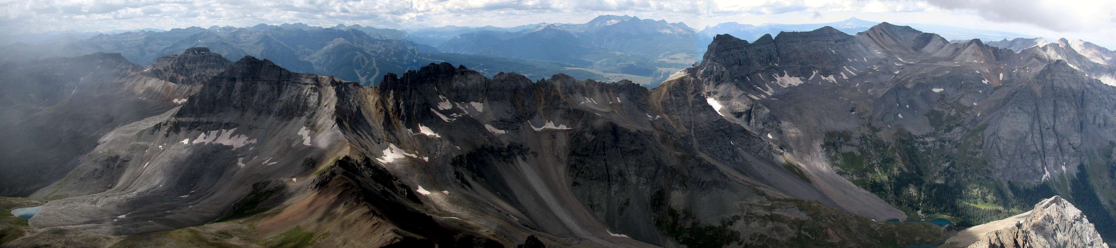
 The View From the Summit of Mount Sneffels


Comments
Post a Comment