
-
 224814 Hits
-
 99.82% Score
-
 143 Votes
|
|
Mountain/Rock |
|---|---|
|
|
38.00330°N / 107.792°W |
|
|
Hiking, Mountaineering, Ice Climbing, Mixed, Scrambling, Skiing |
|
|
Spring, Summer, Fall, Winter |
|
|
14150 ft / 4313 m |
|
|
Overview
This page was transferred to me by Aaron Johnson, where he is credited for some of the original formatting. I am respecting his wishes to re-write this page and include a new set of photos...thanks
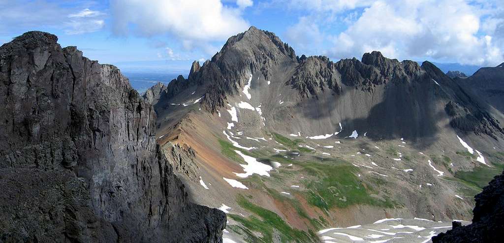
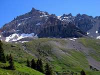
Sneffels is often said to be Colorado's best and most beautiful mountain. Viewed from Dallas Divide, Mount Sneffels really looks like a "mountain" and has all the good features of one including symmetry, spires, pinnacles, rugged ridges and beautiful slopes of aspens and flowers. Mountaineers cringe at the climbing possibilities, Nature enthusiasts glory at its beauty and generic travelers are awed upon viewing this gorgeous mountain. Second in elevation only to Uncompahgre Peak in the San Juan range, Sneffels is affectionately known as the “Queen of the San Juans.” You will find photos of Mount Sneffels in stores, calenders, postcards and wallets! (Yes, I have a photo of it in mine). Sneffels has also made appearances in a number of westerns, notably “How the West was Won,” and more notably, in “True Grit,” where it is seen in flattering vistas from Dallas Divide. Next to the Maroon Bells, Sneffels is Colorado’s most recognizable mountain. Mount Sneffels brings together all types of climbers from the beginner hiker to the expert mountaineer. A large variety of routes exist on Sneffels making this one of the favored mountains in Colorado.
  |
Getting There
To get to Sneffels you must drive to Ouray which is 47 miles south of Montrose on Highway 550
YANKEE BOY BASIN ACCESS
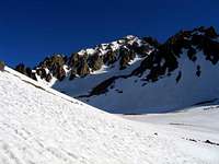
Continuing south from Ouray on the highway, continue up and around the first major switchback and turn right into County Road 361 with signs for Yankee Boy Basin. Head up this steep but well graded road for 6.5 miles and stay right at the Camp Bird road junction. Winter maintence usually ends here. The steep cliffs and shelf section are spectacular yet scary for some people. There is a short stretch of shelf road just past the Camp Bird junction that was carved into the cliff side during the mining days. In the spring a waterfall often cascades over the road here making for a real sight to see and one strange drive! This dramatic stretch is just wide enough for one vehicle. Consider the road's condition and your comfort before proceeding.
It is a good idea to have 4WD beyond the Camp Bird entrance. In my experience driving this road, 2WD cars get held up on a fairly steep and loose section just before the dramatic shelf. All wheel drive cars or passenger cars with decent clearance can make the road up into Yankee Boy Basin when dry. Pass the Imogene Pass junction and at 10,800 feet, the Governor Basin Road heads off to the left (at a large mine). A high clearance 4WD vehicle is required beyond this point. I was able to get my Toyota Camry this far in 2012. With a 4WD, continue up to the right at the Governor Basin junction and park where you feel that you are well off the road and off private property. There is a vault toilet facility 0.8 miles past the Governor Basin junction at 11,300 feet. At this small bathroom there is room for many vehicles and this is probably the most popular parking spot. Beyond the small bathroom, a rougher 4WD trail heads further into the basin to treeline where it basically turns into the trail towards Blue Lakes Pass.
2012 Update: The Yankee Boy basin Road will open May 1st each year from this point forward...regardless of whether it's clear of snow or not. Prior to this date, the road is closed at the gate at 9,100 feet elevation.
 Yankee Boy Basin Yankee Boy Basin |
 Yankee Boy Road Yankee Boy Road |
 Sneffles SW Ridge Sneffles SW Ridge |
 Yankee Boy Basin Yankee Boy Basin |
BLUE LAKES/BLAINE BASIN via EAST DALLAS ROAD ACCESS
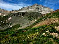
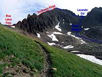
Drive to Ridgeway which is located on Highway 550 between Montrose and Ouray. Head west 4.7 miles on Colorado Highway 62 (Road towards Telluride) to the East Dallas Creek National Forest access road and turn south. This road is very well signed and in great shape all the way to its end. Mt. Sneffels seems to grow in size and dominate you view as you get nearer. The Blaine Basin and Blue Lakes trails begin here. The Blue Lakes trail is a stunning hike and Blue Lake may be one of Colorado's finest lakes with its bright blue color. The trail then continues up to the upper two lakes and eventually reaches Blue Lakes Pass connecting to the Yankee Boy Basin.
The wildflower displays on this hike are top notch...bring your camera! The South Ridge 3rd Class route on Sneffels starts from the pass. For the standard Lavender Couloir route, follow the trail down through several switchbacks until you see the obvious wide gully to the north. The Blaine Basin trail starts from this same trailhead and heads further east and up the valley to the east of Sneffels. This approach is used mainly for the technical north face routes however one can climb up to the Sneffels/Kismet saddle up very steep and loose talus (or snow in the right season) and meet with the standard Lavender Couloir route.
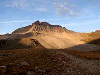
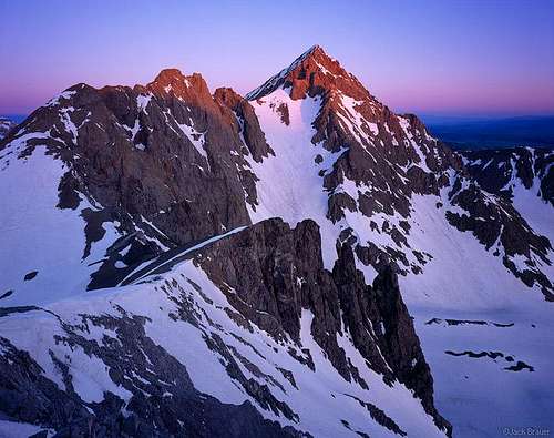 Alpenglow on Mount Sneffels
Route Options
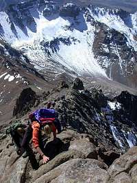
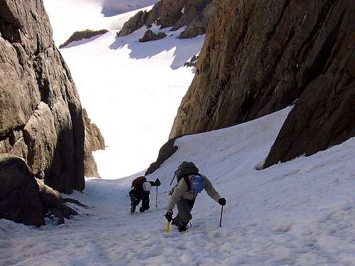
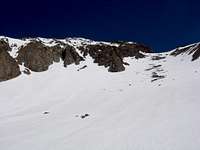
STANDARD ROUTE: LAVENDER COULOIR (Class 2+)This route can either be a very enjoyable climb or a miserable experience, depending on what time of year you go. I would HIGHLY recommend this route when the couloir is filled with good firm snow, as it was when I climbed it. The snow steepness is moderate at the worst and never exceeds 45 degrees. The steepest part is in the upper couloir. Scrambling around the V Notch likely increases to class 3 when snow is on the route. If snow is not to your liking, this route is one long talus hopping adventure, which isn't known for bad rockfall danger but it can happen especially on days where many people are doing this route. A helmet may be wanted on busy days. At the top of the couloir scramble left through the V Notch and continue the last hundred feet on some talus to the summit which appears abruptly. The summit area is surprisingly small and the views are among Colorado's best!
 Lavender Couloir in blue Lavender Couloir in blue |
 At Lavender Col At Lavender Col |
 Down the col Down the col |
 Climbing the V Notch Climbing the V Notch |
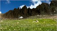
SOUTHWEST RIDGE (Class 3)
Follow the trail to Blue Lakes Pass from the Yankee Boy TH and head right and climb the sustained class 3 ridge that leads right to the summit. Plan on at least a couple hours on this ridge as it is generally pretty loose and has decent exposure.
 Climbing the SW ridge Climbing the SW ridge |
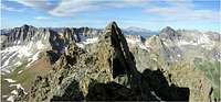 Spine of the SW ridge Spine of the SW ridge |
 Gilpin Peak in the distance Gilpin Peak in the distance |
 SW ridge spires SW ridge spires |
SNAKE COULOIR (AI 2-3, Class 5.5)
A steep snow climb (greater than 45 degrees) and sections of even steeper ice which is then followed by about 100 feet of Class 5 climbing. This route is known for generally solid rock however loose "baby head" and "ball-bearing" rocks litter the route. It's best to descend the standard route to the Sneffels/Kismet saddle and then descend snow/talus/scree back to Blaine Basin and your starting point. This can be done in one long day from the TH, or several hours from a Blaine Basin camp.
 Climbing the Snake Couloir
SOUTH FACE "BIRTHDAY CHUTES"
This route makes for great snow climbs and ski descents on your choice of one of the great couloirs on the south face of Sneffels. Definitely not recommended in dry conditions due to rockfall potential.
 |
 |
 |
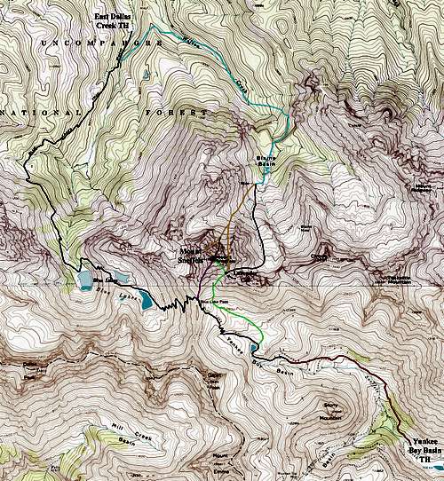 Mount Sneffels Route Map
Red Tape
Unlike in the recent past where severe red tape plagued the Yankee Boy Basin, there is no longer any permitting or major restrictions accessing Yankee Boy Basin, largely thanks to the local communities. Simply practice Leave No Trace principles and keep this beautiful pristine for all to enjoy.
When To Climb
During a normal year, the best climbing conditions for avoiding snow is mid-June through mid-September. It is important to keep in mind that this is prime thunderstorm season and everyone should be off summits and ridges by noon!May through mid-June is the best time for snow climbs in the Lavender Couloir, Snake Couloir or the Birthday Chutes, however snow climbs can be safely done as early as March, depending on the avalanche and snow conditions. Be sure to keep a watch on the avalanche conditions! Snowshoes will likely be needed on any climb before May
Winter and late spring approaches extend required time considerably.
Sneffels can be climbed year-round, however in normal and heavy snowfall years, the road is typically closed at Camp Bird, and the east Dallas road access is closed at the forest boundary gate. Inquire with the Ouray County office about road information before proceeding but expect a considerable increase in distance required for winter climbs.
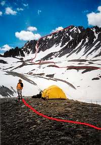
Camping
Yankee Boy BasinCamping in Yankee Boy Basin isn't really allowed, plus it doesn't make much sense. There are many mining claims in the area which are all on private property. The owners don't mind people passing through but they generally do not want people camping there.
Dallas Creek
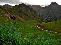
A number of good camping spots are available near the end of the road at the trailhead, and at Blue Lakes. These areas are very popular and fill up quickly during the summer, so get there early if you plan on a backpacking trip. The campsites in Blaine Basin are said to be excellent for beauty and solitude.
Since 2001, camping in Canyon Creek (the road/drainage you drive up to reach Yankee Boy Basin from Ouray) has been in designated sites only. There are 3 camp sites. Listed from lower down the road to the highest, they are Angle Creek, Thistledown, and Atlas. Atlas is near tree-line and only 2 miles or so from the highest Sneffels trailhead. Camping in these sites does cost $10 but isn't worth it in my opinion. These sites do not guarantee anything, don't have water or a table, however there is a fire ring and porta-potty facility.
For more developed camping for those with families or ones that need all the bells and whistles, go to the USFS Ampitheater Campground. It is close enough to provide good access to Mount Sneffels. This campground has hosts, tables, clean bathrooms, firewood and it's located only a few minutes from Ouray where you can satisfy your hunger before embarking on a climb.
 |
 |
 |
Climbing History
Because of its striking appearance, Mt. Sneffels has lured climbers of all abilities since the late 19th century. Sneffels offers many goals and challenging routes varying in difficulty. Many routes have yet to be discovered on this beautiful and complex mountain. Are you one of those route pioneers? If so, Sneffels is the mountain for you.Miners were likely among the first people to climb Mt. Sneffels and the neighboring peaks. The first recorded ascent was by the Hayden Survey team on September 10, 1874. The mountain was named by the surveyors after the Iceland volcano Snaefell, which figured prominently in the classic Jules Verne tale “Journey to the Center of the Earth.”
The next known ascent was made by contractor/prospector Alexander Taylor and Frederick Chapin, climbing the southeast couloir (now the standard route) in 1890. In the 1930s, the range was extensively climbed by the pioneering San Juan Mountaineers. The Sneffels north face was a primary objective. Different routes were established in 1931, 1932 and 1933. According to Dwight Lavender, some of the best climbing in the state was discovered during the development of these routes, and are every bit as difficult as other notable peaks in Colorado, including Coxcomb, Mt. Wilson, Capitol and Lizard Head.
The San Juan Mountaineers also pioneered climbs of the pinnacles surrounding Sneffels 1932-1934, but Purgatory Point, west of Sneffles, was not scaled officially until May 1958 by Henry L. and Frank McClintock, according to Trail and Timberline. David Lewis and Frank McClintock also scaled the northwest ridge that year.
The first winter ascent was executed in 1934 by Mel Griffiths and Gordon Williams. The approach was from Blaine Basin, then joining the standard route. This event was regarded as the advent of winter mountaineering in the San Juans. A notable accomplishment in later years was the winter 1983 ascent of the north face east couloir with a traverse onto the main face, followed by a direct climb. Kitty Calhoun and Lyle Dean pioneered the route, reporting sixty degree snow slope, mixed and varied rock pitches, and a bivouac about half way up.
Aknowledgements: Guide to the Colorado Mountains by Robert Ormes, 4th revised edition; The Majestic Fourteeners...Colorado's Highest by George Crouter; The San Juan Mountains-A Climbing and Hiking Guide by Robert F. Rosebrough. All excellent and informative reading!
Blue Lakes Basin
Not only are the Blue Lakes a great spot from which to climb the surrounding peaks of the Mount Sneffels Wilderness, but they are also situated in one of the most beautiful mountain paradises in the world! Check out the photos in this section for some real eye candy!
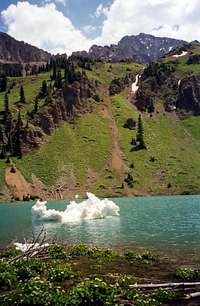 Blue Lakes Blue Lakes |
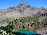 Mount Sneffels Mount Sneffels |
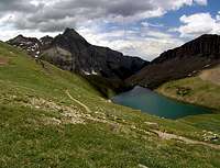 Blue Lakes Blue Lakes |
 Wildflowers Wildflowers |
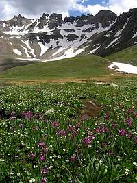
Yankee Boy Basin
The staging point for climbs of Mount Sneffels, Gilpin, Kismet, Cirque, Teakettle and Potosi Peaks, Yankee Boy Basin is also known for its old mining relics, spectacular jeep road and stunning wildflowers. Perhaps the greatest haven for Columbines, the Colorado State Flower, Yankee Boy Basin's reputation is well earned.
 Mount Sneffels under spring snow Mount Sneffels under spring snow |
 Teakettle Mountain Teakettle Mountain |
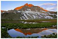 Gilpin Peak reflection Gilpin Peak reflection |
 Gilpin Peak Gilpin Peak |
The Summit View
I remember when I climbed Sneffels that the view from its summit was particularly fantastic with Dallas Peak across the valley and the rugged Sneffels Range surrounding you. One of the few peaks I am considering doing again!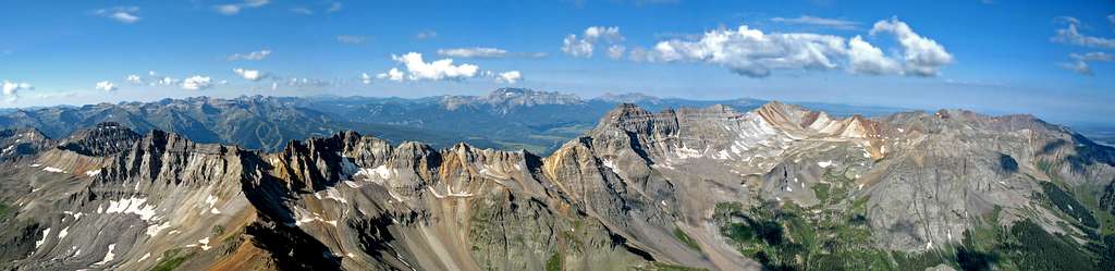
Mountain Conditions and Additional Information
14ers.comUncompahgre National Forest
Ouray Information
Ridgeway Information
Summitpost Ouray Ice Park Page
Gerry Roach's Colorado 14ers book is essentially the bible for climbing the Colorado 14ers.