
-
 17631 Hits
-
 85.72% Score
-
 21 Votes
|
|
Canyon |
|---|---|
|
|
37.01674°N / 111.87936°W |
|
|
Canyoneering |
|
|
Spring, Summer, Fall, Winter |
|
|
Overview
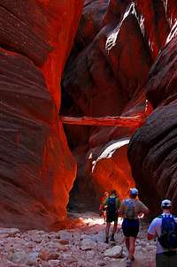
The Buckskin Gulch, in the Paria Canyon-Vermillion Cliffs Wilderness Area, is one of the best-known tributaries to the Paria River, with which it merges nearly at the Utah-Arizona border. Beginning just east of the Cockscomb and cutting spectacularly through Navajo sandstone, it is one of the longest slot canyons in the world. tanya's incredible capture of the essence of the Buckskin experience
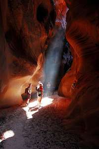

Getting There
All access is from the section of Hwy 89 between Kanab, UT and Page, AZ.


On one end is the White House Trailhead, at the end of a gravel road by the same name, which turns south from 89 not far east of the crossing of the Paria. An 11 km (6.8 mile) walk down the (likely mostly dry) streambed leads to the confluence with the Buckskin.
On the other end are the Buckskin and Wire Pass Trailheads, which are accessed via the House Rock Valley Road which follows the Cockscomb. Wire Pass is the more downstream one, saving 4 km (2.5 miles) off the 26 km (16 mile) distance to the confluence with the Paria.
Finally, there is a "Middle Trail" car park, which accesses a scramble into or out of the middle of the Buckskin narrows. It is advisable to bring a rope for hauling your gear on this scramble as it is quite steep and exposed. Routefinding is also required between the notch and the car park. To reach this area, do the following (these coordinates come from a Google Earth inspection):
- Turn east off House Rock Valley road at about 37º05'28" N, 111º59'13" W.
- Go south-ish at a junction around 37º05'04", 111º58'41"
- Bear right onto Long Valley Road at around 37º03'55" N, 111º57'39" W.
- Bear left again very shortly at around 37º03'49" N, 111º57'40" W.
- Proceed to the trailhead at about 37º2'39" N, 111º55'13" W.
Alternatively, Long Valley Road is directly accessible from Hwy 89 at Sand Gulch.
Camping and Preparation
The entire trip down Paria and up Buckskin, or vice versa, can be done in one long day, but it is best to do it over two to four days. It is also recommended to do the loop, rather than in-part-way-and-out, in order to minimize the human load on the canyon. Alternatively, many parties continue from the confluence down the Paria to Lee's Ferry, an additional distance of about 51 km (31.5 miles), a good 3-day hike for most people.There is permanent water near the confluence (but it is discouraged to camp there as it gets a lot of traffic), but I was there in a drought year and the stream was just a trickle in the sand. We carried all our water, but this is probably not typical. Other water sources (i.e. cesspools) are also sources of too much else to be good for drinking or perhaps even filtering.
Be advised that conditions change with each flash flood and may require wading or swimming and pack-floating in cold and unattractive water, and you may encounter quicksand. Bring dry bags and/or a flotation device for your pack. There is a rockfall for which some people may wish to have a handline. Holds have been chipped into the rock, but you may still wish to raise or lower your packs with a rope.
 Do not go here without a very dry weather forecast.
Red Tape
This permit info is for Buckskin Gulch and the Paria River in the Wilderness Area; different regulations may apply to other areas of the Wilderness.Day use permits are via self-serve envelopes at each trailhead and there is no visitor use limit. $6 per person or dog.
Overnight use requires advance permits, and there is a 20 person per day limit. $5 per person or dog per day. At the beginning of each month, reservations for 3 months later are opened, and popular days fill quickly.
Practice especially strict Leave No Trace methods in these canyons due to the fact that any such trace you leave is basically going to be in the path. Bags for packing out human waste, which is mandatory, are free at the Paria Ranger Station, Kanab Field Office and Arizona Strip District Office.
See the BLM's permit page for the Paria Canyon/Vermillion Cliffs Wilderness for more complete or up-to-date information. Or call the field office at (435) 688-3200.
External Links
BLM Paria Canyon-Vermillion Cliffs Wilderness Area pageUSGS real-time Paria River stream flow data
Apply for Paria Canyon permits
More permit info
Maps and Guidebooks
USGS 7.5' Quads:Pine Hollow Canyon (Wire Pass area)
West Clark Bench (most of Buckskin Gulch, and the White House area)
Bridger Point (confluence and part of the Paria)
USGS Smoky Mountain 30'x60' Quad.
Michael R. Kelsey, 1998. Hiking and Exploring the Paria River. Provo: Kelsey Publishing