
-
 4169 Hits
-
 71.06% Score
-
 1 Votes
|
|
Mountain/Rock |
|---|---|
|
|
38.96486°N / 111.62611°W |
|
|
Sevier |
|
|
Hiking |
|
|
Spring, Summer, Fall, Winter |
|
|
9318 ft / 2840 m |
|
|
Overview
The major fault line along the Eastern side of Sevier Valley creates a series of mountain ridges that increase in elevation as you travel east from Redmond and Salina, Utah. The third, and highest of these forested mountains, is Bull Valley Mountain.
Getting There
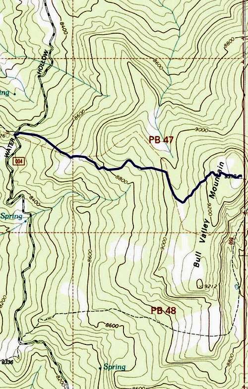
From Salina, Utah, take US-89 3.5 miles and turn left onto 3500 Redmond Switch Road toward Willow Creek. Continue for 2.4 miles then take a soft right onto Willow Creek Road. Drive for 11 miles. After a clearing, take a hard right (almost a U-turn) onto FR004 (Water Hollow Road). Drive 2.9 miles to the pass where an obvious ATV trailhead is on the right side of the road.
Route
Once at the clearing, find the trail hidden in the brush on the east side of the road. Follow the trail along a fence until you get to a clearing. Continue east through the meadow and find your way through a weakness in the aspen to another clearing. Travel straight east across the meadow and you will find the pack trail once more. It becomes 15 feet wide through the pine trees then nearly disappears. Meander along the scattered traces of the trail until you come to a large fence composed of horizontal, bleached pine poles. The pack trail becomes much more apparent here. Continue on this trail along the fence. The fence eventually turns south for a quarter mile on the west side of a gully. When the fence turns east/northeast again, stay on the trail the travels along its flank rather than going straight (south). This trail and fence will get you to the meadow just to the west of the summit. The Aspen grove on the east side of the meadow is the summit. The descent consists of retracing your steps.
Round-trip Distance: 3.2 miles
Elevation Gain: 725 feet
Gaia Track for Bull Valley Mtn
Red Tape
The peak is on land managed by the US Forest Service.
When to Climb
Year-round, but bring snowshoes in winter.
Camping
There’s a ton of camping sites along Willow Creek Road and throughout the area if you hope to sleep outside. Otherwise, the small town hotels are not far away.