
-
 25240 Hits
-
 86.85% Score
-
 23 Votes
|
|
Mountain/Rock |
|---|---|
|
|
29.03445°N / 13.73171°W |
|
|
Hiking |
|
|
Spring, Summer, Fall, Winter |
|
|
1503 ft / 458 m |
|
|
Overview
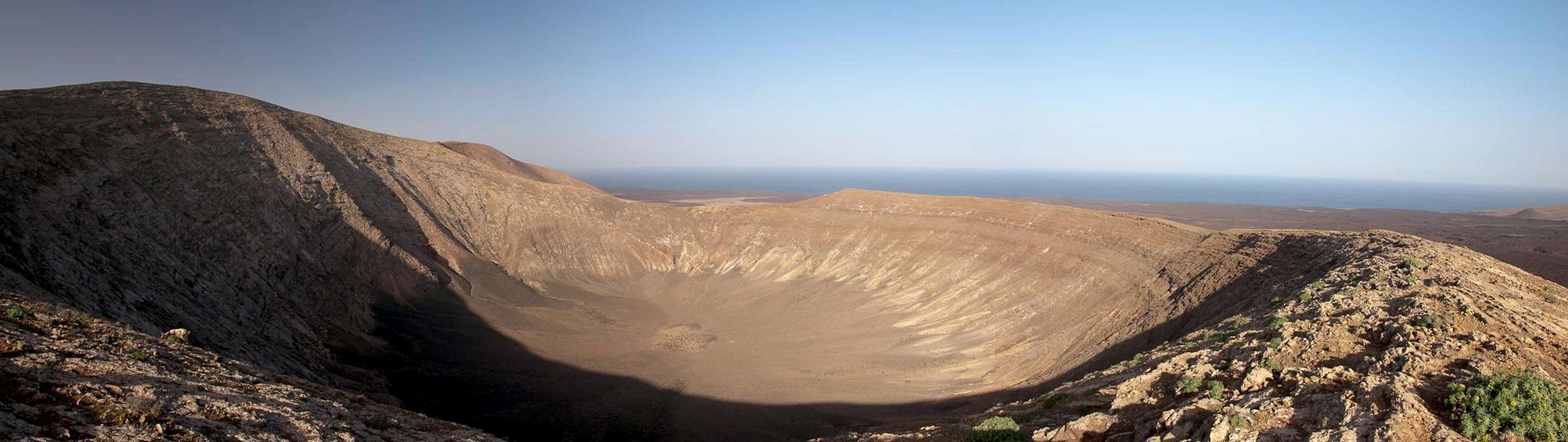
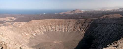 The Crater of Caldera Blanca as seen from its summit The Crater of Caldera Blanca as seen from its summit |
Caldera Blanca is an extinct volcano in the north-west of the Canary Island of Lanzarote. Far from being the highest of the many volcanoes of the island, Caldera Blanca's is certainly the widest by far. Measuring 1.15km in diameter it is perfectly circular with high walls all around - very rare for craters this size. Its highest point is located to the south-west of the caldera, the lowest one is to the north-east. This provides us with a little lesson about the formation of such craters. During the eruption north-eastern winds must have prevailed (the most common climate pattern even today). Most of the times these winds were fierce (also encountered today) but for quite a while a lull must have allowed the build-up of the northern walls.
The name Caldera Blanca - White Crater - already indicates that it is not of recent origin. Created during the end of the second phase of volcanic activity on the island - between 3000 and 5000 years ago - Its rocks have already bleached into some sort of dirty beige. Caldera Blanca only appears white in its surroundings, the sea of lava which was produced during the Timanfaya eruptions of 1730 - 1736).
 East East |
 South-East South-East |
 West West |
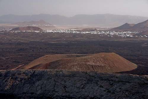
Indeed, Caldera Blanca with its lower neighbours La Caldereta (324m) and Risco Quebrado (312) forms a so-called "Islote", an island amonge the lava sea. The LLava streams couldn't reach up as high and on the lee side of the three volcanoes small patches of "old country" stretch towards the sea. Even today these patches are used by the farmers of the neighbouring village of Mancha Blanca for the typical Lanzarotenian dry cultures of wine, figs or onions. The crater of Caldera Blanca itself is very popular among the goat herders of the island since it can easily be supervised.
  |
Caldera Blanca is one of the few volcanoes in the greater area of the Parque Nacional de Timanfaya and Parque Natural de los Volcanes which can and may be climbed. Consequently the 3 - 4h round trip (also around the crater) is one of the popular hiking routes of the island. The Proximity of the Montañas del Fuego ensures good views of the volcanic moonscape. But don't despair - Lanzarote tourists prefer the beaches ...
360° Summit Panorama
 |
Getting There
|
The best trailhead for Caldera Blanca is west of the village of Mancha Blanca. The best itinerary (not the shortest but most impressive one) is as follows:
- From Arrecife follow LZ20 through San Bartolomé.
- At the Monumento del Campesino turn onto LZ30 west.
- Drive through Masdache and at the intersection with LZ56 turn northward in direction Tinajo.
- Drive through Mancha Blanca, where you follow the signs for the Timanfaya Park (LZ67).
- About 500m after you leave the village where LZ67 turns to the south-west you can find the best trailhead.
Red Tape
 South South |
 North-West North-West |
 South-East South-East |
Caldera Blanca is located in the Parque Natural de los Volcanes. For locals, farming is allowed in the park but all construction or quarrying activities are restricted to some very few areas. It took flora and founa hundreds of years to conquer the volcanic cones so please leave everything in its place.
Accommodation
 Looking from the crater rim towards Tinajo
Though there are ferries from the Spanish mainland to the Canary Islands, they take more than 24h for the trip. Therefore most visitors therefore go by plane. Every travel agency in Europe offers flights, hotel rooms, apartments, rental cars etc. so that reaching the Canaries is rather a matter of money than opportunity. During the summer season flight fares can be reasonable but during the Easter and Christmas holidays you have to be prepared for additional fees of 500€ per person.
Lanzarote has its own airport between the capital Arrecife and one of the main tourist centres, Puerto del Carmen. There are public bus lines but – like on all the islands – they don't run too regularly. If you plan to stay on your own, better take a rental car right at the airport.
As for holiday homes, hotels or apartments either consult your nearest travel office, or – search for lodgings on Google. There are several sites on the web, dedicated to rent privately owned houses or apartments. Prices are generally a bit less expensive than for tour operators but you don't have as much security.
Weather Conditions
As stated in the overview section, Lanzarote, is usually swept by fierce north-western trade winds. Though they deposit their humidity on almost all of the other Canary Islands, Lanzarote is simply too low to form a decent obstacle. Therefore the climate is very arid.
For some time of the year, eastern winds prevail, which almost always carry clouds of Sahara dust with them. Usually this means reduced visibility but in some occasions "Calima" occurs. Fierce storms take up the dust from the Sahara and sweep it across the islands. In these times visibility is nil and sometimes even the planes are grounded.
Maps & Books
Maps
Regular Maps
- Lanzarote
Kompass Map WK241
Kompass Verlag
1:50000
ISBN 3-85491-175-0
Digital Maps
Kompass is the only company known to me which offers GPS digital Maps. In addition for those of you with Garmin GPS receivers there is a map source map set of all Canary islands out there.
- Lanzarote
Kompass GPS4241
Kompass Verlag
ISBN 3-85491-223-4 - Islas Canarias
Map Source custom map
By Manfred Pepper
downloadable zip-file
Books
My recommendation is a guidebook by Rother Verlag, available in German. The book is an excellent hiking guide covering all the interesting areas of the island. Since it comes with small maps for each excursion it might even be used without a map to support them.
- Lanzarote
Rolf Goetz
Rother Verlag
ISBN 3-7633-4302-4