Municipality Champorcher is not located & placed into Aosta Valley, but in an other world. Out there beyond the Parks. Those of "Grampa" or Paradiso (4061m) to the West and North of wild & very ancient Mount Avìc (3006m).
Because this common, with all its valley that descends from the
Rosa dei Banchi (3164m) in the southwest, from the
Ponton Tower (3101) to the West and by the
"coupled pair" Mont Delà / Mont Glacier (3139, 3186m) to the North, flowing diagonally to the Northeast,
"anxious" to reach the Dora Baltea at Fort Bard to finally slip into the Piedmont adjacent Region. A striking image for the inhabitants and the populatios of these places on the edge of the parks of Gran Paradiso and Mont Avic. Almost, if not rejected, at least
"discarded" by them. But also, if not bloody, definitely raw for a location seemingly out of touch. Indeed, I do not know why, but every time I go in Champorcher Commune with its valley I not seem to be more into the Valley of Aosta. But, if anything in the nearby Piedmont.
But it is a passing sensation, because soon I will go to
"collide himself" with the masses, in a long single file, directed to the
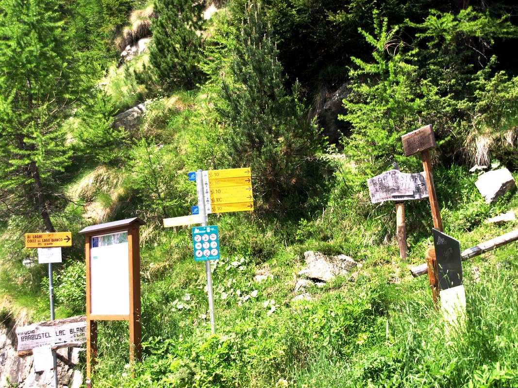
Regional Park of Monte Avic from La Cort small Village and to the North and one facing the Sanctuary Miserin in the Southwest. Few however will go to the West and, through the Finestra or Window of Champorcher and Hill of Pontonnet, will travel farther in the splendid
Gran Paradiso National Park. Because the first is a beautiful short walk suitable for all the people, while the second is a long hike. Before going down to the refuge
"Sogno di Berdzé or Dream of Shepherd" in the following Valley of Urtier and to the next Valley of Cogne. Beautiful, but enough remote. Because while from the Hamlet of
Lillaz (1612 m) you can also climb by the horse, hence however necessary to
"polish" good hocks and
"arm themselves with good patience".
There are a hundred other roads leading in all cardinal directions allowing you to make good discoveries. Of all kinds and for all tastes. Seeing is believing ...
Pontboset or Pont Bozet to Champorcher-Château
Champorcher non é collocato in Valle d'Aosta, bensì in un altro mondo. Là al di là dei Parchi. Quelli del "Grampa" ad Occidente e del Mont Avìc a Settentrione.
Perché questo comune, con tutta la sua vallata che scende dalla
Rosa dei Banchi (3164 m) a Sudovest, dalla
Torre Ponton (3101) ad Occidente e dall'accoppiata
Mont Delà/Mont Glacier (3139, 3186 m) a Settentrione, scorre in diagonale verso Nordest,
"ansiosa" di raggiungere la Dora Baltea presso il Forte di Bard per infine scivolare verso il Piemonte. Un'immagine suggestiva anche per gli abitanti e le popolazioni di queste località ai margini dei parchi del Gran Paradiso e del Monte Avìc. Quasi, se non respinte, almeno
"scartate" dai medesimi. Ma anche, se non cruenta, sicuramente cruda per una località apparentemente fuori dal mondo. Anzi, non sò perché, ma ogni volta che mi reco a Champorcher mi sembra di non essere più in Valle d'Aosta. Semmai in Piemonte. Ma é una sensazione passeggera,perché presto andrò a
"scontrarmi" con le masse, in lunga fila indiana, dirette verso il
Parco Regionale del Monte Avìc da La Cort e verso Nord e quella verso il
Santuario del Miserin a Sudovest. Pochi invece andranno ad Occidente e, tramite i Colli Finestra di Champorcher e del Pontonnet, si recherenno nel più lontano
Parco Nazionale del Gran Paradiso. Anche perché la prima é una bella e corta passeggiata adatta a tutti, mentre la seconda risulta una lunga escursione. Prima di scendere al
Rifugio "Sogno di Berdzé" nel Vallone dell'Urtier e verso la successiva Valle di Cogne. Bella, ma lontana. Perché mentre dalla Frazione di
Lillaz (1612 m) si può anche salire a mezzo di cavallo, da qui invece bisogna
"lucidare" bene i garretti ed
"armarsi di santa pazienza".
E comunque esistono altre cento strade che conducono in tutte le direzioni cardinali permettendo di fare belle scoperte. Di ogni tipo e proprio per tutti i gusti ...
Southern entrance towards the Mont Avic Regional Park
![]()
Getting There from Hône/ Bard towards Pon Bozet & Champorcher
By car:
- From TORINO, MILANO, etc: Motorway A5. Exit at IVREA or Quincinetto (PIEDMONT)
From IVREA Town: Pont Saint Martin, Donnas, Hone, Bard, Municipalities.
![]()
Specific Main Road
From Bard to Hône (364m, 566m) Commons, crossing on Dora Baltea Stream after a deviation by the State Road; this last towards Pont Bozet (775m) to Champorcher Valley, Camporcher-Château (1427m), Petit, Grand Mont Blanc, La Cort Villages, towards Dondena Village (2092m), Dondena & Miserin Refuges, through Royal Road & secondary dirt roads; Barbustel Refuge, through Royal Road and path towards Champdepraz Vallon.
![]()
- From FRANCE: through the Mont Blanc Tunnel to Entrèves-crossroads to Vény/Ferret Valleys - Mountain Guides of Courmayeur - La Saxe Rock Gym - Courmayeur. By Little Saint Bernard Pass, closed since November until half May to La Thuile Valley - Pré Saint Didier - Courmayeur.
It is not necessary to take Motorway A5: you can drive on State Road n° 26, in the direction of AOSTA - IVREA - TURIN.
By plane:
- Aeroporto Internazionale "Corrado Gex" Saint Christophe (Aosta)
Roaming & wandering here and there ...
Bec Colinas in foreground & just above Champorchet Resort.
Comments
No comments posted yet.