
|
|
Mountain/Rock |
|---|---|
|
|
52.64272°N / 4.00651°W |
|
|
Gwynedd |
|
|
Trad Climbing, Toprope, Bouldering |
|
|
Spring, Summer, Fall, Winter |
|
|
846 ft / 258 m |
|
|
Overview
| “Craig Aderyn is a most picturesque and lofty rock, so called from the numerous birds which nightly retire among the crevices: the noise they make at nightfall is most hideously dissonant, and as the scenery around is extremely wild and romantic, the ideas engendered by such a clamour in the gloom of evening and in so dismal and desolate a spot are not the most soothing or agreeable. Towards twilight some large aquatic fowls from the neighbouring marsh may be seen majestically winding their way to this their place of nocturnal rest.” William Cathrall – The History of North Wales (1828) |
Hidden deep in the rarely frequented valleys of Meirionnydd is a mountain with one of the most imposing north faces in Wales. Steep and inaccessible, even the area’s usually fearless feral goats dare not tread on its unforgiving rocky precipices. To directly reach its summit from this angle requires the skill and strength of an experienced climber, and even then, any climber attempting to do so would have to choose their moment carefully; as for almost half the year climbing is banned here, and for the other half, it is hampered by the arrival of frequently bad weather. The mountain is called Craig yr Aderyn (Bird’s Rock), and by now, you might be wondering why you’d never heard of it before. The answer to this puzzle is probably down to the fact that, although for all intents and purposes, Craig yr Aderyn displays all the characteristics of a real mountain, it only reaches 846 feet in height; just over 1,000 feet short of making it a true mountain, at least by Britain’s modest standards. The rock juts sharply out of the low-lying Dysynni Valley, just west of southern Snowdonia’s most famous attraction, Cadair Idris, and if it weren’t for the nature of the local topography, would be an inexorable feature of the area’s landscape. Once the Irish Sea inundated the valley, and Craig yr Aderyn formed the area’s highest sea cliffs; however since then the sea has retreated, leaving the rock some five miles from the present coastline. Although the sea has long since departed, the sea birds have not, and the rock supports a breeding colony of cormorants, the only regular inland nesting site in Wales. A number of other breeding species share the cliff’s caves and crevices, including chough, barn owl, peregrine, redstart, wheatear, linnet and little owl. It is the chough though, an increasingly rare bird in Britain, that elevates Craig yr Aderyn from a simple nature reserve to a site of international importance, and which justifies its designation as a Special Protection Area and a member of the European Union’s Natura 2000 Network. It is also this presence of choughs that results in a seasonal restriction on climbing that affects some of Craig yr Aderyn’s rock faces. The hill has some of the best climbing in Meirionnydd, and is host to a range of climbs spanning the British grading spectrum. Generally its rock is clean, offers good protection, and when not raining, remains reasonably dry. This coupled with its close proximity to the road, makes it something of an oddity in an area characterised by routes which support more greenery than the Royal Botanic Garden, and have walk-ins that demand a Shackletonesuqe tenacity to complete. Craig yr Aderyn is therefore an ideal spot to introduce the uninitiated into the world of Meirionnydd climbing.
There are four principal crags used for rock climbing, the Eastern Face, the Central Buttress, The Bastion and the Col Crag. The Eastern Face has the longest routes, however these are all subject to the aforementioned seasonal restriction imposed by the choughs. To its right is Central Buttress, which has an upper and lower tier, and is also subject to the restriction. Next comes The Bastion, the most popular part of the rock, which contains a mixture of single and multi-pitch routes, none of which are subject to any kind of restriction. Finally, The Col Crag is located a short distance to the south of the main crags, and can be accessed by walking for some 15 minutes along a progressively indistinct footpath. The crag contains a small number of short climbs and is an ideal spot to while a way a few hours of relaxing bouldering. Craig yr Aderyn’s summit is capped by a small hill fort which is generally thought to date from the Iron Age. The fort walls line the crests of the hill's lower terraces, which back onto the Eastern Face. Its walls, now covered in turf, meet at an angle on an outcrop and fade away into the steeper slopes of the hill. The area enclosed within the fort’s walls is very small, and although no sure evidence of habitation has been found, artifacts discovered at the site include Roman pottery, a weight or plumb bob of rolled sheet lead and part of a curved lead bar, possibly an armlet. Local folklore says that during the Middle Ages a tower was sited on top of the fort, which was used to warn the nearby castle, Castell y Bere, of any oncoming threats. The Royal Commission on the Ancient and Historical Monuments of Wales has more information about the site. |


View to the east. The mountain in the centre of the photo is Cadair Idris (Photo by Nanuls)
In Popular Culture
For such an obscure rock, Craig yr Aderyn has a surprising number of notable references in popular culture. The first is arguably not popular, but is culturally significant from a Welsh point of view. The rock is mentioned in an old well known Welsh folk song 'Wrth Fynd Efo Deio i Dywyn' (While Going with Deio to Tywyn), which describes the journey of two friends from Brithdir near Dolgellau to Tywyn on the coast.
The song has been covered by a number of Welsh rock and folk bands, and was described by singer/songwriter Cerys Mathews as a being like “pub crawl across Wales”. The full lyrics can be found on Wales' version of Wikipedia - Wicipedia. More people will be familiar to the second literary reference because it comes from Susan Cooper's The Dark is Rising Sequence. The fourth book in the sequence, The Grey King is strongly based on real Welsh topography, and in particular that of the Dysynni Valley. Craig yr Aderyn therefore plays an important role in the books landscape, and although the books dedication states that Clwyd Farm is fictional, if it did exist it would be located only a few hundred metres from the base of the the rock. Recently the The Dark is Rising Sequence has been adapted into a movie called The Seeker: The Dark Is Rising, which received mixed reviews at best. |
Wildlife and Conservation - The Birds of Craig yr Aderyn
 Craig yr Aderyn SPA Craig yr Aderyn SPAThe primary reason for the sites selection are of course its choughs (Pyrrhocorax pyrrhocorax) a member of the Corvidae family, which will be familiar to mountaineers across Europe. British choughs have black plumage, and are distinguishable from other crows by their red bill and legs. Craig yr Aderyn is the seasonal home to a growing metapopulation of birds which largely originate in Ceredigion and Montgomeryshire in the south. The crag used to regularly support over 1% of the British population of breeding chough, with five or six pairs nesting in holes and crevices, making it at one time the densest population of breeding chough in the British Isles (six pairs in 0.5Km). However, in recent years breeding numbers have declined to 3-4 pairs. Craig yr Aderyn is now more important as a year round roost site, with non-breeders in the summer and high numbers outside the breeding season. According to the Countryside Council for Wales (CCW), during the period 1991/92-1995/96 the average maximum count was 56 individuals, however since then the number of roosting birds has fallen to an average of 18 during the 1999/00-2004/05 period. The secondary reason for Craig yr Aderyn's selection are its cormorants (Phalacrocorax carbo). The cormorant is a large, mostly black coloured waterbird with a long neck and almost reptilian appearance. They are supreme fishers with a diet that largely consists of fish but can also include crustaceans, amphibians, molluscs and nestling birds. The nesting colony at Craig yr Aderyn numbers over 60 pairs, which represent about 1% of the GB breeding population. The colony was first recorded by Edward Lluyd in 1695 and was also mentioned in Thomas Pennant’s “Tour in Wales” in 1784. |

The Col Crag (Photo by Nanuls)
To the north and east of the crags, there is a large area of unimproved acid grassland mixed with bracken. This is one of the major factors influencing the number of breeding and roosting chough, as they require an unimproved sward, rich in their main food, soil invertebrates and short enough for chough to be able to use their beaks to probe for food. Acidic, dry heathland occurs in the south-eastern part of the site. A small area of base-enriched marshy grassland above Gesail adds to the plant diversity with species such as common butterwort (Pinguicula vulgaris,) many-stalked spike-rush (Eleocharis multicaulis) and pale sedge (Carex Pallescens) and mosses such as (Campylium stellatum), (Ctenidium molluscum) and (Fissidens adianthiodes). The north facing cliffs and slopes support a good range of moss and liverwort species. Of particular note are the nationally scarce mosses growing on boulders in the scree; Grimmia decipens, which appears to be decreasing in its national range and Hedwigia integrifolia which occurs here at its southernmost location in Britain. The uncommon liverwort (Jubula hutchinsiae) has been recorded from streamside rocks. On rocky areas above the main cliff face Wilson’s filmy fern (Hymenophyllum wilsonii) and oak fern (Gymnocarpium dryopteris) have been recorded. General Site Character Inland water bodies (standing water, running water) (1.0%)Dry grassland. Steppes (64.0%)Inland rocks. Screes. Sands. Permanent snow and ice (31.0%)Other land (including towns, villages, roads, waste places, mines, industrial sites) (4.0%) |


Rock Climbing
Now for the important part; this section lists all the recorded routes the crag has to offer. Crags and climbs are listed from left to right, and are graded and rated with the aid of the Climbers' Club Guide to Meirionnydd, and Paul Williams’ Rock Climbing in Snowdonia. Technical grades are only given to climbs graded adjectivally as Hard Severe (HS) or above. Where the sources differ in their grading I have opted to list the highest quoted grade only, as I don’t want to mislead anyone about the seriousness of any of the routes. A conversion table of international climbing grades by SP member Corax is available HERE!. In addition quality ratings have also been included, these are based on the three star system commonly used in British guidebooks. Route Symbols:
Despite the addition of a few bolts for belays on the Col Crag, Craig yr Aderyn remains to be a trad climbing venue, and that additional bolting is strictly prohibited. Since the crag is such an important conservation site, it’s important that this rule be abided by, lest further restrictions be placed on climbing here. Eastern FaceThis is the largest of the crags at Craig yr Aderyn, and is consequently home to the longest routes. It’s located above a small quarry, is home to an assortment of birds, and is subsequently subject to the seasonal restrictions that accompany them (see the red tape section for further details). It is also more vegetated than its neighbouring crags and home to some fairly dubious rock, so take care if climbing here. A generous helping of guano should be enough to put most people off climbing this face. With the exception of Safe as Sausages, all routes are approached from the right. |

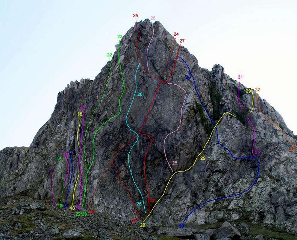
Routes on the Eastern Face. For a clean version of the photo click HERE
| No. | Name | Length | Pitches | Adjectival Grade | Technical Grade | Quality | Restrictions |
|---|---|---|---|---|---|---|---|
| 1. | Safe as Sausages | 43m | 1 | HVS | 4c |  | |
| 2. | The Talon | 88m | 4 | S | | | |
| 3. | Dinner and the Duo | 94m | 4 | VS | 4b, 4b | | |
| 4. | December Grooves | 76m | 4 | HVS | | | |
| 5. | Guano Pinnacle | 95m | 3 | HS | 4a, 4a | | |
| 6. | Plume | 98m | 3 | S | | | |
| 7. | Great Spotted Booby | 70m | 3 | VS | 4b, 4c, 4b | | |
Central ButtressThe Central Buttress connects the East Face to the Bastion, and has an upper and lower tier. The upper tier is dominated by prow like overhangs, while lower tier terminates at a small track which comes in from the left. The crag is subject to the same restrictions as the East Face (see the red tape section for further details). |

Routes on the Central Buttress. For a clean version of the photo click HERE
| No. | Name | Length | Pitches | Adjectival Grade | Technical Grade | Quality | Restrictions |
|---|---|---|---|---|---|---|---|
| 8. | Barking at the Moon | 24m | 1 | E1 | 5b |  | |
| 9. | The Howling | 24m | 1 | E2 | 5c | | |
| 10. | Siesta | 34m | 1 | S | 4a | | |
| 11. | Day of the Tripheads | 24m | 1 | E2 | 5c | | |
| 12. | The Beak | 60m | 3 | VS | 4b, 4b | | |
| 13. | Gorilla's Armpit | 38m | 2 | HVS | 4c, 5a |  | |
Routes on the North Face of The Bastion. For a clean version of the photo click HERE
| No. | Name | Length | Pitches | Adjectival Grade | Technical Grade | Quality | Restrictions |
|---|---|---|---|---|---|---|---|
| 14. | Dragonfly | 12m | 1 | E2 | 5b | | |
| 15. | Giblet | 18m | 1 | E1 | 5b | | |
| 16. | The Gizzard | 18m | 1 | HS | 4b | | |
| 17. | Lunar Moves | 34m | 1 | HVS | 5a | | |
| 18 | The Jug | 34m | 1 | S | 4a | | |
| 19. | Pedestal | 34m | 1 | HS | 4b | | |
| 20. | Spike Wall | 40m | 1 | VS | 4c | | |
| 21. | The Great Mogul | 57m | 2 | E2 | | | |
| 22. | Koh-I-Noor | 40m | 1 | E2 | 5a | | |
| 23. | Diasy Belle | 39m | 2 | E1 | 5a, 5b | | |
| 24. | The Diamond | 45m | 2 | E4 | 5b, 5c | | |
| 25. | Diamond Eliminate | 45m | 2 | E4 | 5b, 5c | | |
| 26. | The Dark Road | 45m | 2 | E5 | 6a, 6a |  | |
| 27. | System of Romance | 57m | 3 | E4 | 6a, 5c | | |
| 28. | Pink Panther | 59m | 3 | E3 | 5b, 5c, 5c | | |
| 29. | The Diagonal | 37m | 2 | S | | | |
| 30. | The Bolero | 36m | 2 | HVS | 5a, 5a | | |
| 31. | Birdcage | 33m | 3 | HS | 4b | | |
| 32. | The Buttress | 41m | 3 | VD | | | |
| 33. | Rockerfeller | 21m | 1 | HS | 4b | | |
| 34. | North Face Girdle | 90m | 4 | HVS | 5a, 5b, 4c | | |
West Face |

Routes on the West Face of The Bastion. For a clean version of the photo click HERE
| No. | Name | Length | Pitches | Adjectival Grade | Technical Grade | Quality | Restrictions |
|---|---|---|---|---|---|---|---|
| 35. | Chouca Rib | 60m | 4 | VD | | | |
| 36. | Picket Lin | 59m | 3 | HS | 4b | | |
| 37. | Curly Fringe Frown | 39m | 2 | VS | 5a, 4c | | |
| 38. | The Rockery | 51m | 3 | S | 4a, 4a | | |
| 39. | Goat Walk | 42m | 2 | M | | | |
| 40. | Black Monday | 20m | 1 | VS | 4c | | |

Routes on the Col Crag. For a clean version of the photo click HERE
| No. | Name | Length | Pitches | Adjectival Grade | Technical Grade | Quality | Restrictions |
|---|---|---|---|---|---|---|---|
| 41. | Lion Bastard | 8m | 1 | VS | 5a | | |
| 42. | Little Tommy Pickles | 12m | 1 | E2 | 5b | | |
| 43. | Ageneration | 12m | 1 | VD | | | |
| 44. | Roger Rabbit | 12m | 1 | VS | 4c | | |
| 45. | St Benet's Rd | 12m | 1 | VD | | | |
| 46. | White Streak | 11m | 1 | VS | 4b | | |
| 47. | Chucky Vinster | 11m | 1 | VD | | |
Mountain Conditions
This section displays the mountain conditions for Snowdonia, of which Craig yr Aderyn is part. Click on the widget for maps and further information. This Snowdonia weather forecast is generated by the Met Office Weather Widget |
When to Climb and Essential Gear
The most reliable conditions are in the summer, but the low altitude of the crag may make it a viable option in winter when the area’s higher routes are too wet to be enjoyable. The gear needed depends entirely on the routes you plan to do. Easier routes will only require a moderate rack, while longer harder routes will require a full rack with a good compliment of friends. A singe 60 metre rope should serve well on most routes, however, twin or double ropes would be a wise choice for the harder stuff. |
 Craig yr Aderyn from the opposite hills © Copyright Chris Denny and licensed for reuse under this Creative Commons Licence |  The route to the Col Crag, see the Rock Climbing section or click on the image for further details (Photo by Nanuls) The route to the Col Crag, see the Rock Climbing section or click on the image for further details (Photo by Nanuls) |  Climbers top-roping on the Col Crag © Copyright Tim Jones and licensed for reuse under this Creative Commons Licence |
Getting There
Most visitors to Craig yr Aderyn will approach the rock from the east, if you have to approach from the west, then you clearly know the area well enough already, and therefore don’t need a section such as this to help you get there. So, if you are coming from the east, you need to turn off the A470 at the Cross Foxes Inn junction (SH 766 167), and drive south along the A487 for some 6km to the junction for the B4405 near the Minffordd Hotel (SH 732 114). For those familiar with the area, this is the same turning as you would take for the car park on the southern side of Cadair Idris where the Minffordd Path starts. Drive along the B4405 as far as Abergynolwyn (SH 677 069). In the centre of the village there is a crossroads, turn right here and drive north up a narrow unclassified road to another set of crossroads marked by a public phone box (SH 662 079). Turn left here and drive west along another unclassified road. After a around a kilometre and a half the road reaches Craig yr Aderyn and passes along the base of its north face, There are various lay-bys along the road where parking is available, for the Col Crags park near the picnic benches near Llanllwyda Farm (SH 650 075), for everything else park just beyond the junction at grid reference SH 643 071. |

Craig yr Aderyn (left), the Dysynni Valley and the foothills of Cadair Idris (Photo by Nanuls)
Red Tape and Access
The Eastern Face and Central Buttress are subject to seasonal restrictions associated with nesting birds, and climbing is normally forbidden between the 1st of April and 31st of July. Restrictions are reviewed mid-season but are not normally altered. In order to ensure future access to the area’s crags it is essential that these restrictions are strictly adhered to. For more information on the status of restrictions, see the British Mountaineering Council's Regional Access Database. If you are in any doubt about any particular access arrangement, or need to report an incident, you should contact your local BMC Access Representative or the BMC Access Officers for Wales: Elfyn Jones. |
Camping and Accommodation
There are fewer places to stay around Craig yr Aderyn and the Dysynni Valley than elsewhere in Snowdonia, but if you look carefully there are some really nice places to set up base camp. There are a couple of campsites in close proximity to the rock (see map below); unfortunately neither of there have websites, so I can provide no further details here. A good alternative for climbers is Cae Du Campsite, located some five miles to the west on the Cardigan Bay coast. The campsite is beautifully positioned, and as an added bonus sits near a series of short crags which boast some of the finest low to mid grade bouldering in Wales. See it's SummitPost page for further information: Cae Du for details. Rather than list all the possible places on this page I’ve included a few links which contain details for local accommodation: Accomodation around the Dysynni ValleyTourist information for AbergynolwynAccommodation in and around Tywyn |
Maps
Guidebooks
|

External Links
Government Bodies and Official Organisations Snowdonia National Park Authority Association of National Park Authorities Royal Commission on Ancient & Historical Monuments in Wales Hiking, Climbing and Mountaineering Organisations and Companies British Mountaineering Council Plas y Brenin National Mountain Centre Weather Tourist Information North Wales Tourism Partnership Local Information from Gwynedd.com Local Information from Snowdonia Wales Net Travel Welsh Public Transport Information Accommodation Youth Hostel Association in Wales Maps and Guidebooks Cordee Travel and Adventure Sports Bookshop Wildlife and Conservation |


