|
|
Mountain/Rock |
|---|---|
|
|
53.07737°N / 4.0531°W |
|
|
Gwynedd |
|
|
Hiking, Mountaineering, Trad Climbing, Bouldering, Mixed, Scrambling |
|
|
Spring, Summer, Fall, Winter |
|
|
3028 ft / 923 m |
|
|
Overview
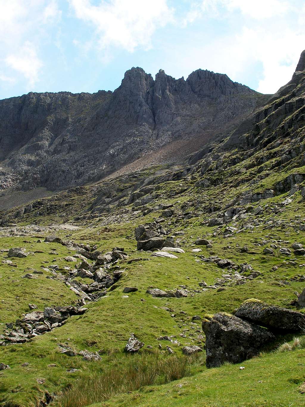
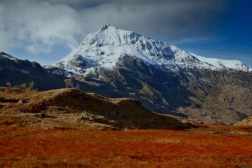
There can’t be many British climbers who haven’t heard tell of Crib Goch (923m); it has fascinated them for centuries. Its fame or perhaps, its notoriety, is even enough to make it well known to those who have little interest in climbing. However, for those less familiar with Britain’s mountains, maybe a short introduction is in order. Crib Goch, which literally means Red Ridge in Welsh, is one of Snowdon’s satellite peaks. Reaching a height of 3027 feet, it’s the 14th highest peak in Snowdonia and the 3rd highest of the Snowdon group itself, it’s therefore an immediately popular objective among peak baggers. What really makes it stand out though, is that it offers one of Britain’s quintessential ridge experiences; Scotland has the Carn Mor Dearg Arête, England has Striding Edge, but neither are as good as Crib Goch. For the most part, Crib Goch takes the form of a beautiful, bronzed, knife edge ridge, connecting the mountain’s summit with Wales’ second highest summit, Garnedd Ugain, and eventually, Snowdon itself. For those who wish to climb it, there is no straight forward route, it’s rocky and precipitous nature means, that at the very least, it’s a Grade 1 scramble all the way. A traverse of its spikes and spires is widely considered to be one of the best routes of the grade in the country, and when combined with a traverse of Y Lliwedd creates one of the finest mountain days anywhere - the Snowdon Horseshoe. Although under 1000m in height the dangers of climbing Crib Goch should not be underestimated, as almost every year somebody, usually the inexperience or ill prepared, dies on its slopes. If weather conditions are approaching the wrong side of harrowing, consider climbing something else, the mountain is best enjoyed in the sunshine anyway. |
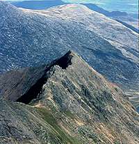
 Crib Goch Crib Goch(Photo by mtnbiker converted) |  Crib Goch Crib Goch(Photo by tphubard) |  Crib Goch Crib Goch(Photo by Bryan Benn) |
Routes
This section summarises some of the most popular routes on Crib Goch, for a more detailed description of the various routes available I recommend the following guidebooks:
Ridges of Snowdonia (Cicerone Guide) by Steve Ashton ScramblingThe Snowdon Horseshoe (Grade 1) This route is a classic mountain traverse and one of the finest mountaineering routes south of Scotland, incorporating the almost vertical knife edge of Crib Goch with scrambles on Crib y Ddysgl and Lliwedd and a visit of Snowdon's summit. The constituents of the route are briefly outlined below. East Ridge (Grade 1) This is the normal preliminary route on to Crib Goch's main ridge, and consists of easy scrambling up a blunt narrowing ridge directly to the summit of the peak. North Ridge (Grade 1) The cliffs of Dinas Mot give way to the long, gently rising North Ridge. Although the scrambling is not quite as enjoyable, this route makes for a much quieter alternative to the East Ridge, and joins said route at Crib Goch's summit. |
 Crib Goch Crib Goch(Photo by Ejnar Fjerdingstad) |  Crib Goch Crib Goch(Photo by Nanuls) |  East Ridge East Ridge(Photo by Nanuls) | 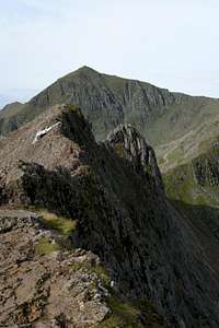 Crib Goch’s East Ridge Crib Goch’s East Ridge(Photo by stjepan) |
 Crib Goch Crib Goch(Photo by mtnbiker converted) |  Crib Goch Crib Goch(Photo by Nanuls) |  Crib Goch Crib Goch(Photo by munroitis) |
East Ridge (Grade I) This is the normal preliminary route on to Crib Goch's main ridge, and consists of easy scrambling up a blunt narrowing ridge directly to the summit of the peak, and in winter provides good mixed climbing. East Face (Grade I) An excellent choice as it is often in condition, this face is gained by traversing across from the PYG Track , or directly from Craig Cwm Beudy Mawr. The route offers a variety of lines on an Alpine like rockface, however care should be taken as rock fall is common particularly when the ridge above is busy.Crib Goch – Crib y Ddysgl Traverse (Grade I) The traverse consists of an exposed ridge walk over Crib Goch, a tricky section around the Pinnacles and an interesting ascent from Bwlch Goch onto Crib y Ddysgl. This is an exceptionally enjoyable section of the Snowdon Horseshoe. |

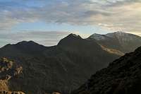
The Glyders from Clogwyn y Person, Snowdon. The mountains from left to right: Y Garn (947m), Pen-yr-Ole Wen (978m; background), Glyder Fawr (1,000m), Glyder Fach (994m), Crib Goch (923m) and Moel Siabod (872m; background)
(Photo by Nanuls)
(Photo by Nanuls)
|
Crib y Ddysgl – Crib Goch Traverse (Grade I) Although it is pretty much a simple reversal of the above route it contains an additional navigational hazard, with some climbers becoming confused and following the upper part of the Clogwyn Person Arete down into very steep and icy terrain. The true bearing onto Crib Goch runs east 105o magnetic. The following routs are found on the northwestern face of Crib Goch: Archer Thompson’s Route (Grade III 150m) Takes a shallow gully in the centre of the face left of Crib Goch Buttress. Carr’s Route (Grade III 150m) This route takes a shallow depression just left of Crib Goch Buttress. Crazy Pinnacle Gully (Grade II/III 100m) A short route that follows a deep gully situated between Crazy Pinnacle Buttress and the main crag. Easy snow climbing to begin with followed with the crux of the climb at the chockstone. |
 Crib Goch Crib Goch(Photo by Bryan Benn) |  Crib Goch Crib Goch(Photo by JoeHarris) |  Crib Goch Crib Goch(Photo by tphubbard) |
Mountain Conditions
ForecastThis section displays the mountain conditions for Snowdonia, of which Crib Goch is part. Click on the widget for maps and further information. This Snowdonia weather forecast is generated by the Met Office Weather Widget Web CamerasWebcams are a graet way of getting up-to-date weather information. Currently there are quite a few webcams in Snowdonia, only a few cameras located in the Snowdon area - even fewer are actually reliable. The section below provides links to the very best. These feeds are hosted by external sites, so obviously we can’t be held responsible if a camera happens to be malfunctioning. |
 Snowdon and Crib Goch Snowdon and Crib Goch(Photo by mills) |  Crib Goch Crib Goch(Photo by mills) |  Crib Goch Crib Goch(Photo by mtnbiker converted) |
When To Climb and Essential Gear
Most ascents are made during the spring and summer and during the high season the traverse can feel more like a bus queue than a mountain ascent. However, if one avoids weekends and public holidays, or employs some form of cunning route choice, a quiet day can be had . The area is often cloudy and showers are frequent so full waterproofs are always essential no matter what the weather forecast. A good pare of boots, a map, a compass and a hat are also a necessity. Most scrambles can be done with no more extra gear than one might carry for a hike, but for the harder routes, some may choose to carry a helmet, rope, harness and a small rack of slings, crabs and nuts. The best time for rock climbing is from late spring to early autumn, when there is little chance of snow and ice and the crags dry out much more quickly. For the long, multi-pitch routes, a reasonable sized rack will probably be necessary. Most routes will require half ropes of 50 metres length, though on the longer, easier routes, a single rope will probably suffice. It’s worth emphasising that the crags on Snowdon are big, serious and vulnerable to the area’s fickle climate so be sure to carry enough food, water and warm, waterproof clothing. On the longer and/or less accessible routes, a headtorch may prove to be a very handy piece of kit; this is even truer in winter. When snow and ice is likely, ice axe and crampons should be carried. For true winter routes, specialist winter and ice climbing equipment is necessary and owing to the unpredictable nature of the mountain’s snow and ice, these lines should only be attempted by those with experience of winter mountaineering techniques. Despite Snowdon’s comparatively low altitude winters can be very cold, with temperatures dropping to Arctic levels; many inexperienced walkers and climbers have been caught out in these conditions, most are rescued by mountain rescue teams however, on occasion, the consequences are much more serious. |

Crib Goch (Photo by Nanuls)
Red Tape and Access
No red tape here! For climbers, hill walkers and mountaineers, the British Mountaineering Council (BMC) runs a Regional Access Database, which holds mountain/crag specific information on matters of conservation and access, including issues such as nesting restrictions, nature designations and preferred parking. If you are in any doubt about any particular access arrangement, or need to report an incident, you should contact your local BMC Access Representative or the BMC Access Officers for Wales: Elfyn Jones. |
Getting There
The most common starting point for Crib Goch is the Pen y Pass car park (SH 647 555), at the zenith of Llanberis Pass, which can be reached easily by road on the A4086 that runs between Llanberis (SH 582 598) and Capel Curig (SH 719 580). Owing to the popularity of the route the Pen y Pass car park often fills up quickly so if you want to park there a very early start is recommended. Luckily there are other options, the first of these is an excellent park and ride which runs regularly all day (including weekends and bank holidays) from Nant Perris (SH 607 582). The second option is the Snowdon Sherpa bus service which has various stops around the mountain and runs from Llanberis, Bettws y Coed, Caernarfon, Beddgelert, Bethesda and Porthmadog. Be sure to check timetables first as you don't want to end up missing the last bus and find yourself stuck, of course in these situations hitching is always an option. |
 Llanberis from Crib Goch Llanberis from Crib Goch(Photo by mills) |  Snowdon and Crib Goch Snowdon and Crib Goch(Photo by mills) |  Crib Goch Crib Goch(Photo by AndyWhaley) |
Accommodation and Camping
There are several campsites around the area, including Beddgelert Forest, Cae Du, The Cwellyn Arms, Garth Farm, Bryn Gloch Caravan & Camping Park and Ynys Ettws, although none (with the exception of Ynys Ettws) are exceptionally close to Crib Goch. There are also a number of YHA hostels in the area, the nearest of which is the Pen-y-Pass hostel, a short walk from the base of the mountain. The Plas y Brenin National Mountain Centre in Capel Curig also has a bunk house, and has its own indoor climbing wall if you still feel energetic after your day on the mountain. Also the nearby towns of Capel Curig, Llanberis and Beddgelert all have various hotels, hostels, B&Bs and campsites. |
Maps
Guidebooks


External Links
 Crib Goch (Photo by mills) Crib Goch (Photo by mills) Crib Goch (Photo by Trevers89) Crib Goch (Photo by Trevers89)Government Bodies and Official Organisations Snowdonia National Park Authority Association of National Park Authorities Royal Commission on Ancient & Historical Monuments in Wales Hiking, Climbing and Mountaineering Organisations and Companies British Mountaineering Council Plas y Brenin National Mountain Centre Weather Tourist Information North Wales Tourism Partnership Local Information from Gwynedd.com Local Information from Snowdonia Wales Net Travel Welsh Public Transport Information Accommodation Youth Hostel Association in Wales Maps and Guidebooks Cordee Travel and Adventure Sports Bookshop Wildlife and Conservation |