
|
|
Mountain/Rock |
|---|---|
|
|
52.98410°N / 3.99984°W |
|
|
Gwynedd |
|
|
Hiking, Mountaineering, Scrambling |
|
|
Spring, Summer, Fall, Winter |
|
|
2526 ft / 770 m |
|
|
Overview
Despite its somewhat assuming title, Moelwyn Mawr (Big White Bare Hill in Welsh) isn’t the biggest mountain in the Moelwynion (Bare White Hills); that honour goes to Moel Siabod, which is located some way to its north. There appears to be a tendency for this kind of misnaming in Snowdonia; perhaps a result of the inability of the area’s early inhabitants to accurately measure their surroundings, as is indicated by Defoe’s above quote. This shouldn’t detract from its appeal however, as Moelwyn Mawr is one of the range’s finest little peaks, with a summit that affords spectacular views in every direction. While the mountain itself offers northing in the form of rock climbing, though it can be found nearby, a walk to the summit provides one of the most interesting hikes in the region. Whether starting from Cwm Croesor or the Vale of Ffestiniog, one will pass the ruins of a once bustling slate industry. Adits, shafts, quarries, buildings and tramlines abound, and in places, the detritus of these activities has been built up to form rising terraces of slate along the hillsides, which may momentarily, give the impression that the mountains were once occupied by some Mesoamerican civilisation, rather than subjugated Welsh quarrymen. The mountain is best climbed in combination with some of the localities other peaks. If starting in Cwm Croeso, then a horseshoe of said Cwm can be made by including Cnicht in the walk. If starting from Tanygrisiau, then including Moelwyn Bach by means of Craigysgafn, makes another good horseshoe, this time, around the mountain’s dammed lake, Llyn Stwlan. There’s much to explore here, just make sure that you don’t disappear down some hole, it’s a maze down there – you may never come out! |
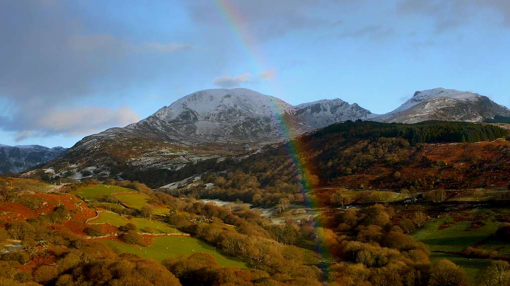
Moelwyn Bach (left) and Moelwyn Mawr (right) (Photo by mills)
Mountain Conditions
This section displays the mountain conditions for Snowdonia, of which Moelwyn Mawr is a part. Click on the widget for maps and further information. This Snowdonia weather forecast is generated by the Met Office Weather Widget |
When to Climb and Essential Gear
Moelwyn Mawr can be climbed at anytime of the year, however in poor conditions the mountain may be best avoided. April to September offer the most reliable conditions and one will need all the equipment one usually carries for a day in the mountains, which in Wales means full waterproofs and sturdy boots as a minimum. If you’re lucky enough to climb the mountain in winter conditions then an ice axe and crampons would be very useful. |
Getting There
Moelwyn Mawr is located in the southern Moelwynion, between the valleys of Cwm Croesor in the west and the Vale of Ffestiniog in the east. The mountain can be approached from either of these valleys, both giving an interesting walk in. Cwm Croesor may only be reached from the south. If you’re coming from the east therefore, leave the A487 in Penrhyndeudraeth (SH 611 389) and take the A4085 north in the direction of Beddgelert (SH 590 481). Just after the village of Garreg (SH 612 416), there is a right hand turn (SH 614 420), which is signposted for the village of Croesor (SH 630 447). The village is reached after around 3km. Park in the small National Park run car park in the village. If you’d rather start your walk from the Vale of Ffestiniog, the most convenient starting point is the small car park just above the village of Tanygrisiau. To reach it, leave the A470 at the roundabout in Blaenau Ffestiniog (SH 697 460) and take the A496 in a southerly direction over the railway line. Continue along the A496 for a kilometre or so to a small junction on the right hand side (SH 688 448). Take this junction and then turn left immediately, following the signs for the Ffestiniog Power Station; 500 metres down the road there’s a café on the left hand side; it’s a great place to start and end a day in the hills. Pass the café and follow the curving road up the hill to the car park at the top of Tanygrisiau (SH 683 453). |
 Moelwyn Mawr Moelwyn Mawr(Photo by Bryan Benn) |  Moelwyn Mawr Moelwyn Mawr(Photo by daveyboy) |  Moelwynion Moelwynion(Photo by Bryan Benn) |
Red Tape and Access
No red tape or access issues here! For climbers, hill walkers and mountaineers, the British Mountaineering Council (BMC) runs a Regional Access Database, which holds mountain/crag specific information on matters of conservation and access, including issues such as nesting restrictions, nature designations and preferred parking: If you are in any doubt about any particular access arrangement, or need to report an incident, you should contact your local BMC Access Representative or the BMC Access Officers for Wales: Elfyn Jones. |


Camping and Accommodation
There’s an almost unlimited supply of accommodation within the Snowdonia National Park so it would be inappropriate to list it all here. For budget accommodation it’s worth checking out some of the following sites: Youth Hostel Association in WalesIndependent Hostel GuideCampsites in Gwynedd |
Maps
Guidebooks
|
|


External Links
 Llyn Stwlan (Photo by Nanuls Llyn Stwlan (Photo by Nanuls Craigysgafn (Photo by daveyboy) Craigysgafn (Photo by daveyboy) Moelwynion (Photo by daveyboy) Moelwynion (Photo by daveyboy) Moelwyn Mawr (Photo by daveyboy) Moelwyn Mawr (Photo by daveyboy)Government Bodies and Official Organisations Snowdonia National Park Authority Association of National Park Authorities Royal Commission on Ancient & Historical Monuments in Wales Hiking, Climbing and Mountaineering Organisations and Companies British Mountaineering Council Plas y Brenin National Mountain Centre Weather Tourist Information North Wales Tourism Partnership Local Information from Gwynedd.com Local Information from Snowdonia Wales Net Travel Welsh Public Transport Information Accommodation Youth Hostel Association in Wales Maps and Guidebooks Cordee Travel and Adventure Sports Bookshop Wildlife and Conservation |
visentin - Jan 24, 2011 2:55 pm - Voted 10/10
still...taking straight to the red tape :D good luck in your research ;)
Nanuls - Jan 24, 2011 5:42 pm - Hasn't voted
Re: still...Arg! On we go...
Nanuls - Jan 25, 2011 5:23 am - Hasn't voted
Re: still...Hey Eric, still trying to work things out! How does it work now?
visentin - Jan 25, 2011 5:46 am - Voted 10/10
Re: still...same :( Pity, because it takes people out of the place where we can vote ! :) Why dont you try installing firefox, and test by removing each chapter one by one to find the reason ?
Nanuls - Jan 25, 2011 10:16 am - Hasn't voted
Re: still...Arses! It's not what I thought the problem was. This may take some time. At the moment I can only use my work laptop, which I can't install software on (inc. Firefox... obviously), which is why I was asking you guys for help (thanks very much by the way!). I think I will wait now until my own computers back online and play with it then. All my pages look just fine on IE by the way - who'd have thought it?!
visentin - Jan 25, 2011 10:36 am - Voted 10/10
Re: still...Why not testing with Netscape ? :)
Nanuls - Jan 25, 2011 11:22 am - Hasn't voted
Re: still...Ha ha! Even if I wanted to I couldn't!