Introduction
![Pretty Vistas]() Spectacular Vistas on Trail
Spectacular Vistas on Trail![Primitive Trail]() Primitive Trail
Primitive Trail
Some accomplishments are of such grand magnitude they demand they be chronicled. Bagging K2 without oxygen. Bagging Pippi Middleton without title. Bagging Arches National Park Devil’s Garden without seeing another soul the entire 7.2 mile hike. If you do it, you have to tell the world.
Of the three accomplishments, soloing Devil’s Garden hike is probably the rarest. The national park, located near Moab Utah, gets well over 1 million visitors a year and Devil’s Garden is justifiably one of the park’s most popular hikes. Huge crowds swarm toward the main attractions and students of human studies will note the entire spectrum of mankind on the trails. Rotund, flip-flop shod Americans. Shirtless foreigners from every corner of the planet. Exotic potentates. Screaming/whining/I-want-my-video-game children. Hippies. You name them, they are there! All of which conspire to turn your spiritual commune into a Nature-as-a-Theme-Park humbug. You’ve got to see Arches, but you’ve got to see it alone.
Despair not! Nicky Machiavelli once noted that “all men, in general, are fickle, cowardly and irresolute”. Hikers seeking Arches solitude can use these traits to their advantage by simply timing their hike to when the fickle, cowardly and irresolute are somewhere else. Based on my extensive analysis, the optimal time to A: See the Devil’s Garden in HD, bright-light sunshine and B: Avoid any human contact, is to start your “tour de Devils Garden” hike at Sunrise (approx 0700) in late February/early March. I have also concluded solitude seekers can try Arches any mid-week day October thru April with a fair chance of seeing it alone. Don’t worry about the park being closed, it’s open 24/7.
The Devil’s Garden/Primitive Loop Trail is the longest maintained trail in Arches National Park and is about 7.2 miles long including all side trails. Hiking the Garden takes around 5 leisurely hours including time for contemplation and photo ops. The main attractions (other than the spectacular desert landscapes every step of the way) are Landscape, Navajo, Double O, and Private Arches, plus Dark Angel Obelisk. The trail is well maintained and marked by cairns. The signs for Primitive Trail say it is difficult and dangerous, but it didn’t seem much different than the trail to Double O Arch and Dark Angel. In fact, Primitive Trail actually seemed easier because I don’t like heights much and wasn’t too jazzed climbing the fins on Double O Arch trail.
The Hike
![Dark Angel]() Dark Angel
Dark Angel![Primitive Trail Canyon]() Boxed canyons along trail
Boxed canyons along trail
The Landscape Arch Trailhead is at the North end of the park at the end of the road about 18 miles from the park’s entrance. It has a fairly big parking lot that is empty in the mornings but fills up by early afternoon. If you show up late, you have to park in the overflow area and hike to the hike. The trailhead has an outhouse toilet and water available. They sell trail maps for $.50 but the info isn’t much better than what you get when you enter the park. There is only one trail off of the trail head and it heads toward Landscape Arch.
The first segment of the hike is toward Landscape Arch through a narrow canyon and into the desert. Landscape Arch is .8 miles away from the trailhead and is the sole destination and turn around point for at least half of the tourists. Immediately before Landscape, the trail splits with the sign directing you toward Landscape or onto Primitive Trail.
If you had an empty parking lot when you started, your best chance to avoid crowds is to continue toward Landscape/Double O Arch trails. If you go the Primitive Trail direction, you’ll encounter the Landscape crowds on the tail end of your loop; if you continue toward Landscape, you’ll be ahead of the crowd and see all the sights without the people.
After Landscape, the trail goes up a slick rock fin. At the top, signs direct you toward Navajo, Partition, or Double O arches. Navajo and Partition are side trails; neat to look at and worth the detour. Pressing on toward Double O, you again climb another set of fins that are about 8 foot wide with a 30 foot drop to the left and a 100 foot drop off to your right…no problem unless you hate heights!
Follow the cairns and trail 2.1 miles total to Double O Arch and take some iconic photos. Double O Arch is the final destination for about 90% of the trail’s causal hikers and they return to the trailhead the way they came. From Double O you can see Dark Angel Obelisk .5 miles away. Follow the trail, take a break at the base of the Obelisk, and retrace your path back to Double O where the signs direct you to Primitive Trail.
Primitive Trail is marginally less well maintained than the Double O Arch trail. As it drops down into a canyon the trail disappears on numerous occasions. Keep your eyes peeled for marker cairns along the way. Some of the routing isn’t intuitive and it is possible to lose the trail. For more adventurous hikers, go up the slick rocks or explore the box canyons along the route. You’ll also pass Private Arch which is a .3 mile detour (one way) to reach. Private Arch isn’t the biggest arch in the park but it is pretty isolated and you’ll most likely have the place to yourself. As you continue through Primitive Trail Canyon, you’ll bottom out in a wash. During rainy periods and winter this area may force detours as it would be filled with water. After bottoming out, the trail passes a sign and again climbs, turning into a rocky desert until it reaches the Landscape Arch cross road. From here, follow the trail back to your car to complete the hike.
Safety
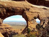
![Partition Arch]() Partition Arch
Partition Arch![Hiking the Fins]() Hiking the Fins
Hiking the Fins
Even though Arches is a National Park, safety can still be a concern. First and most obvious, it gets hot. Real hot. 100+ degree hot. If you go during the summer, the Rangers recommend you bring at least a gallon of water per person. Don’t worry about the weight, you’ll drink most of it during the loop. Also inherent to hot weather hiking, wear long sleeves if possible, use copious amounts of sunscreen, hats are great protection, and sunglasses are a must. Slick rock is, by definition, slick…wear proper shoes with decent grip. Finally, cell phone coverage is iffy at best especially in the canyons. Don’t rely on it to provide rescue and know where you are going before you go.
Camping
![Bottom of Primitive Trail Canyon]() Canyon Wash
Canyon Wash
While Moab has a herd of reasonably priced hotels built for the express purpose of supporting Arches/Canyonlands expeditions, some hardy (or cheap) individuals may prefer to camp. There is one campground , located near Devil's Garden (cleverly named "Devils Garden Campground). It is an extremely popular site and is usually booked up from May – August. The campground includes potable water, picnic tables, grills (bring your own wood/charcoal) and toilets. They don’t have showers. You can make reservations online at recreation.gov. You can also “backcountry” camp, but you have to get a permit from the NPS at the Visitor Center.
PHOTO CREDIT: Title Picture of Landscape Arch
By TLEAF


Comments
Post a Comment