
|
|
Area/Range |
|---|---|
|
|
38.70800°N / 109.563°W |
|
|
Hiking, Trad Climbing, Aid Climbing, Scrambling, Canyoneering |
|
|
Spring, Summer, Fall, Winter |
|
|
5000 ft / 1524 m |
|
|
This page is up for adoption
Let me know if you'd like to have this page. Just send me a message. Update about this page:
Those of you who click on this page expecting to see Aaron's name at the top are probably a bit surprised to see mine. When he offered me the page, I balked since he has lovingly crafted what I call a "mona lisa" quality page and there was no way I could ever replicate what he had put together. Fortunately, he listened and was kind enough to leave the material up for the rest of you to enjoy. I will do some changing but nothing I will do will be done to detract from what he and Radek put together. Any future votes on this page will only reflect appreciation for the work Aaron has done and will have very little reflection on what I have contributed. Thanks to the originators of this page for all the work and effort it took to create it. I hope the rest of the SP community will also realize the great loss when quality members leave our ranks for whatever reason. As for me, I can only say: Thank you.
While not part of Arches, the Fisher Towers complex is nearby and this recent trip report by pellucid wombat is really a grabber. Check it out here.
Overview
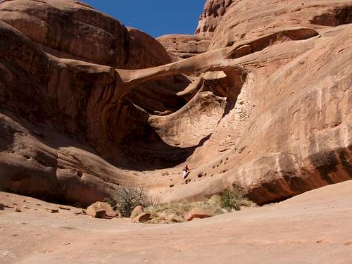
Once a visitor steps into Arches National Park, they might as well set foot on another planet. This park, considered by many to be the gem of the Park System, is a special place indeed. Few places on earth can compare to it. It is home to erosion anomalies called arches, where wind and water have carved incredible formations out of the fragile Entrada sandstone that dominates the high plateau the park occupies. Arches National Park has the greatest concentration of these natural wonders on the planet. Over 2,000 arches are cataloged from the minimum qualifier of 3 feet to 306 feet.
While very popular with casual tourists from around the world, Arches is a park for hikers and climbers, and is therefore of special interest to SummitPost members. Outstanding hiking opportunities abound, and the technical climbing routes in Arches are well known, offering a wide variety of challenges and discovery. SummitPost is blessed to have the best of both worlds presented here, thus offering the most comprehensive and evolving source of hiking and climbing information on this spectacular, spiritual place.
CONTRIBUTORS: If you've climbed some routes, or hiked some trails not yet displayed here, please feel free to contribute! We currently have an impressive line up of material (see left side bar of links to further material), so be sure to check them out. There's lots of information and views there not available anywhere else!
PHOTO CONTRIBUTORS: The image section of this page is full of duplicate shots, particularly of Delicate Arch. It is the intent of this effort to show the less predictable and less seen areas of Arches, as the more common shots can be seen anywhere (see above statement under "contributors"). Please refrain from adding common scenes. Duplicated shots will be lost among the 300+ (and counting) images, and will likely never see display on this page. If your pictures illustrate a new area or route, by all means please add them with a good caption and they might be featured in the future. Thanks!
THIS PAGE IS BEST VIEWED ON A WIDESCREEN MONITOR, APPROXIMATELY 1280 x 760
Getting There
From Grand Junction, go west on Interstate 70 to the first Cisco exit. The road passes under the highway, and parallels the interstate briefly before coming to the ghostly hamlet of Cisco. Beyond is a left turn onto Scenic Drive Highway 128, which will take you through the scenic Castle Valley, and to Moab and Arches. The challenge is to keep your eyes on the road! At the junction with Highway 191, turn right to go to Arches, turn left to go to Moab.
From the Crescent Junction interchange on Interstate 70, head south on Highway 191 approximately 30 miles to Moab. The entrance to Arches will be on your left prior to arriving at Moab.
If approaching from the south, simply head north on Highway 191 to Moab. Arches is 5 miles north of town.
Red Tape
DON’T SPOIL THE SOIL!
Much of the SE Utah desert including the Arches National Park is home to Cryptobiotic Soil Crust. Watch where you step as this stuff is extremely sensitive and this “stuff” is also what’s keeping erosion at bay on hillsides. The NPS recommends using established trails, sandstone slabs, and/or sandy washes for your foot travel throughout the park.
SPECIAL ANNOUNCEMENT-EFFECTIVE MAY 9, 2006:
Effective May 9, 2006, under the authority of Title 36 Code of Federal Regulations (CFR), Part 1, Section 1.5(a)(1), all rock climbing or similar activities on any arch or natural bridge named on the United States Geological Survey 7.5 minute topographical maps covering Arches National Park are prohibited. In addition, slacklining in Arches National Park is prohibited. Slacklining is defined as walking on a rope or other line that is anchored between rock formations, trees, or any other natural features. Height of the rope above the ground is immaterial.
These closures are based upon a determination that such action is necessary for the maintenance of public health and safety, protection of environmental or scenic values, protection of natural resources and avoidance of conflict among visitor use activities.
Contacts for further information concerning this announcement:
Laura Joss, 435-719-2201
Karen McKinlay-Jones, 435-719-2222
ADDITIONAL CLIMBING REGULATIONS:
- bolting is prohibited (except to replace mank)
- no use of hammer (routes must go clean)
- chalk should be colored
SummitPost Discussion
Pets are only allowed on Park roads and must be physically restrained at all times. Pets are not permitted on or off trails, in the backcountry, or in Park buildings. Pets left in vehicles during the day can die quickly of heat exhaustion.
Mountain bikes are allowed on established roads and 4WD roads. They are not permitted on trails or in the backcountry.
Hunting and firearms are not permitted.
All features are protected. All Federal and State laws are strictly enforced in the Park.
Camping
Camping accommodations are available in the north end of the park at the Devils Garden Campground, located at the terminus of the road that accesses most of the Park’s attractions. This camping area is popular and usually full most of the spring and summer. Picnic tables, restrooms and water are available. 52 camp sites host tents to trailers and available on a first come, first serve basis. Two walk-in group tent sites that host up to 11 people are available for reservation. Campfire programs are offered at the nearby amphitheater. A fee is charged year round to take advantage of these facilities.
For group camp site reservations, write Reservation Office, Southeast Utah Group, National Park Service, 2282 S. West Resource Boulevard, Moab, Utah, 84532 or FAX to 435-259-4285.
Backcountry camping is permitted. Those wishing to camp overnight in the wilds must secure a free permit at the Visitor Center at the park entrance. There are no designated backcountry trails or campsites. You’ll be asked where you plan on setting your camp. Low impact practices are essential, and you must provide all of your water. No open fires are allowed.
Wood gathering is not permitted. Bring fuel for provided grills or a camping stove for backcountry camping.
There are no lodging facilities within the Park.
When to Visit Arches
Summer: Temperatures can reach 110 degrees. Carry at least 1 gallon of water per person per day.
Fall & Spring: Temperatures are more mild. Thunderstorms may be a factor in your plans during the spring and early summer. In addition to rain, snow storms may figure into your activities in the fall. Even so, these are the best times to visit Arches.
Winter: This is the high desert, and it does get cold at Arches, and it does snow, which can make for great photo opportunities! Most snow melts quickly, though. This is the quiet time at Arches, but be sure to be dressed for the occasion.
Current Moab NOAA Weather
Area Webcam Near Arches
Essentials
Depending on the scope of your visit, you will need the following:
Bring plenty of water! This cannot be emphasized enough.
Food, topographic map for backcountry outings, or at the minimum, a Park map for orientation purposes. Sunscreen and hat! Extra clothing and good hiking boots with good tread for slickrock hiking. Worn soles can lead to injury or worse.
Make sure your 4WD vehicle is in good condition before going into the backcountry. Experience in desert 4WD activities is a good idea. Expect slickrock, deep sand and slippery conditions after rain or snow storms.
Consult the gear sections on the climbing routes for gear specifics.
What To Do
VISITOR CENTER
The Visitor Center was recently redesigned to great effect and the interpretive displays are outstanding. An excellent multimedia program is run regularly and should not be missed. Plenty of educational and scenic material is available, and the Park staff will have the answers to your questions. A booklet or audio tour for the main Park road is available, as is a guide to the trails of the Park. The gift shop is outstanding as well.
DRIVING
Most of Arches’ well known attractions can be seen with a brief drive and a bit of walking. Plan on stopping and getting out often. It is impossible to truly enjoy the spirit of the Park from behind your steering wheel. Short hikes to most of the attractions will make for a pleasant but quick visit to the Park.
PHOTOGRAPHY
It goes without sayng that Arches is a photographer's paradise. Some of the world's most notable pictures have been taken at Arches, and some of the best photography on SummitPost was done here, and proudly displayed on this page.
BICYCLING & FOUR WHEELING
The Park has some 4WD roads that are not difficult and are enjoyable for bicycling. The roads are easy for 4WD vehicles in dry conditions, but can become a challenge in wet conditions. Access to Tower Arch and Klondike Bluffs is provided via the Salt Valley 4WD road, and is worth the time and effort. It is recommended that the Salt Valley road be traveled north to south due to sandy conditions. The Willow Flats road leads to the west border of the Park and provides southern access to Herdina Park. A crossing may often be impassable, so check with the rangers at the Visitor Center before you proceed.
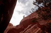
HIKING
Arches is a hiking paradise! Plenty of options are available (see hiking trails section below), ranging from short hikes at less than a mile, to the Primitive Trail, a 7 mile loop. There's plenty of activities to keep kids occupied as well.
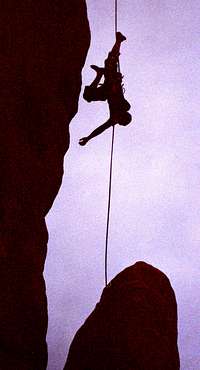
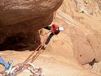
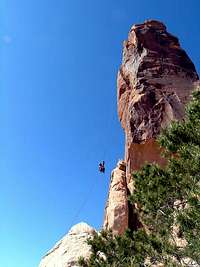
CLIMBING
Some of the best and most renowned technical climbing routes are to be found in Arches National Park, and SummitPost has a growing collection of them in excellent detail. (See the climbing section below).
CANYONEERING
Numerous canyoneering objectives are available within the Park and nearby. Be sure to check out the new canyoneering section on this page.


Hiking Trails Overview
PARK AVENUE 1 mile, one way
Easy canyon stroll between canyon walls and balanced rocks. Popular technical climbs start nearby. Great introduction to hiking in Arches.


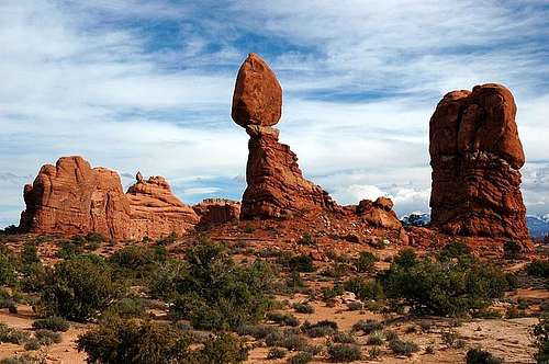
BALANCED ROCK 1/3 mile loop
An easy stroll around the base of Balanced Rock, this trail is popular with tourists.
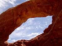
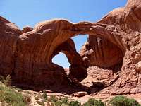
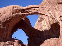
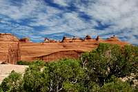
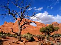
THE WINDOWS 1 mile loop or more
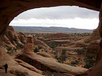
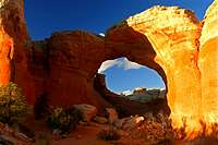
Perhaps the most popular part of the Park, the area nonetheless deserves your time. Visit the massive North and South Windows, as well as towering Turret Arch, some of the biggest arch formations in the Park.
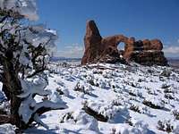 Winter Spectacle |
 Windows Section |
 Parade of Elephants</a > |
 Turret Arch |
|---|---|---|---|
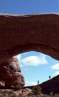 North Window |
 Turret Arch |
 Elephant Butte |
 South Window |
DOUBLE ARCH .8 mile
This formation just gets bigger and bigger as you approach it and is definitely worth a visit.

GARDEN OF EDEN
Plenty of rock towers and goblin formations dot this area, which is a great spot to explore or relax. No definitive trails are here, so opportunities for discovery are endless.


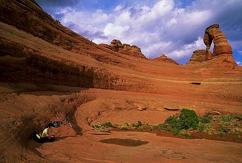
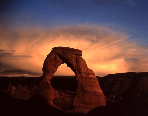
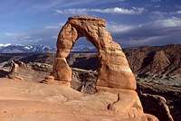
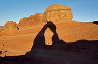
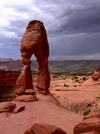
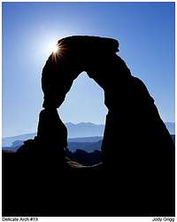
DELICATE ARCH 3 mile round trip
A cairned trail climbs a slickrock tilted plateau for a gain of 480 feet. Ledges and exposure lead past two window arches to a dramatic encounter with the world’s most popular arch. Best at sunset, but sunrise is nice, too. Be sure to take plenty of water, and a layer of clothing for temperature changes. Delicate Arch Viewpoint is a wheel chair accessible viewing spot of the arch, accessed by a short drive from the Delicate Arch trailhead.
 Evening Light |
 Fantastic Photo Ops |
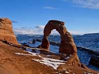 Winter Splendor</a > |
 Delicate Wonder |
|---|---|---|---|
 Good From Any Angle |
 Sun Show |
 Sunset Shadow |
 Precipice Vantage |
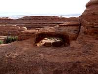
SAN DUNE ARCH .3 mile
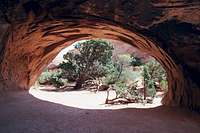
BROKEN ARCH 1.3 miles round trip
Great for kids, amazing for adults. A sand dune between two rock fins beneath a secluded arch provides a shady, otherworld respite. For Broken Arch, stroll across grassland to this secluded wonder with great views and fun scrambling opportunities.


SKYLINE ARCH .4 mile round trip
Usually seen from the highway, this arch is much more impressive up close and personal. A piece of rock fell out of this arch in the 50’s, making it 40% larger.


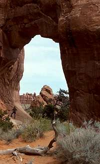
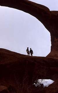
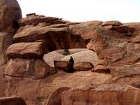
LANDSCAPE ARCH 1.6 miles round trip from Devils Garden, plus additional attractions
This is the world’s longest arch span, and also one of the oldest. A primitive trail used to wind underneath the arch, but it has since been closed since a 60 foot long piece of the arch, 11 feet wide and 4 feet thick, fell onto the trail area below in 1991. Best photographed in the morning. Nearby Tunnel and Pine Tree arches are worthy side trips. Partition Arch is just north of Landscape Arch and is also worth a trip. Secluded Navajo Arch is another side trip along the Devils Garden trail that is worth your time.
 Landscape Arch |
 Rare View |
 Wall Arch R.I.P.</a > |
 Partition Arch |
|---|---|---|---|
 Pine Tree Arch |
 Tunnel Arch |
 Navajo Arch |
 Devils Garden |
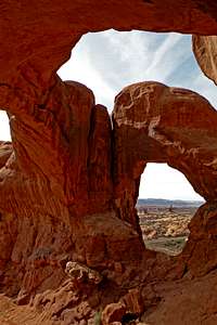
DOUBLE-O ARCH 4.2 miles round trip
This hike is best executed in cooler conditions. The route is intriguing and fun, but plenty of exposure on the tops of rock fins is encountered. Good hiking boots are essential, and don’t forget plenty of water. This arch is a big one on top of a little one. A tower of stone called Dark Angel is located beyond and is a climbing objective.


PRIMITIVE LOOP TRAIL 7 mile round trip from Devils Garden
Take in all of the above stops, and from Double-O Arch, proceed into the arches backcountry for a fun hike and scramble to some of the remote reaches of the Park. Discover Private and Black Arches, emerge back at Pine Tree Arch. This route is highly recommended for experienced desert hikers. Plan on at least half the day for this trip.
 Arches Backcountry |
 Restaurant Arch West Side |
 Restaurant Arch East Side |
|---|---|---|
 Desert Solitude |
 Complex Terrain |
 Black Arch |
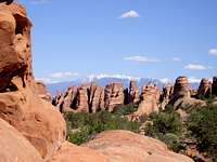
TOWER ARCH & KLONDIKE BLUFFS 3.4 miles round trip from the eastern access 4WD road.
This hidden wonder is one of Utah’s largest arches, and is reached via a wandering trail that gives hikers a great tour of the complex Klondike Bluffs formation.
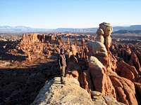 Spectacular Region |
 Gigantic Tower Arch |
 Unique Towers</a > |
 Exploration Beckons |
|---|---|---|---|
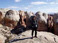 Marching Men |
 Approaching the Marching Men |
 Main Attraction |
 Nice View |
THE FIERY FURNACE
This incredible formation defies accurate mapping, and is so complex that guided tours are offered. Unguided visits are possible by obtaining a permit at the Visitor Center, but people are often rescued after getting lost or marooned on a ledge or fin because of their lack of knowledge about the Fiery Furnace. There are two versions of the guided tour, both are excellent, different and recommended. One tour lasts 90 minutes, the other is almost 3 hours long. Reservations are required at the Visitor Center. Expect plenty of scrambling through narrow slots and over boulders, ledges and fins. Good tread on hiking boots is essential, along with plenty of water. Expect to get dirty! Temperatures change rapidly, so a layer of clothing such as a jacket is recommended for shady spots, but rest assured temperatures can be roasting. They don’t call it the Fiery Furnace for nothing. You’ll see the world’s smallest arch, the Porkchop, as well as the intriguing Skull Arch and much more. Not to be missed!
 Get Dirty! |
 Tours Recommended! |
 Maze of Rock</a > |
 Surprise Arch |
|---|---|---|---|
 Forget The Map! |
 Skull Arch |
 Late Day Splendor |
 Hiker's Paradise |
HERDINA PARK
Perhaps the most remote section of the Park, Herdina Park is situated in the west end of Arches and features a maze like network of canyons that provide a significant navigation challenge as well as several arches rarely seen in any media. The region is reached via dirt roads of varying difficulty, so a high clearance vehicle, preferably equipped with four wheel drive is recommended, which no doubt explains why this location remains largely unexplored by casual tourists. For desert loving hikers and exploring enthusiasts, Herdina Park offers plenty of challenges and opportunities for discovery.
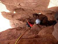
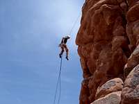
Climbing Routes Overview
Overviews of routes will be featured in this section if an accompanying Mountain/Rock or Route page has been attached to this page. There are plenty of climbing photos in the IMAGES section that have been submitted without accompanying route descriptions. Please notify us if these additions are made and we'll feature them in this section as well.


List of routes and formations below is organized in (roughly) the order one would encounter them while driving through the park. Starting with the Three Penguins that tower above the visitors' center, moving on to the Courthouse Buttes cluster (Tower Of Babel, etc), followed by a side trip to the Windows Arch area (Owl Rock and Elephant Butte), and finally ending the trip at the Devils Garden trailhead and its Dark Angel.
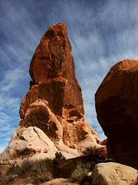
THREE PENGUINS
Three Penguins
The Right Chimney II 5.10


TOWER OF BABEL: ZENYATTA ENTRADA
Tower Of Babel
Zenyatta Entrada IV 5.8+ C3+


ARGON TOWER
Argon Tower
West Face II 5.9+ C1 or 5.11+


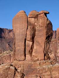
THREE GOSSIPS
Three Gossips
West Face (North Gossip) II 5.10 C1 or 5.11
Be There Or Be Talked About (South Gossip) II 5.9 C1 or 5.11 A0


SHEEP ROCK
Sheep Rock
Virgin Wool III 5.10- C2+


ELEPHANT BUTTE
Elephant Butte
West Fins 5.4


BULLWINKLE TOWER
Bullwinkle Tower
West Chimney 5.7
OWL ROCK
Owl Rock
Olevsky Route 5.8


DARK ANGEL
Dark Angel
West Face 5.9 A0


Canyon Routes
Dragonfly Canyon, Upper and Lower Courthouse Washes and several other options offer opportunities for discovery and adventure. Click on the photos below for some enticing information. As more information is added to this page, so this section will expand.


A Brief History of Arches
A salt bed thousands of feet thick was deposited on the Colorado Plateau around 300 million years ago by an ancient sea. Following the sea’s evaporation over millions of years, the bed was covered with residue from floods and winds, much of which was compressed into rock, which at one time may have been a mile thick. The salt beneath this weight became unstable, shifted and buckled. Rock layers were thrust upward into domes, other layers fell into cavities. A 2,500 foot fault displacement, known as the Moab fault produced vertical cracks and erosion stripped away some rock layers. Most of this rock is known today as the Entrada sandstone formation, in which most of the arches are formed. Water seeped into the cracks and freezing and thawing had an impact as well. Wind would later clean out the loose particles and fins were formed. The elements whittled away at the weaker rock, chunks of rock tumbled out and many fins collapsed. Stronger fins remained, and the weaknesses gave way to the formation of arches.
Native Americans frequented the area for thousands of years in search of game and wild plant foods, and stone for tools and weapons. Evidence of their presence are petroglyph panels, one of which is found near the beginning of the Delicate Arch trail. The first European explorers were Spaniards, and the Old Santa Fe trail is the same route Highway 191 follows today as it passes the Visitor Center. White explorers seeking minerals and ranchers seeking grasses for their livestock followed. Mormon settlers established what would later become Moab in 1855. Conflicts with the Ute tribe of Native Americans delayed the permanent settlement, which finally occurred in the 1890s.
President Herbert Hoover signed legislation creating Arches National Monument in 1929. Congress changed the status to a National Park in 1971.
More Information


Additional Links
GENERAL
Aches National Park
Moab Chamber of Commerce
RELATED SUMMITPOST MOUNTAIN PAGES
La Sal Mountains
Overview of the nearby La Sal Mountain Range
Mount Tukuhnikivatz
Mount Peale
Manns Peak
Mount Waas
Mount Mellenthin
Mount Tomasaki
Pilot Mountain
OTHER OUTSTANDING SUMMITPOST PAGES & ATTRACTIONS
Canyonlands National Park
The Needles
The Maze
The Priest
Sister Superior Group
Lighthouse Tower
The Rectory
Fisher Towers/Onion Creek Towers
Adobe Mesa
Castleton Tower
Professor Creek
The Hindu
Thompson Canyon
Dead Horse Point State Park
Capitol Reef National Park
San Rafael Swell
Goblin Valley
Grand Staircase-Escalante National Monument
Canyonlands National Park
LODGING & RESTAURANTS
Moab Information Site
Excellent Resource!
Interesting Arches Trivia
Arches served as a backdrop for Edward Abbey's novel "The Monkey Wrench Gang," which addressed environmental concerns at Arches and how the area was to be treated in coming years.
The area has served motion pictures very well over the past 50 years.
The gigantic Double Arch in the Windows Section appeared in the third installment of the Indiana Jones series. At the beginning of Indiana Jones and the Last Crusade, a young Indiana Jones is looking for the cross of coronado in a cave. He of course finds it and is then chased by adversaries. The next shot is of Indiana running, supposedly from the mouth of the cave, but he's actually running out from under the Double Arch.
Thelma and Louise was also filmed at Arches along the Park road near the Park Avenue trailhead. A car chase cuts to a plunge off a cliff at Dead Horse State Park.
The mighty Turret Arch made an appearance in an episode of Star Trek: The Next Generation.
The Incredible Hulk does a long distance leap through the Park, decimating the rock domes, towers and Delicate Arch as he passes through, although you do not know this because the arch is seen edge on as the formations digitally crumble.
At the beginning of the 3rd Austin Powers film, Tom Cruise and Austin Powers ham it up on Scenic highway 128 that passes through nearby Castle Valley, southeast of Arches.
A number of John Wayne films were also filmed in Castle Valley. The nearby Fisher Towers are seen in a number of shots.
The Delicate Arch appears on one of Utah's license plates, and is known the world over as one of the planet's most recognizable and photographed landmarks.
Please contact us if you have any more trivia about Arches and we'll gladly post it here!
Photography Gallery
This section is reserved to display some of the exceptional photography of Arches National Park made by SummitPost members. Be sure to click on the images for the big picture! Enjoy!
 Sunrise |
 Broken Arch |
 Reflection</a > |
 Enchanted Land |
|---|---|---|---|
 Day's End |
 Afternoon Glow |
 60 Seconds to Sundown |
 Tower of Babel |
This Page Brought to You By:
With exception of the Climbing Routes Overview section by SP member RPC, original content, layout, concept and design by former SP member Aaron Johnson.