
-
 12410 Hits
-
 79.04% Score
-
 10 Votes
|
|
Area/Range |
|---|---|
|
|
35.60000°N / 114.8333°W |
|
|
Hiking, Mountaineering, Bouldering, Mixed, Scrambling, Canyoneering |
|
|
Overview
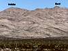
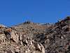
The El Dorado Mountains are located about 30 miles southeast of the Las Vegas Valley. It is located between HWY 95 and the Colorado River between the Boulder City and Searchlight, NV. Sometimes this mountain range is referred to as Ireteba Peaks Wilderness. Comprising nearly 33,000 acres, this wilderness area was designated by Congress in 2002. Great views can be enjoyed of the Colorado River, Lake Mohave, and many peaks of Southern Nevada and Northwest Arizona.The terrain is much diversified. The southwest is rugged. Gentle hills dominate the northwest side formed by the erosion and flow of basalt. The east side has volcanic cliffs cut by deep canyons. Volcanic boulders and vegetation covers the landscape. Elevations range from about 3,800 feet to many peaks hovering around 5,000 feet. The highest being Ireteba Peak at 5,060 feet. Some of the wildlife in the area includes Desert Bighorn sheep and the desert tortoise. The Colorado River and Springs in the area provide water for the wildlife.
 |  |  |  |  |
Wildlife Bighorn sheep and desert tortoise are fairly common. Springs and the Colorado River provide water for wildlife. Archeological and mining artifacts can be found in the area. The name "El Dorado" refers to the legendary city of gold, and gold mining activity still occurs near the wilderness area boundary.
The name "El Dorado" refers to the legendary city of gold, and gold mining that still occurs near the area.
Getting There
From Las Vegas drive South on HWY 93/95 towards Boulder City. Just passed the Railroad Pass turn south on HWY 95 towards Searchlight. Drive 28.2 miles and turn left (East) onto a dirt road just past mile marker 28. Go on this dirt road for 2 miles. Turn left and drive for 0.7 miles and then turn right on another dirt road. Then turn right onto another dirt road for 2.6 miles and park just before the road curves to the right (South). There will be a wildlife guzzler a little before the parking spot on the right. The coordinates for the parking spot are 35º 35.067 N and 114º 50.313 W. Elevation is approximately 3,880 feet. A 4WD is not needed to get here, but a high clearance vehicle is.Alternative route if coming from the South
Driving through Searchlight at the intersection of HWY 95 and HWY 164, drive North on HWY 95 for about 7.6 miles. The dirt road is on your right. Turn right (East). Go on this dirt road for 2 miles. Turn left and drive for 0.7 miles and then turn right on another dirt road. Then turn right onto another dirt road for 2.6 miles and park just before the road curves to the right (South).
Peaks in the Range
 Ireteba Peak
Ireteba Peak Elevation 5,060 feet
 Bard Peak
Bard Peak Elevation 4,969 feet
There are many other unnamed peaks in this range. Many are near or just above 5,000 feet.
Red Tape - Camping
There are no permits needed. Camping is permitted anywhere within 100 feet of a designated road as long is it is not within 1/4 mile of a water source.For more information contact:
Management Agency:
Bureau of Land Management
Las Vegas Field Office
4701 North Torrey Pines Drive
Las Vegas, Nevada 89130
(702) 515-5000