
-
 12409 Hits
-
 94.02% Score
-
 45 Votes
|
|
Mountain/Rock |
|---|---|
|
|
38.20369°N / 111.19364°W |
|
|
Scrambling |
|
|
Spring, Fall, Winter |
|
|
6945 ft / 2117 m |
|
|
Eph Hanks Tower and Point 6945
Overview
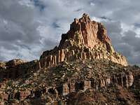
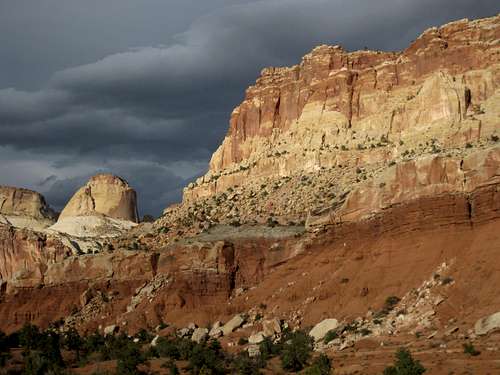
Viewed from the picnic area at the entrance to Capitol Gorge, Eph Hanks Tower certainly lives up to its name. It looks like a classic desert pinnacle with sheer cliffs guarding the summit on all sides and with a summit block that itself looks formidable.
Don’t be fooled. First, the name is misleading. The “tower” is actually the north end of a long ridge just west of Capitol Reef, a particularly spectacular section of the 100-mile-long Waterpocket Fold. The summit block, seen from other angles, is obviously easy to walk up (once one is atop the ridge, of course, and getting up there is no stroll). And the summit block is not even the highest point on the ridge; there are at least three other notable outcrops that are higher, and parts of the ridge itself are higher. The highpoint of the ridge is actually 6945' although the "tower" is about 6540'.
But that does not make Eph Hanks Tower easy to climb. Far from it-- although there is a way other than climbing directly to the summit from the aforementioned picnic area, a climb that would be technical, it is not simple at all. Getting up there will require route-finding and scrambling skills, scrambling that almost certainly will fall into the Class 4/“easy” Class 5 range. It did for me, anyway.
You are virtually assured of solitude up here.
This page will tell you how to climb the ridge and reach both its highpoint and that of Eph Hanks Tower. I will not attempt to detail my exact route, though I will provide some general details. I also do not claim that my route up is the only way or the best way. What I want to do is provide an idea of what you are in for if you want to climb this peak. If you don’t like Class 4 or have never soloed up to, say, 5.4, you probably should not try climbing this peak.
 Point 6945
Route Information

I'd love to be able to tell you something specific about route length, but something went a little crazy with my GPS device, and it returned a track of about 58 miles, which is a little inaccurate. So I'll go with this: since I drove almost two miles from the view of Eph Hanks Tower to where I parked, and since that drive paralleled the ridge housing this peak, you should expect a one-way distance of approximately two miles.
Elevation gain is about 1100' to Point 6945, less if you only are interested in the summit of Eph Hanks Tower.
As stated in the Overview, avoid this climb if you are not comfortable with Class 4-5.2 terrain, and be prepared to spend some time finding the right way up and possibly not to find it at all.
This is a mountain bereft of trails or other signs of people. Please make every effort to keep it that way. When I reached the summit plateau, I did make a cairn so I could find the correct route on the way back, but I dismantled the cairn and scattered the rocks upon my return to it.
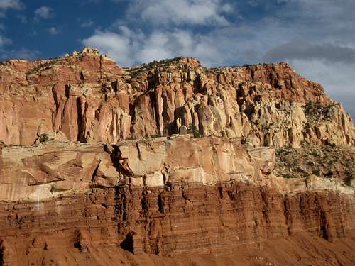
The mountain is guarded by several cliff bands, including one along the base, which is why I had to drive almost two miles before finding a suitable approach to a peak right above me. Two gullies represented the first decent breaks in the lower cliff band, and I climbed one of them to begin an ascending traverse to the north.
It gets vague here. Hopefully, you scouted things from the road and have an idea of where you are. Basically, I tried to stay on the easiest ground possible while staying above the cliff bands and avoiding giving back gained elevation. There was plenty of Class 3 terrain and loose rock. Eventually, I had to climb a Class 4 pitch up something that was between a crack and a chimney (Class 4 overall, but it had one Class 5 spot) to get through the uppermost band of cliffs and reach the summit plateau.
Point 6945 was almost directly ahead of me. The summit block of Eph Hanks Tower, which looks somewhat daunting from some positions below, was a downhill walk of no more than a mile and an easy scramble.
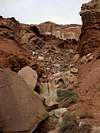
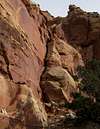
The thumb-size photos below show and describe some key spots on the route I took, and there is a route diagram, too.
 |
 |
 |
 |
 |
 |
Eph Hanks
Ephraim Hanks was the namesake for this peak. The following biographical information is copied from the Wikipedia entry for Ephraim Hanks:
"Ephraim Knowlton Hanks (b. 21 March 1826 - d. 9 June 1896) was a prominent member of the 19th-Century Latter Day Saint movement, a Mormon pioneer and a well known leader in the early settlement of Utah.
Hanks was born in Madison Lake, Ohio, the son of Benjamin Hanks and Martha Knowlton. Hanks left home at age 16, working for a time on the Erie Canal and then serving in the United States Navy. Returning home to Ohio, he learned his brother Sidney had joined The Church of Jesus Christ of Latter Day Saints. Hanks soon accepted the young church's teachings and became a member in 1845.
Hanks left Nauvoo, Illinois with the LDS followers of Brigham Young on the trek west to the Rocky Mountains. However, he left the main body of emigrants to join Company B of the Mormon Battalion, United States Army, and marched with them to San Diego as a private. He and other Battalion members marched from the Midwest, south through Arizona, and were released from service in California. Battalion members rejoined the Mormon emigrants from the west, traveling from California to the Salt Lake Valley.
In 1856, Hanks played a role in the rescue of the Martin handcart company, although he wasn't present during the famous Sweetwater crossing.[1] Hanks also led a militia company in scouting expeditions during the Utah War in 1857 and 1858.
As a member of The Church of Jesus Christ of Latter-day Saints, Hanks practiced plural marriage, having four wives and 26 children. His wives were Harriet Amelia Decker (m. 22 September 1848), Jane Maria Capener (m. 27 March 1856), Thisbe Quilley Read (m. 5 April 1862). A fourth wife, Hannah Hardy, never lived with Hanks and the union was dissolved in 1856.
Hanks was ordained a Patriarch in The Church of Jesus Christ of Latter-day Saints and was known for his obedience to church leaders. President Brigham Young said that Hanks ... was a man always ready to lay down his life for the authorities of the Church as well as for the cause of Zion and her people. (Richard K. Hanks, pp. 2627.)
Hanks was a U.S. mail carrier from 1851 to 1853 and later acted as a station master for the Pony Express, facilitating mail service on the Mormon Trail to Salt Lake through Utah's Emigration Canyon. "Hanks' Station" was located on the Mormon Trail in Mountain Dell, a valley between the Big Mountain and Little Mountain, also known as Big Canyon, named for the creek that still runs through that area. The historic station has been removed, but its site sits on the edge of what is now Little Dell Reservoir.
Hanks died at his home at Floral Ranch, Wayne County, Utah and buried in the Caineville Cemetery."
Note: Eph Hanks was not the namesake for nearby Hanksville. Instead, that was his second cousin, Ebenezer Hanks.
Technical Climbing in Capitol Reef National Park
I checked on Rockclimbing.com and also Googled for routes directly up Eph Hanks Tower but found nothing. I did find some books that might have information (see below under the guidelines and restrictions), but it was impossible to tell from the search returns themselves.
If you do want to climb here, whether it’s to establish a new route (it’s my understanding that Capitol Reef has not seen anywhere close to the route development that some of the other Utah parks have), you need to know the following guidelines and restrictions, copied from the NPS site for Capitol Reef, in place at this park:
ROCK TYPE
The rock at Capitol Reef is comprised predominately of sandstone. It varies in hardness from the soft crumbly Entrada to the relatively hard Wingate. The Wingate cliff walls are the most popular for climbing, as natural fracturing has created many climbable crack systems. In addition, the hardness of the Wingate lends itself more readily to the successful use of chocks, nuts, and camming devices; however it can flake off easily and be very unpredictable. Climbing in canyon country is not something to be taken lightly.
ROUTE DESCRIPTIONS
Two published guides cover climbs at Capitol Reef. They are Desert Rock by Eric Bjornstad from Chockstone Press, Inc., 1996 and Rock Climbing Utah by Stewart M. Green from Falcon Publishing, 1998. Both are available for sale at the visitor center bookstore. If you climb a new route and wish to leave a route description contact a ranger at the visitor center.
PERMITS
Permits are not required for climbing. However, if you plan to camp overnight on a climb, you are required to obtain a free backcountry use permit, available at the visitor center.
RESTRICTIONS AND CONCERNS
Capitol Reef National Park is a clean climbing area. Minimum impact techniques that don't destroy the rock or leave a visual trail are encouraged. The use of white chalk is prohibited. Climbers using chalk must use chalk which closely matches the color of the surrounding rock. The use of power drills is also prohibited. Bolts may only be used to replace existing unsafe bolts. Where it is necessary to leave or replace existing webbing, the webbing should closely match the color of the surrounding rock. Ropes may not be left in place unattended for more than 24 hours, and these ropes must be out of reach from the ground or other points accessible without technical climbing.
CLOSED AREAS
Due to the abundance of prehistoric rock writings, the section of the rock wall north of Utah Hwy 24 between the Fruita Schoolhouse (Mile 80.6) and the east end of the Kreuger Orchard (Mile 81.4) is closed to climbing. In other areas, climbing is not permitted above or within 100 feet of rock art panels or prehistoric structures. Other areas closed to climbing are: Hickman Natural Bridge and all other arches and bridges, Temple of the Moon, Temple of the Sun, and Chimney Rock.
SAFETY
Climbing during the summer is very hot as temperatures frequently reach the upper 90's to near 100 degrees. Carry plenty of water. Afternoon thunderstorms are common in July and August. Sandstone is weak when wet, so avoid climbing in damp areas or right after a rain. Please climb safely! Many falls have been taken on relatively easy routes because experienced climbers became careless. Please report all accidents or injuries at the visitor center.
Getting There
From the visitor center, drive south on Scenic Drive for 8 miles to a picnic area at the junction of Pleasant Creek Road and the road into Capitol Gorge. To follow the route I describe above or one similar to it, turn right onto Pleasant Creek Road and drive about 1.6 mi. Do not block the narrow dirt road when you park.
Red Tape
There is not a fee to enter the park, but to drive on the Scenic Drive that accesses this peak, drivers are required to stop at a self-pay station and remit a fee of $5 (good for seven days); the fee for pedestrians and bicyclists is $3.
As much as possible, avoid stepping on the biological crust out here; it is alive and is critical to the desert ecology, and it is fragile. If the soil looks lumpy, dark, or crusty, avoid it. Better yet, try to stay on exposed rock and in sandy washes as much as you can. There is not too much of it on this peak except on the summit plateau, where there is a lot of it.
More about the crust...
Camping
Fruita Campground, at the start of Scenic Drive, is a nice play to stay because of all the grass and cottonwoods there. Flush toilets and running water are available. Sites cannot be reserved. The nightly fee in 2009 was $10.
External Links
The following sites have good information about the park:
NPS Capitol Reef site
Capitol.reef.national-park.com
hgrapid - Dec 22, 2010 12:15 am - Hasn't voted
In ChinaBob, You placed the coordinates in China: 38.20369°N / 111.19364°E -111.19364. I am sure just a minor oversight nobody bothered to check.
Bob Sihler - Dec 22, 2010 4:29 am - Hasn't voted
Re: In ChinaThanks. Yeah, I guess I was just a little sloppy when I did that!