
-
 19465 Hits
-
 94.2% Score
-
 46 Votes
|
|
Mountain/Rock |
|---|---|
|
|
38.30655°N / 111.26581°W |
|
|
Hiking, Trad Climbing, Scrambling |
|
|
Spring, Summer, Fall, Winter |
|
|
7000 ft / 2134 m |
|
|

Overview
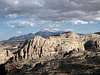
Conventional wisdom probably holds that the best hike in Capitol Reef National Park is Upper Muley Twist Canyon and that the best backcountry route is Halls Creek Narrows, but the Navajo Knobs, named, I think, for the Navajo sandstone found on them, are also an excellent destination, though not as remote as the other two. You won’t find the Navajo Knobs marked on topographic maps, but some hiking maps and guides for the park do show/mention the Navajo Knobs, where 360-degree views of the park await.
This source says "The knobs are a pair of small hills that sit atop a jutting section of the Waterpocket Fold, between the Castle and the Mummy Cliff," but I do not know where that source, which is a travel guide, gets that information. There are really at least five peaks in the vicinity that could all be considered as part of the Navajo Knobs complex because of their proximity, form, and composition.
A trail leads to the small summit of one of the knobs, but skilled scramblers will want to climb some of the other knobs, including the highest of them, which is separated from the trail-accessible one and is a Class 4 affair (at least). The highest knob is also larger and more spectacular, and the views from it are much better.
The Navajo Knobs are not a secret, but because a nine-mile hike (round trip) is involved, you are unlikely to find yourself sharing the destination with a lot of other people.
An outing to the Navajo Knobs is therefore nice because there are good chances for solitude, the entire route is scenic, and the area has something for people of all ability levels and interests. The destination thus lends itself to mixed-company forays from which everyone walks away happy.

Getting There
Two miles east of the park's visitor center, just before a bridged crossing of the Fremont River, turn into a large parkign area signed for Hickman Natural Bridge.
Route Information

The trail route is 4.5 miles (one-way distance) and climbs about 1600'; the Park Service rates the hike as strenuous, but the typical SP member is probably going to think it's moderate, maybe even easy (I put it between moderate and easy). If you climb High Knob instead, distance and elevation gain are going to be about the same. If you climb Trail Knob and High Knob, add around half a mile and 300-400' to the route.
Begin hiking on the trail for Hickman Bridge, Rim Overlook, and Navajo Knobs. After a short distance, the trail splits, with the right fork continuing to Rim Overlook and Navajo Knobs. Here, trail traffic thins dramatically since a large majority of hikers here are going to Hickman Bridge. Hickman Bridge is a nice destination and worth seeing, but it is just a dead end if the Navajo Knobs are your goal.
The trail now alternates between following washes and crossing open expanses of slickrock, and there are always great views of sandstone cliffs, domes, and monoliths, many of which have no official names. Cairns mark the preferred route and help one avoid stepping on the biological crust out here; it is alive and is critical to the desert ecology, and it is fragile. If the soil looks lumpy, dark, or crusty, avoid it. Better yet, try to stay on exposed rock and in sandy washes as much as you can. (More about the crust...)
2.25 miles from the trailhead, the trail reaches Rim Overlook, a good vantage point for viewing the visitor center area and Capitol Reef itself. What crowds might still be left will almost totally disperse now, and you are likely to have the rest of the route to yourself or share it with only a few other people. This is also the halfway point of the route.
From here, the trail follows long, gentle ramps to skirt the rims of two canyons. Seldom-seen views of the castle, one of the park's most interesting formations, add to the enjoyment of this part of the hike.
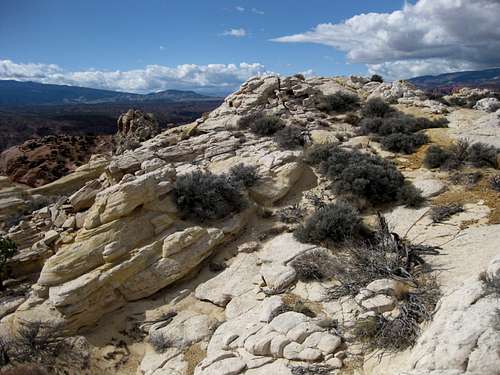
About a mile from the end of the trail, you begin to see and pass a series of sandstone domes and outcrops. I do not know exactly which formations are considered to be among the Navajo Knobs and which are not, but there is no question that here the character of the terrain changes from cliffs and canyons to these domes and outcrops.

"Trail Knob"
For purposes of this page, this is the name for the peak the trail climbs. It is the westernmost of the knobs and thus has some pretty precipitous drops on some sides. At its end, the trail climbs to a little saddle just east of the summit and then ascends some loose rock and dirt a short way to the top of the peak. A little scrambling is required to get on the actual highpoint, but everything else is a walk, though some hikers might want to use hands for a little extra security.
From this peak, it is easy, and advisable, to study the next peak to the east, which is the highest of the Navajo Knobs and the focus of the next section.
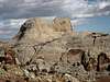
 Summits of Trail Knob and High Knob
"High Knob"

For purposes of this page, this is my name for the highest of the Navajo Knobs. The route I found up this peak followed a series of gullies and cracks. It was a Class 4 route, though some individual moves fell, in my opinion, into the low Class 5 category. In some places, there is enough exposure to make you wonder if it's wise to be climbing this unroped. However, anyone experienced on Class 4 and low Class 5 terrain without roping up should not have any real trouble here. I do not recommend this for anyone who has yet to venture beyond Class 3; please move to the harder stuff on better rock, for here, the sandstone can make purchase difficult and holds easily breakable.
This is not some massive peak that could confound the hardiest mountaineer, so I will not attempt to explain the route in painstaking detail, as anyone with a little patience and scrambling experience as noted above will not have too hard a time finding the way (or a way) up. For an overview of part of the route, please see the picture at the end of this section.
To reach this peak, the best thing to do seems to be to hike all the way to the saddle just east of Trail Peak and then traverse east. I found the going better on the left (north) side, but I am pretty certain the other side would work, too. After the traverse, I located a brushy gully I had spotted from Trail Peak and began the climbing and searching. The route was not in a straight line, and parts were on the north, west, and south sides of the peak. The final part of the climb was up a crack on the north side, and from there it was a short walk to the summit, which showed no signs of recent visitation and did not even have a cairn (and still did not when I left).
I did search for alternate ways back down but kept cliffing out.
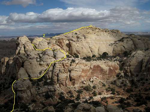 Route Diagram
Other Knobs and Routes
There are five formations (arguably, an outlier section on High Peak is a separate one, making six) that could be considered to be part of the Navajo Knobs. Based on what I could see from the trail, two of the other three would be technical climbs and the third, the smallest of them, has what looks like a Class 4 route on it.
Should you decide to make a technical ascent on any of the knobs, you do have to know the following:
• You may not put in any new bolts and may only replace existing unsafe ones.
• Power drills are prohibited.
• White chalk is prohibited.
The Knobs-- Gallery
Click on any to read captions and view in a larger format.
 |
 |
 |
 |
 |
 |
Views from the Knobs
Click on any to read captions and view in a larger format.
 |
 |
 |
 |
 |
 |
Views from the Trail
The views from the trail are almost as good as they are from the summits. In fact, they're arguably better; while you don't get the 360-degree panoramas, the cliffs and monoliths soar above you. The views are in sequence from trailhead to trail's end; click on any to read captions and view in a larger format.
 |
 |
 |
 |
 |
 |
 |
 |
 |
Red Tape
There is not a fee to enter the park.
Camping
Fruita Campground, at the start of Scenic Drive, is a nice play to stay because of all the grass and cottonwoods there. Flush toilets and running water are available. Sites cannot be reserved. The nightly fee in 2009 was $10.
External Links
The following sites have good information about the park:
NPS Capitol Reef site
Capitol.reef.national-park.com