
|
|
Mountain/Rock |
|---|---|
|
|
34.22831°N / 117.57255°W |
|
|
San Bernardino |
|
|
Hiking |
|
|
Summer |
|
|
8662 ft / 2640 m |
|
|
Overview
Etiwanda Peak is a relatively infrequently climbed summit in the Cucamonga Wilderness.
It was named by two Sierra Club members in the 1930's for the town it overlooks.
The peak lies within San Bernardino County and is part of the San Bernardino National Forest but it is the easternmost peak of prominence in the San Gabriel Mountains. It is somewhat overshadowed by Cucamonga Peak, the larger summit to the west.
There are three routes up the mountain with the easiest and shortest climbing out of Joe Elliot Campground. The Middle Fork of Lytle Creek is another option, and the route up Icehouse Canyon is quite a long distance trek.
The road into Joe Elliot Campground is rough, often closed, and high clearance and/or four wheel drive is recommended for more than one section of the roadway. Check with the Lytle Creek Ranger Station before attempting the drive.
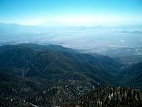
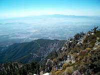
The summit block of Etiwanda Peak is small. There is room for two people at best; some easy Class II scrambling is required to get to the top. The view is 360' unlike Cucamonga, but the western vistas are obscured by the shoulder of the aforementioned peak. Views to the south, east and north are spectacular and the wraparound is an all around better view than that of the top of Cucamonga.
Getting There
Joe Elliot Trailhead 9 miles 2750' elevation gain
Take Interstate 15 north of Rancho Cucamonga to Sierra Avenue, exit and turn north towards the mountains, drive for 1.5 miles. Turn left onto Forest Road 1N34, it is signed for San Sevaine Flats and Joe Elliot Campground. Stay straight for 7.5 miles and then keep straight(left) again at a very obvious fork. At 11.5 miles in turn right into the campground and the site of the once glorious Joe Elliot Tree. Follow the blocked road up until it turns into a trail.
The road into Joe Elliot Campground is rough, often closed, and high clearance and/or four wheel drive is recommended for more than one section of the roadway. Check with the Lytle Creek Ranger Station before attempting the drive.
This area was burned in the Old Fire of 2003. Check with the ranger station before attempting, and bring a good map and/or GPS. The trail is not maintained and good route finding skills are a positive. A short but steep mountaineer's route ambles to the summit from the western side after wrapping all the way around the base.
Middle Fork Lytle Creek 16 miles 4700' elevation gain
Take Interstate 15 north of Rancho Cucamonga to Sierra Avenue. Exit and turn left towards the mountains. Follow Sierra Avenue as it becomes Lytle Creek Road. Continue to the tiny burg of Scotland and turn left onto Middle Fork Road. Follow it to its completion.
The Middle Fork of Lytle Creek used to be one of the most popular areas in the San Bernardinos. It's easy access and beauty made it incredibly popular. The Old Fire ripped through here in 2003, so it is doubtful it retained all of its former glory, though there are some spectacular waterfalls along the trail. The trail climbs to Icehouse Saddle. Follow the trail to Cucamonga Peak and continue past the branch for about a mile to the faint mountaineer's route up Etiwanda.
Icehouse Canyon Trailhead 17 miles 3800' elevation gain
From Highway 60, Interstate 10, or 210, take the Mountain Avenue exit in Chino, Montclair, or Upland, respectively. Head north towards the mountains and follow the road to its merger with Euclid. Veer left as the road curves around. Turn right onto Mount Baldy Road. Follow it for 6.5 miles and turn right into the Icehouse Canyon parking area.
Follow the trail to Icehouse Saddle. The fork for the Chapman Trail is a less steep option to the saddle but it adds 2 miles(one way) distance to an already long hike. At the saddle, there are several trail options. The south winding trail to Cucamonga Peak is the one to follow. Be certain about the trail. Continue 1 mile past the branch for Cucamonga and take the faint mountaineer's route to the top of Etiwanda.
Red Tape
A wilderness permit is required for all day hiking and camping in the Cucamonga Wilderness. Icehouse Canyon permits need to be picked up at the Mount Baldy Ranger Station in Baldy Village. Middle Fork and Joe Elliot permits need to be picked up at the Lytle Creek Ranger Station. Permits can be mailed in advance, so it is best to plan ahead.
It is a good idea to call ahead on this hike anyway due to road access and fire damage.
An Adventure Pass is needed for parking in the National Forest. Passes are $5 daily or $30 for an annual pass.
Adventure Pass
Mt. Baldy Visitor Center
Mt. Baldy Road
Mt. Baldy, CA 91759
(909) 982-2829
Daily 8:00 am - 4:30 pm
Cajon Ranger Station
1209 Lytle Creek Road
Lytle Creek, CA 92358
(909) 382-2850 (voice)
(909) 887-5783 (TTY)
Camping
Commanche is a primitive campground along the Middle Fork of Lytle Creek 1.5 miles and 1400' feet below Icehouse Saddle. Third Stream Crossing and Stonehouse are even lower and farther away from the saddle.
Kelly Camp is nearly a mile off the main trail at Icehouse Saddle on the Ontario Peak Trail.
Cedar Glen is three quarters of a mile up the Chapman Trail from the lower intersection.
Joe Elliot Campground is right off 1N34.
External Links
Best Hikes with Dogs Southern California by Allen Riedel
Cucamonga Wilderness
United States Forest Service