
-
 15948 Hits
-
 90.13% Score
-
 31 Votes
|
|
Mountain/Rock |
|---|---|
|
|
34.39000°N / 117.9093°W |
|
|
Los Angeles |
|
|
Hiking |
|
|
Spring, Summer, Fall, Winter |
|
|
7983 ft / 2433 m |
|
|
Overview: Namesake of a Prominent Ridge
The very name of this peak bespeaks great hiking. The peak takes its name from the beautiful miles-long ridge on which it is located. This prominent ridge is separated from the main body of the San Gabriel range by a desert bound drainage, Little Rock Creek.Pleasant View Ridge rises from the Mojave desert starting near Juniper Hills and winds southeasterly until reaching its end at 8,214’ Mt. Williamson. Juniper, Pinyon, and Jeffrey Pine dot the ridge’s higher slopes. Three miles along the ridge northwest of Mt. Williamson, there is a distinct gap on the crest between Will Thrall Peak and Pallett Mountain known as Burkhart Saddle (6,959’).
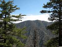 Pleasant View Ridge seen from Winston Ridge 7.07
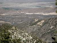 View north towards Mojave Desert from Pleasant View Ridge
  View south along Pleasant View Ridge near Will Thrall Pk
A final attraction of this peak is that, on the whole, it is not as heavily visited as other areas of the San Gabriel high country such as the Mt. Waterman area.
There are four routes to this peak.
Route 1: From Buckhorn Campground
Take the Burkhart Trail from Buckhorn Campground to the junction with the Rattlesnake Trail just after you cross Little Rock Creek. The continuation of the Burkhart Trail heading north is to the left. Take it 3 miles to Burkhart Saddle and then go left (west) up the use trail on the ridge. The use trail passes below Will Thrall Peak. Continue a little over a mile from the saddle to the summit of Pleasant View Ridge. There is an elevation marker on the summit.
 Summit of Will Thrall Peak between Burkhart Saddle and summit of Pleasant View Ridge
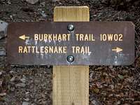 Trail sign. As of present, trail to right is off- limits
Route 2: From Near SR2’s Mile Marker 62.50
Drive to a parking area on the south side of SR2, about 2.4 miles east of the Snowcrest ski area and near mile marker 62.50. A trail at the east end of the parking area ascends Mt. Williamson’s southwest ridge. Climb to Willamson’s summit along the trail. At the summit, leave the trail and hike northwest along the top of Pleasant View Ridge (lots of ups and downs) 3 miles to Burkhart Saddle. Proceed as in Route 1 to the summit of Pleasant View Ridge.
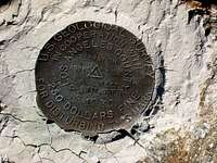 Elevation Marker on summit of Pleasant View Ridge.
Route 3: From Islip Saddle
Start out as in Route 2 except continue driving east on SR2 past mile marker 62.50, about 1.6 miles further to Islip Saddle. From the parking area take the trail that leads northwest up the ridge. After almost 2 miles of climbing, you reach the ridgetop and the intersection with the trail to Mt. Williamson described in Route 2. Proceed as in Route 2 to the summit of Pleasant View Ridge.
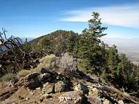 Pleasant View Ridge summit seen from Will Thrall Peak, 10.20.07
Route 4: From Devil’s Punchbowl
This route starts from the desert side. From Devil’s Punchbowl County Park, take the Burkhart Trail from its northern terminus up the steep slopes of Cruthers Creek to Burkhart Saddle. It is about 7 miles from the start to the saddle. Proceed as in the above routes to the summit of Pleasant View Ridge.
 NE Ridge of Pleasant View Ridge peak dropping toward desert, 10.20.07
Getting There
For Route 1From the 210 Freeway, exit at Angeles Crest Hwy (SR 2) and go north. At 9.5 miles, you will come to the Clear Creek Information Station and the junction with Angeles Forest Highway. Continue straight and in 4.5 more miles you will come to the junction with the Mt. Wilson Road at the Red Box Ranger Station and trailhead. From here, continue on SR2 for 20 more miles to Buckhorn Campground. The campground entrance is about ½ mile past the Mt. Waterman Ski Area. Be looking for the entrance on your left as it can be easy to miss. Proceed into the campground and follow the signs to the day use parking area, about .8 miles from the entrance. The trailhead for the southern end of the Burkhart Trail is next to the parking area.
For Route 2
Drive as in Route 1 but continue past Buckhorn Campground to a parking area on the south side of SR2, about 2.4 miles east of the Snowcrest ski area and near mile marker 62.50. A trail at the east end of the parking area ascends Mt. Williamson’s southwest ridge.
 Looking south into Bear Creek from Angeles Crest Hwy near mile marker 62.50
For Route 3
Drive as in Route 1, but go about 6 miles past (east) Buckhorn Campground to Islip Saddle. From here, a trail ascends to the south ridge of Mt. Williamson.
For Route 4
Drive to the town of Pearblossom on Highway 138, then south and southeast on County Road N6 about 8 miles to Devils Punchbowl County Park. For more specific driving directions see the Sierra Club’s Hundred Peaks Section’s “Driving Route 2” for Pleasant View Ridge
Red Tape
You will need an Adventure Pass or Golden Eagle Pass to park your vehicle at the parking areas for Routes 1, 2 and 3. Besides some Forest Service locations, they are sold at most major sporting goods stores in southern California ($5 per day and $30 for an annual pass).For Route 4, the Burkhart Trail from Devil’s Punchbowl, you can park gratis at the nature center parking lot. However, the lot is only accessible between sunrise and sunset.
No permits are required for hiking the routes described here.
Camping
There are 35 developed campsites at Buckhorn Campground where the trailhead for the southern end of the Burkhart Trail is located. Currently, the sites are $12 per night. The campground is open April 1 through November 30.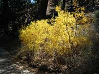 Fall 2007 colors in Buckhorn Campground
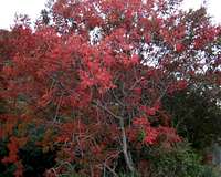 Fall 2007 colors along Angeles Crest Hwy
When to Climb/Mountain Conditions
This peak and the ridge on which it is located can be climbed year-round. During the winter, with snow cover, bring appropriate gear. Check forecast information in local newspapers or internet weather services during the winter months. Check with Cal Trans (see link below) on road conditions and closures during the winter. Always carry chains for your vehicle during the winter.Other Information
USGS Topos Juniper Hills 7.5 Waterman Mountain 7.5Valyermo 7.5
Harrison’s Angeles High Country Trail Map
External Links
Devils Punchbowl County ParkAngeles National Forest
Adventure Pass information
California Dept. of Transportation