A total lack of planning comes together
On July 7th I set a new personal record for distance hiked within a 24-hour day: about forty miles (with about 7000 feet of elevation gain). It was an accident. Here's how it happened.
Along with a few other SPers, I'd been planning a Devil's Path {Catskills} traverse for months. Puma Concolor and I eventually settled on the date of July 14th, even though that meant WalksWithBlackFlies and MudRat would have to miss it because they'd be doing their
ADK Ultramarathon during that time. Then Puma's work schedule went all moebius-shaped and I found myself with a gap in my calendar.
In order to prepare / test myself for
Sufferfest 2007, I needed to do a big hike in early July. Something with lots of distance and lots of elevation gain, preferably a loop so I could do it without any logistical support, and ideally something within an easy drive of Boston. As of July 1st, I had in mind some kind of loop involving most or all the northern Presidentials and the Great Gulf trail. By way of preparation, I went for an eight-mile run on the morning of the Fourth. Then on Thursday the fifth, about the time I was failing to spot the fact that I had written $h->{MtgMinutes} when I meant $h->{MtngMinutes}, I had the kind of dubious inspiration worthy of the original Devil's Path plan: why not do
the loop: the
Pemigewasset Loop? At only two hours from home, I could even sleep in my own bed if I woke up really early in the morning.
Let me emphasize that I knew from the start that this was a rather half-baked scheme along the lines of
climbing the Tripyramid North Slide in December or
attempting a Great Range Traverse with no preparation. That was the point, after all: the Devil's Path traverse had been planned as a folly all along. So once more for the record: kids, talk to an adult with functioning brain cells before you try something this stupid.
On Friday night I packed some camping gear (for after the hike) in one bag, and my hiking gear in another. My plan was to go fast and light. I left behind everything nonessential, taking only my walking stick, water bottles (two empty liter bottles, two half-liter bottles of Gatorade, no filter), headlamp and flashlight (with spare batteries), rain pants, raincoat, hat, gloves, food, compass, map, toilet paper, knife, and lighter. I also brought my point-and-shoot camera, which I planned to keep inside my backpack so I wouldn't be tempted to slow down for photos (also because last time I wore it on its strap while jogging, the repeated bumping left quite a bruise). I left a fleece out to wear on the drive up, but I planned to leave it in the car.
Long Day's Journey
![View from Bondcliff]() View from Bondcliff
View from BondcliffOn Saturday I was up early and out the door shortly after 6 AM. I pulled into Lincoln Woods at 8:15 and promptly got moving. It was chilly so I kept the fleece on, even though I knew I'd be shedding it a few minutes later. Carrying the fleece would turn out to be the smartest thing I did all day - actually it was one of very few intelligent decisions I made during this entire adventure.
The Lincoln Woods trail is an old timber railway - wide and flat. My plan was to run for a mile or two, walk a bit, run again, and so forth. I started my stopwatch, planning to slow down after ten or fifteen minutes. It wasn't until I reached the Black Pond trail that I realized my watch had stopped: over three miles in under nine minutes? Not unless I'd died and been reincarnated as a caribou. Of course the real time was more like half an hour - a fairly decent running pace with a pack on my back and a walking stick in my hand. This faster-than-planned start would have me making far-too-optimistic projections all day long.
Readers familiar with the Pemi Loop will have realized at this point that I was taking the loop counter-clockwise. I'm not quite sure why I chose that direction. Some prefer this way precisely because they can cover the five flat miles of the Wilderness trail at a jogging pace while still fresh, rather than stumble over railroad ties in the dark at the end of the day; In retrospect I think I would have preferred to go clockwise.
On the Bondcliff trail I was mostly walking, with some dog-trotting on the smoother sections. I reached the top of Bondcliff at 11:15, a 3mph pace overall. Not bad for a trail with 3000 ft of elevation gain. I started thinking about what kind of trip report I'd write. "Pemi loop in 16 hours - including roundtrip drive to Boston!" Catchy title?
By the way, the pace and distance calculations in this report were all calculated afterward. During the hike, I tried not to look at my map, but I had a rough idea of distances from my previous hikes in the area. My plan was simply to Press On Regardless, and not make any decisions based on my pace at least for the first half of the hike. This didn't stop me from occupying my mind with making estimates and projections, as just mentioned. Since my memory of the distances and elevations was very vague, these estimates often proved laughably wrong. But when I'd come to a trail sign with the distance to the next objective marked, I'd set a time goal to reach it, and this helped me keep my pace up.
Speaking of Pressing On Regardless, when I last checked the weather forecast (Thursday night?) it called for a 40% chance of showers, with possible thunderstorms. I figured I would only be above treeline for a couple of miles at a time, so the odds of me being in a risky spot during lightning activity were acceptably low. Besides, this is New England! When has the forecast ever been right? As I passed treeline on Bondcliff the day was mostly sunny, cool for the season, with a breeze. The first gust caught me by surprise and knocked me sideways, but it was probably under thirty knots. A few people were standing right on the cliff edge with no cause for concern. The very top of Lafayette was barely touching the clouds, all the other peaks on my route were in the clear. Fine weather so far. I'd rather have a breeze and some clouds than suffer in high heat. Just like the last time I was on Bondcliff, the whole summit area was carpeted with
sandwort.
![View from Bond]() View from Bond
View from BondNext came the mostly above-treeline climb to the top of Bond. The wind grew steadier, and I used this to motivate myself to keep a fast pace for the sake of warmth. I reached the summit shortly after noon, just about what I'd hoped for when I left Bondcliff. Pausing only to take a photo or two, I pressed on towards Guyot and then South Twin. I'd decided from the outset that I wouldn't be visiting any of the "optional" peaks: West Bond, North Twin, or Galehead. (Some folks also detour to Zealand, and the real psychos bushwhack over to Owl's Head and back at some point along the way.) The Twinway from Guyot to South Twin is almost flat, densely wooded, and very quiet. I made good time and rather enjoyed myself.
![Guyot summit]() Guyot
Guyot
Without checking my map, I had the idea that Bond marks about a third of the overall distance (this was correct), and that South Twin marks the halfway point (that's about right in terms of elevation, but the halfway point for distance is closer to Garfield). So as I reached South Twin at 1:40, I was pretty happy: at that pace I'd theoretically be back at my car around 7PM, well before dark. (That's if you don't correct for all the running I did on the flat Wilderness trail, which I'd be hard-pressed to duplicate on the remaining trails. I knew this but figured I was still on pace for maybe 9PM, which would have made me quite proud.) I got a few funny looks when I mentioned my plans to other hikers I met on top of South Twin. It started when they asked what trailhead I'd come from. I had to explain where Lincoln Woods was. "That's a long day", they said. "It's only half over" was my reply. But their eyes really bugged out when I added, "last time I did the whole loop it took me four days." Well, the heavy pack including four days of food did slow me down...
![SOBO on South Twin]() South Twin
South Twin
The segment of trail between South Twin's summit and the Galehead Hut is one of the longest miles in the Whites. Eastbound, it's a tiring 1100-foot ascent. Westbound wasn't much better - a wearying descent in any circumstances, and passing showers had made the rocks a bit slippery. I remember setting a time goal based on a 2 m.p.h. pace, then revising it, then revising it again. I don't remember what time I reached the hut, but for the first time, I was tired, and disappointed at not having kept up a good pace. I refilled my water bottles at the hut and moved on, no longer trying to set a fast pace for the day but just trying not to get too far behind schedule. Slightly funny side note: in a case of history repeating itself (from
my first Presidential Traverse), I left my hiking stick leaning against the faucet when I walked out. Luckily I remembered it on the front porch of the hut (probably because I wanted something to lean on while descending the steps).
The Garfield Ridge trail is notorious for Pointless Ups and Downs (PUDs). As I left Galehead hut I imagined myself resting after the hike, composing a trip report, with a sentence something like: "I remembered hiking this segment with McRat, and how he grumbled about every little bump. I had no audience for my complaints, but I didn't let that stop me." So after a couple of bumps I was pleased to find myself still feeling OK as I started up a big slope that just had to be Garfield. I met two people coming the other direction who asked how far it was to Galehead hut. "About three miles," I promptly replied. They pointed out that this couldn't be right, since they could see the hut! Sure enough, there it was, plainly less than a mile away. I was still on the first big bump! In some confusion I checked my watch and found that I'd only left the hut half an hour before. It sure felt longer!
![Garfield summit]() Garfield
Garfield
By the time I really did reach Garfield it was nearly 5 PM. The wind had increased and the rain had become steady, with zero visibility, so I didn't linger on the summit. But in the few minutes I was exposed, I became chilled. My shirt and shorts (actually the tops of my zip-off pants) were soaked. I got back under treeline and kept moving, but it wasn't enough. I layered up, throwing on all the clothing I'd brought: pant legs, rain paints, fleece (glad I had it!), raincoat, hat, gloves. That helped, and as I kept moving I gradually warmed up.
I still had the west half of Garfield Ridge to contend with: more PUDs, more slippery rocks. I trudged on, not having much fun anymore. I checked my watch, made a realistic assessment of my pace (fading badly on the uphills), looked at the weather (steadily worsening), and decided that hiking the three miles or so above treeline on the top of Franconia Ridge would not be a good option in the dark. But it was far too early in the day to stop hiking; rather than backtrack to the Garfield Trail, I'd press on to the Skookumchuck trail. That trail would take me four miles out of my way to the north (the opposite direction from my car), but it would get me down (right around nightfall, at my current pace) and I planned to hitchhike once I reached the road. I consecrated this decision by drinking my last mouthful of Gatorade, which I'd been saving for the summit of Lafayette.
Somewhere along this ridge I was passed by a man wearing no rain gear, just a long-sleeved shirt and shorts. He was moving fast, practically running despite the wet rocks, and this was keeping him warm. Basically he was the embodiment of how I'd hoped I could do the whole loop - and plainly I didn't have nearly enough energy to do as he was doing. He was aiming for Lonesome Lake, but said that given the weather he might stop short because his car was parked "in the Notch" (he didn't say exactly where). We discussed possible bail-out options (backtrack to Garfield Trail, or proceed to Skookumchuck, or go over the summit of Lafayette to Greenleaf or Old Bridle Path), and he said "I think I'll just push through". I saw the soles of his shoes, and then he vanished in the mist. Push Through. Press On. Press On Regardless. It sounded good to my brain. It didn't sound very good to my legs. I kept walking.
Around 7:00 PM I realized that I'd chosen my bailout route without looking very closely at my map: the Skookumchuck trail tops out at 4700 feet, which is above treeline. I hauled myself up the steep alpine felsenmeer in zero visibility, fog mixed with rain, and some nasty wind. (The Mt Washington summit observatory recorded a high gust for the day of 72 mph. At a wild guess the strongest gusts on Franconia Ridge were probably something like 50 mph. Not much of a hazard in itself, but a pretty good test for outerwear.) Luckily I was fully warmed up by my ridge hike from Garfield, and my outer layers were zipped up tight and holding up well. But if speed is safety, I was in a precarious situation. The climb was draining my energy by the second. I'd take a step, pause to take two deep breaths, take another step. At one point I found myself in a sort of waist-high pit between boulders, and as I crouched momentarily out of the wind, a voice in my mind started whispering about how it wouldn't be so bad to curl up right here for the night. I shook my head and moved on, but the last vestige of indecision had been removed: it was time to bail out.
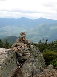
![Time to Bail]() Time to bail!
Time to bail!
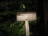
When I finally found the Skookumchuck trail, the sign said 0.8 miles to the summit of Lafayette. It might as well have been 18 miles, since only one direction held any interest for me: Down! It was 7:15 as I turned northward into the teeth of the wind and hoped I'd reach treeline quickly.
Into the Night
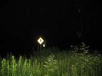
To my relief, treeline was not far away, and most of the rest of the trail was very gentle. In fact my main complaint about the Skookumchuck trail is that it's needlessly long: it runs parallel to the highway for over a mile while descending the last two hundred feet. I could hear and even see the lights of cars going by, only to be mystified at this seemingly endless trail. But eventually, at 10:30 PM, I stumbled out onto the highway. My adventure was over, a decent attempt at the Pemi Loop but no cigar, just a bit of hitchhiking left to get back to the car which had my tent, food, stove, and some extra Gatorade.
![Down at last!]() Down at last!
Down at last!
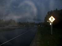
11 PM. Still attempting to hitchhike. Cars are going by every five minutes on average, but nobody's stopping. Oh well, the rain has stopped and walking along the road is easy. It's not even windy down here. The fireflies are beautiful.
Midnight: I'm inside Franconia Notch. Something large jumps into Profile Lake as I approach -- probably a moose but I can't see it. (Edit: upon sober reflection it was more likely a beaver splashing its tail.) I've switched to the bike trail since the highway is narrow with no real shoulder; I don't feel too safe walking on it.
1 AM: Back on the highway, hoping somebody will pick me up. No luck. I pass Lafayette Campsite; I check the buildings to see if a ranger might be awake, but I don't feel like waking anybody up just to ask for a ride. I notice for the first time that one of the buildings is a "lodge". I wonder if I should stop for the night, but then I see the No Vacancy sign. Back to the highway I go. It's strange to see highway signs up to a mile away when illuminated by headlights, and then not see them again until I get within a few yards of them.
2 AM: OK, this is ridiculous. My legs are really tired and I've got a blister under the ball of my right foot. Time to think about finding a quiet spot to lie down for a few hours. My flashlight is dying - my headlamp is still OK though, and I've got spare batteries. I decide to just use the headlamp for now. I'm still in the Notch, so besides the highway itself there's a drainage ditch (flooded) and then steep rocky slopes (no place to sleep). I pass a wider grassy spot and tell myself I'll stop at the next one. There is no next one.
3 AM: I've taken the North Lincoln exit onto route 3, hoping to find a motel or a campsite or just a spot to lie down that's not right next to the interstate, or maybe some friendlier drivers (I've found that locals on small roads are more likely to give a ride to a hiker). I do find some motels and campgrounds, but nobody's awake and they're all full anyway. Eventually I find a grassy spot off the road. This'll have to do.
![Bivy spot]() Bivy spot
Bivy spot
I get all my layers back on, plus a pair of wool socks I've had in my backpack. When removing my shoes I notice that both of my feet are bloody. I thought blisters only happened to other people. Guess I was wrong. While pulling the socks out of my pack I stumble upon a mylar "emergency bag" in there. This seems like a good time to put it to the test, so I unfold it carefully and crawl in slowly (I remember ripping my last one in half). I get as comfortable as possible and try to sleep. At first I'm too wired, but I take some deep breaths and start to relax. Now the problem is insects swarming around my face and crawling on my eyelids. I lower the visor on my hat, bury my face in my arms as much as possible, and try to ignore them. I'm only slightly successful until the rain starts up again and drives the insects away.
Twice during the night I wake up with the distinct impression that while asleep I've been hearing footsteps. Once I thought I felt something nudge my leg. Each time I spring up, ready to defend my food or my life against bears or highwaymen, but see nothing.
And day again!!?!
![On my feet again]() Morning
Morning5:25 AM: Dawn is breaking, or would be if not for the clouds, and a chorus of birds has decided that I should wake up now. I actually feel fairly refreshed. I'm not even very cold. I don't think the mylar bivy sack has made much of a difference, but it can't have done any harm. I have a breakfast of beef jerky and the last of my granola bars, then I pack the mylar sack and stand up. There, inches from my backpack, is a very distinct trail where a large animal has come through the waist-high weeds. About four feet from where I'd laid my head is a "nest" where something laid down for a nap. Maybe the trampled area had been there all night - I could easily have missed it in the dark. But it looked pretty fresh.
6 AM: still walking, still being ignored by passing cars.
7 AM: I've passed through the town of Lincoln and am now less than three miles from my car. I'd like to finish this entirely on foot; it'll be less than 24 hours. A nice round number and another goal to shoot for. But I also want to see if I'll ever get a ride or if I'll be ignored all the way back to the trailhead. I keep sticking my thumb out - it's kind of a game, or a sick joke, or something.
![A sight for sore eyes (and feet)!]() At last!
At last!7:15 AM: My new best friend Kier (hope I spelled that right) gives me a lift for the last mile or so. I'm marvelling at our speed and basking in the hot blast from the heater. Seconds later I'm finally back at my car. I take a photo to mark the time, change shoes, gulp some gatorade, and drive back to Boston while adrenaline is still keeping me awake. By the time I see the Boston skyline I'm having trouble keeping my eyes open, but I turn the radio up and I make it home in one piece. As I get out of the car in my driveway it's probably eighty degrees and rising. Once inside I turn on my air conditioner, collapse for about three hours, eat whatever's in the fridge (can't recall what it was), sleep a few more hours, whip up a meal of a thousand calories or so (softboiled eggs, buttered toast, ice cream for dessert), eat it, sleep a few more hours, and repeat until Monday morning.
Lessons learned, sort of
I learned a lot about how stupid I can be sometimes, and about my physical limits. Am I ready for Sufferfest? No, not really. Will I go for it anyway? I haven't decided yet.
Postscript
It has been suggested that my route constitutes a new loop and needs a name. Should anyone feel the urge to replicate this strange trek, I would be honored if they referred to it as the "Hitchhiker's Loop". But maybe they should lie down until the urge goes away.


Comments
Post a Comment