
Comments
No comments posted yet.
|
|
Trip Report |
|---|---|
|
|
44.16810°N / 71.5341°W |
|
|
Jan 18, 2005 |
I knew that conditions on the highest peaks (eg, the Northern Presidentials) can get pretty extreme in winter, and I didn't feel prepared to spend a long weekend waging such an intense battle against the elements, so I settled on the Twin Range, one of whose namesake peaks was (and still is) the highest White missing from this site.
Also, I was concerned about leaving my car in a parking lot in the mountains for three days in winter. On my December trip to Carrigain, the lot I used wasn't plowed. I didn't want to take a chance on being unable to get my car into or (far worse) out of a snow-filled lot. I therefore decided that my starting point would be Crawford Notch, where the presence of the Visitors' Center guaranteed frequent visits from snowplows, and also meant that a phone line would be available just steps from the car, in case the battery died or some such mishap. (Cell phone reception in the Whites is hit or miss - mostly miss.)
The other key to my planning was the discovery that the Zealand Falls Hut is open year-round. Since this would be my first winter camping trip, I wanted at least the option of retreating to a warm bed with no more than a day's hike, without the indignity of scuttling back into the car.
I recruited my old hiking buddies Michal and Justyna (Whitelief expressed interest but had to work on Monday), and proposed the following plan:
Day 1: leave Boston at noon on Friday (as soon as Justyna got out of class), getting us to the trailhead at the Visitors' Center around 3:00. Climb over the Willey Range (via Avalon trail) [a pretty steep climb with heavy packs but not a very long one], reaching the crest just in time to catch the sunset from Mt Tom. Then an easy gradual descent along the A-Z trail all the way to Zealand Falls Hut. With a book time under four hours, we should be sitting down to dinner in the hut by eight o'clock. (I didn't really think we'd beat book time in winter with our heavy gear, but I figured we'd be reasonably close.)
Day 2: get up bright and early and hump our gear over to Guyot Campsite. Set up camp and then, leaving our heavy stuff behind, explore some nearby summits until nightfall: an all-you-can-eat menu of Bond, West Bond, Bondcliff, Galehead, South Twin, maybe even Garfield and/or North Twin.
Day 3: maybe spend part of the morning bagging some summits we hadn't had time for the day before. Head back to Zealand Falls hut (or maybe find a campsite in that general neighborhood instead). Maybe spend some of the afternoon hiking Mt Hale, maybe save that for next morning.
Day 4: return to the car. Possibly explore some peaks in the Willey Range on the way: Tom, Avalon, Willard, for example.
A pretty flexible plan, since I wanted to leave room for weather, fatigue, and possible disagreements within the group. Even so, things didn't work out quite the way I envisioned.
Up we went with our bulging packs and our unprepared thigh muscles. After half an hour or so I realized that my dead reckoning was way off. We were plainly going slower than my usual pace, but how much slower was impossible to tell. Since Michal had brought a GPS receiver with him, I couldn't resist asking "are we almost there yet?" a couple of times, but Michal didn't want to stop to take a reading.
While there was daylight, we had no trouble finding the trail. There had been an inch or two of fresh snow overnight, not enough to hide the groove that passing feet had worn. Nightfall slowed us down slightly, but the trail always took the obvious line uphill, and besides, our own fatigue was the real limiting factor. The way ahead could have glowed in the dark, and we wouldn't have been able to follow it any faster.
The trail became a bit less obvious once the Avalon trail (and most of the previous traffic) diverged to the left, and now is a good time to mention that we hadn't seen a blaze since we started. But this wasn't a real concern yet. At this point the question on our minds was whether we should stop to put on crampons, or whether this would be a waste of effort. Michal did and the rest of us didn't.
Suddenly the trail plunged down the side of a ravine. We couldn't really guess its size as we cautiously slid down to the bottom, where flowed the broadest stream we'd yet had to face. (It had been very warm all the previous week, so none of the streams we crossed were frozen over, in fact they were unseasonably high). Crossing the stream was something of an act of faith since our headlamps weren't powerful enough to verify that our chosen set of submerged stepping stones extended all the way to the other side.
Once safely across, we looked about and wondered where the trail had gone. We were on a little shelf of streambank. Directly ahead, a steep and overgrown bank. To our right, more of the same. To our left, a steep and eroded gully offered a possible way ahead, but seemed too difficult to be the trail. The GPS said were were standing on the trail, but there didn't seem to be any way forward.
After walking along the edge of the stream in each direction and finding nothing, we decided to try the gully on the left. Leaving our packs behind, we fought our way up it. At the top, we found three openings in the underbrush that might possibly indicate a trail, but all three closed off a few feet later. We'd have to try some other route. I thought I'd spotted a narrower gully just to the right of the one we'd tried, so I encouraged Michal to continue exploring to the right of "our gully" while Justyna and I returned to our packs and put on crampons (don't ask me why we hadn't put them on before - that gully was really tough without them).
During all this time Michal and I were having a running debate about the best way to proceed. We rarely agree about route choices; Justyna usually makes the final decisions (a tough job since she's married to Michal). I'm not sure I remember the exact sequence of events correctly, but at one point Michal emphatically stated that we should simply take a compass bearing and follow it to Zealand Falls Hut five miles away across woods, streams, and ponds. Justyna and I had actually put our backpacks on and were starting to follow him before he had explained this plan.
Anyway, once Justyna and I had crampons on and were starting to explore in various directions, Michal appeared (it was dark, remember) and announced that he had found the trail "but you'll need snowshoes." Fine with us. Back up that damn gully we went, snaking through a downed branch that blocked the rightmost of the three possible paths we'd seen earlier, and sank past our knees into powder in a fairly flat, open area. Once our snowshoes were on, we forged ahead. It turned out that Michal had explored only a few feet further than that, and if there was a trail here, it wasn't obvious. But anything was better than going back down that damn gully, so we pressed ahead, Michal taking GPS readings every once in a while, me in the lead using a combination of compass and path of least resistance. It was probably under a hundred feet later, just as we were having second thoughts about the steep and slightly brushy slope we were descending, that we stumbled onto what was unmistakably the trail.
The trail was narrow and faint at this point, and still obscured by snow, but unmistakeable. (Logs piled up to prevent erosion, and split-log bridges over muddy areas, are dead giveaways.) Still, it took several minutes for me to get the party moving along it, since Michal wanted to take more GPS readings but had to change the batteries for the Nth time.
We finally crested the Willey Range and reached the Mt Tom spur at 7:00. Two hours behind schedule. Not a great start, but since we'd lost over one hour before ever hitting the trail, an additional one hour delay was really no big deal since the rest of the trail was downhill or flat.
As the trail descended and widened again we were positively jogging. At one point Michal, having finally succeeded in taking a couple of successive GPS readings, announced that "at this rate we will reach the hut in one hour and twenty minutes." Never mind that it was already past 8 PM, that was all we needed to hear. Forward we went, discarding a plan we'd been discussing whereby we'd find a campsite and call it a night.
Hiking on a cloudy winter night is fairly monotonous. If you're in the lead, your eyes are fixed on the circular area illuminated by your headlamp, which spends most of its time following the tell-tale curve in the snow that marks the edge of the trail. From time to time, you also have to look around for crossing trails, signs, or blazes, but as you get tired this becomes less and less frequent. (We never did see any blazes, and the trail crossings and signs were pretty obvious even without lifting our heads). If you're farther back, you generally turn off your headlamp to save battery and just watch the shadowy feet of the person ahead of you.
(Product endorsement: Petzl Tikka. Tiny, lightweight, very bright. Takes ordinary AAA batteries and never seems to run out of juice, even in the cold. My only complaint is that the switch isn't easy to operate with gloves on, but that has an upside-it's unlikely to switch iself on in your pack.)
At stream crossings, everybody stands on the banks to illuminate the way for whoever's crossing. This becomes completely routine too. The only time rational thought is implicated is in deciding whether to remove your snowshoes to cross the streams. Frustrated with all the delays, we decided to just leave the snowshoes on all the time. As a result, ice began to build up under my left foot - a ball about four inches tall by the end of the night, that I had to hit repeatedly with a pitchfork the next day in order to break it up.
We were getting extremely weary as the clock ticked toward 11 PM. Michal, consulting his GPS again, announced "half a kilometer to Zealand" and I didn't dare ask whether he meant the hut or the trail. How far from the trail to the hut? I couldn't remember.
The wind picked up fiercely, and, seeing a clearing beside the trail, Michal proposed we stop to camp. I noticed that the clearing was actually a pond. I was convinced this meant we were close to the hut. In the time it would take us to set up camp and cook a meal, we could get indoors, I argued. On we went. We did join up with the Zealand Trail, and I think the sign said half a mile to the hut. Onward! The half mile seemed to drag on forever. We came to a halt at a strange sort of table beside the trail. A tiny green sign said Zealand Falls and pointed to the left, but the main trail clearly continued straight. However, it also rose steeply. It must have taken us at least five minutes to decide what to do next. I don't even remember whether we explored the left trail (if we did, I know what we found: a dead end in about a hundred feet). We forced our way a few steps uphill and suddenly there were lights and voices directly over our heads. We'd reached the hut! It would be past midnight by the time we sat down to dinner.
I felt positively miserable. Lack of sleep makes me physically ill, but more than that, I was worried. Worried that we'd gone more than 50% over book time on what should have been a fairly straightforward hike, worried that if the cold was getting to me inside the hut, I surely wouldn't get any sleep camped atop Mt Guyot, and worried about whether I'd be physically able to hike out to the car with a full pack after two more nights of misery. I made up my mind after walking a hundred yards (with no pack) to chat with the hut caretaker who was out back pumping wellwater. Given that I could scarcely catch my breath, I needed a nap. I made arrangements to spend an additional night at the hut. Michal and Justyna would camp at Guyot without me; we'd meet back at the hut at noon on Sunday.
After a nap in the morning and a leisurely breakfast, I donned a day pack and hiked over to Mount Hale. The weather was fantastic and the views, if I peered over the trees, were pretty good.


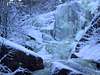
I got back around three in the afternoon, leaving plenty of time to appreciate the view of Zealand Falls from that little side trail with the green sign.
I also got a nice late-afternoon view of Mt Tom from the porch of the hut, but my camera battery chose that moment to succumb to the cold.
Zeacliff indeed provided excellent views.


I hadn't met Michal & Justina yet, so I pressed on. I reached the treed-in summit of Zealand Mountain
Still no sign of them. My original plan had been to turn around by 11:00 so as not to be too late getting back to the hut, but now I started to worry about my friends. Since there was no way they could have passed me without my noticing it, I kept looking for them. Finally, at about noon, when I was almost to the summit of Guyot, I saw them sauntering nonchalantly toward me. Well, since Guyot was so close, I'd go bag the summit and then catch up on the way back.
The clouds were gathering and the wind was increasing, so I and a couple of other hikers who'd been close behind me all day just took a few snapshots and headed back to the hut. I took off ahead of them again since I wanted to catch up to M&J.

Back past the summit spur on Zealand. I'd carved my initials in the snow at the trail junction when I visited the summit, so M&J wouldn't pass me by, then stamped them out when I rejoined the main trail. Figuring they'd do likewise if they stopped, but not seeing any such signs, and figuring they'd be unlikely to leave the main trail anyway since they knew I was coming behind them, I pressed on.
I was getting hungry, but I was concerned that I hadn't yet caught up with M&J, so I didn't stop for lunch. I skipped the Zeacliff overlook to save time. I took off my crampons to go faster on the descents. I made it all the way to the hut in record time, without seeing them. The hut was empty. They'd stopped for lunch in the Zealand summit clearing, of course.
When we were eventually reunited in the hut they told their story. The hike to Guyot Campsite hadn't been too difficult or time-consuming (as I knew, having hiked it both ways that day); it seems that our horrendous pace on Friday was due primarily to hesitant navigation in the dark. They hadn't been horribly cold (as I mentioned in the context of my hike up Mount Hale, it had been a beautiful day), although their breath did cause snowfall inside the tent. Also, I was not too surprised to learn that Michal changed his mind three times about exactly where to set up camp. By not coming along I may have prevented violence that night.
This time we stopped on the summit of Mt Tom. Falling snow closed off the view, so we had to imagine seeing Mt Washington nearby. We did meet a couple of very friendly grey jays, who apparently have learned that hiker = opportunity to steal granola bars.
By the way, the summit spur has a one-way book time of half an hour. We left our bags by the main trail and completed the round trip in forty minutes, including time spent photographing the jays.
We considered also topping Mt Avalon, but given the weather it seemed pointless. Instead we would visit the cascades on the Cascade Loop.


Before then, however, we had one last opportunity to disagree over our route. Near where we were expecting the intersection with the Avalon Trail, an unmarked but heavily-trodden trail diverged sharply uphill to our right (toward Mt Avalon), while a wide, gentle, but less-used trail continued straight. This was perplexing, because I was certain that the junction with the Avalon trail had been marked with a sign on Friday night, and there were no other trails on the map.
Now is a good time to mention that, with the advantage of daylight, we had spotted a handful of badly faded blazes along this trail. Naturally there were none near this intersection.
We went straight ahead, me because I was sure it was the right way, and the others because to go right would have meant an uphill climb. Five minutes later, mystery solved: we were back in that ravine, the one with the infamous gully-on-the-left. The unmarked trail we'd just passed was our own tracks, which several other parties had followed. The actual trail, which we'd missed entirely on Friday, was very narrow and took a diagonal path up a steep and wooded slope, far to the right of where we'd crossed. From below it didn't look like a trail at all. There was a faded blaze, but it was too far back from the stream to have done us any good.
We left some sticks in an arrow shape to indicate the correct trail, and continued to the car. We spent much of the descent marvelling that we'd been able to climb up this way with heavy packs.
The most uncomfortable part of the trip? Crossing the road and the parking lot to get to the car. A cold front was passing through, and once we were out of the trees the wind whipped at gale force, blowing the snow horizontally. In the five minutes we were exposed, I became seriously concerned that my ears were becoming frostbitten underneath my hat.
Perhaps twenty minutes later, as we were driving southward along the highway, the sky cleared. We could see snow still falling to the north of us, but the road back to Boston was simply luminous. I was sorely tempted to head back into the hills because the light was so good for photography, but reality prevailed and we headed home to a hearty dinner.