
-
 4675 Hits
-
 74.01% Score
-
 4 Votes
|
|
Route |
|---|---|
|
|
46.55131°N / 13.24574°E |
|
|
Via Ferrata |
|
|
Summer, Fall |
|
|
Half a day |
|
|
Easy ferrata |
|
|
Rating the Route (By Hiking Standards)

The last meadow in Winkel valley
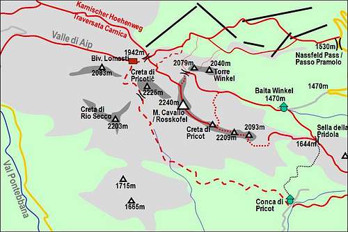
0. General: From Winkel hut, 1470 m to 2240 m, exposition E, N. First by a broad path into the valley end, then across scree slopes and rocky boulders into a ravine where the ferrata starts. On top again easy grassy slopes. By the Austrian 6-grade scale this ferrata is rated A/B. Gear: Good hiking shoes and poles.
1. Effort: cca 800 m, 2 h 30 min.
2. Power: 2 - Easy.
3. Psyche: 2 - Easy.
4. Orientation: 1 - No difficulties, well marked path.
Overview
Ferrata Contin is the easiest ascent on Monte Cavallo / Rosskofel from the valley of Winkel. The valley itself is very nice, especially the meadow at its end. Then the ferrata part is short and easy, nowhere too exposed. From the Contin notch towards the summit we are ascending close to the edge of the wall, having very nice views down in Winkel valley.This approach is in the recent years done by very good tour skiers as a tour which is on the border between an ordinary ski tour and an alpinistic ski descent. In winter the ravine below the Contin notch is filled with snow and thus converted into a snow couloir. The upper part is steep and partially rocky and requires good snow conditions.
Ferrata is named after Enrico Contin, who was in the 70-ies of the last century the president of Pontebba Alpine Club. It was built by his son, the excellent climber Bruno Contin.
Getting There

Baita Winkel
From the meadow, where the hut stands, the marked path continues towards the west. Soon towards the north the path to Madritschen/Madrizze deters, but we continue westwards. Reaching into the basin at the end of Winkel valley, by a big rock there's the crossroads, where we left the F. Schiavi route deters. We continue westwards till the end of Winkel valley.
Route Description

Boulders in Winkel valley

Through the ravine we ascend some 50 meters of altitude. Protections are good, the route is nowhere too exposed.

On Contin notch we are 2044 m high. On the right we already see the summit cross on Torre Clampil. A partially secured (also marked) easy climb leads there up. Towards the right we see the marks of the descent path which later also turns into an easy climbing descent. But our destination is left, towards the summit of Monte Cavallo / Rosskofel. The slopes are not very steep, but intermitted by rocky steps which our ferrata easilly masters. It is winding left-right, choosing the best passages. Occasionally it comes close to the edge on the left, offering great views over the abysses down into Winkel valley. The secured path (we mostly walk up) does so another good 100 meters of altitude, after which the slope becomes flat and grassy. From the right the normal path from Rudnig Sattel / Sella di Aip joins us and to the highest point we have only a pleasant walk up.
Descent: If we have a car on the road, deterring into Winkel valley, then the quickest descent is by the same route. The other option is towards the Austrian side - by the normal path on Rudnig Sattel / Sella di Aip and then by Karnischer Hoehenweg back to Nassfeld Pass / Passo Pramollo. The third option is longer and harder - by the East ridge down on Pridola saddle and further into Winkel valley.