
-
 4691 Hits
-
 74.01% Score
-
 4 Votes
|
|
Route |
|---|---|
|
|
46.55131°N / 13.24574°E |
|
|
Hiking |
|
|
Spring, Summer, Fall, Winter |
|
|
Half a day |
|
|
Mostly easy hike up |
|
|
Rating the Route (By Hiking Standards)
The grading system for hiking and scrambling routes is here.
0. General: From Rudnig Alm, 1612 m to 2240 m, exposition W, N. First by a broad path over grassy slopes on the saddle, then towards the summit over scree slopes and by a not steep grassy and rocky terrain. An overall easy tour, in bad visibility be careful on the summit plateau. Gear: Good hiking shoes and poles.
1. Effort: cca 650 m, 2 h.
2. Power: 1 - Only walk-up.
3. Psyche: 1 - No difficulties.
4. Orientation: 1 - No difficulties, well marked path.
Overview
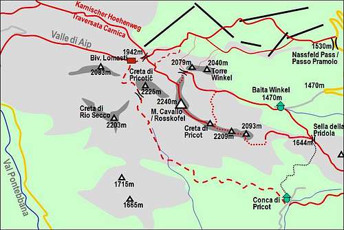
The easiest ascent on Monte Cavallo / Rosskofel goes from the NW, from Rudnig Sattel / Sella di Aip (saddle), 1942 m. While all other ascents must climb at least a few sections of rock, this one goes only over screes and grassy slopes, intermitted with easy rocks. It's only a hike up and if we come high with a car, also a short one. The ascent is very popular and because Monte Cavallo / Rosskofel is such a mighty mountain also a worthwile. The view from the summit is exceptional. This approach can be also done as a ski tour in winter or spring. The only passage which in winter requires some care is the crossing below Creta di Pricotič north face. If that slope is covered with hard snow or even icy, the appropriate winter equipment is needed.
Getting There
Rudnig Sattel / Sella di Aip (saddle), 1942 m can be reached from three sides:
1. From Rudnig Alm, 1612 m. From the parking place (road toll free, 2009) we walk southwards by good paths. Below the main ridge we hit Karnischer Hoehenweg and go by it right on the saddle. 1 h.
2. From Madritschen/Madrizze, 1818 m. From the upper station of cable car we descend towards the west. By Karnischer Hoehenweg we go comfortably below the N walls of Torre Winkel and Torre Clampil towards the west and finally up on the main ridge. 45 minutes. (After we pass Torre Clampil there's a shortcut up, marked, but not well beaten path, which brings us below the N face of Creta di Pricotič. So we gain some 15 minutes or more.)
3. From Passo del Cason di Lanza, 1552 m, or from Casera Caserute, 1425 m. This is the longest approach. We use comfortable paths 439 and 440 through Valle di Aip, bringing us on the saddle in 1 h 30 min.
Route Description
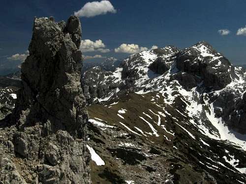
From Rudnig Sattel / Sella di Aip we go by the comfortable path No. 414 towards the SE. In some 10 minutes we are at the beginning of steeper scree slopes below the N face of Creta di Pricotič. We cross them mostly horizontally and in a few turns also upwards. This passage is well seen (from a distance) on the picture on the left.
After the crossing, the path asends more upwards, using the best passages through a predominantly rocky terrain. So we go a bit over rocky steps a bit through small grassy basins, all the time in the SE direction. Some 100 meters below the summit from the left Ferrata Contin joins us. Over flat and broad grassy slopes it is only a few more minutes to the top. 1 h from the saddle. We descend by any of the described routes.