
-
 4060 Hits
-
 71.06% Score
-
 1 Votes
|
|
Route |
|---|---|
|
|
46.55130°N / 13.24570°E |
|
|
Mountaineering |
|
|
Summer, Fall |
|
|
Half a day |
|
|
UIAA I |
|
|
Class 3 |
|
|
Rating The Route (By Hiking Standards)
0. General: From cca 1470 m to 2252 m, exposition E. Marked, but not protected. Difficulties: UIAA I. For less experienced a rope can be useful.
1. Effort: cca 650 m (from the parking place cca 850 m). Only for climbing you will need some 2 h, for the whole ascent from the road 3 h.
2. Power: 3 - Medium
3. Psyche: 4 - Hard
4. Orientation: 3 - Medium.
Approach
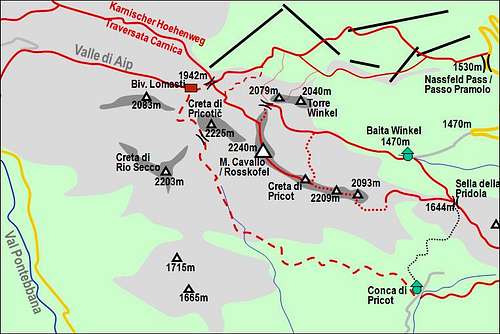
Rosskofel and its routes
See the parent page how to get to Baita Winkel, 1470 m. From the meadow, where the hut stands, the marked path to Sella della Pridola (saddle), 1644 m, deters left. It's broad and well marked (No. 433).
Route Description

Sella della Pridola
On the Sella della Pridola (saddle), 1644 m, our route turns right (westwards). In the beginning we have a comfortable path, going on top of Monte Cavallo di Pontebba / Roskofel's East ridge, which has here some 1700 m of altitude. The path goes through many trenches from the World War I and over a karstic landscape, until it reaches the strong eastern bastion of Monte Cavallo di Pontebba / Rosskofel. On Anticima Est, 1971 m, no easy direct ascent is possible, so the path turns left, making a detour of its eastern side. After passing Anticima Est, the route enters a wild gorge, going between Anticima Est and the ridge more towards the south. This gorge is steep and could only hardly be climbed directly (by its bottom), so our route enters its southern slopes, soon gets exposed, winding up by the gorge. Later the route enters the gorge itself and over washed rocks climbs up. In the whole gorge there's a considerable danger of falling rocks (which can be seen in abundance everywhere). So we reach a notch on top of the gorge.

Easy climbing
From the notch the route turns right and ascends steeply over sunny rocks in the northern direction. If that was a usual path, these details would sure be protected by fixed ropes or cables. But nothing is here, only faithful marks. We climb UIAA I details, go up steep grassy and rocky slopes, the terrain is steep and exposed. On our left we see the southern slopes of the point 2093, a wild steep face of plates. Some 100 m higher we reach a notch, cross it and over steep grassy and rocky slopes ascend up again on the point 2093.

On the ridge
Now a short part of a panoramic East ridge is in front of us. As we approach the point 2203 m we are asking ourselves how the route will overcome its vertical rocks, forming another step on the East ridge. By steep grassy slopes the route goes left and there we find a gully with a fixed rope in it. The ascent is a bit easier with its help and soon we reach the point 2203, where a radio equipment (table) stands. Now the most beautiful part of the ascent is ahead of us. A narrow, exposed, panoramic ridge is leading to the top. We follow it, enjoying broader and broader panorama. Just before the summit of Creta di Pricot, 2252 m, we see where the North Wall Normal route exits, and then we step on the highest point. To the bell on the summit of Monte Cavallo di Pontebba / Roskofel, 2240 m we have some 15 minutes more.
 |
 |