
|
|
Mountain/Rock |
|---|---|
|
|
42.93770°N / 0.28032°W |
|
|
Download GPX » View Route on Map |
|
|
Spring, Summer, Fall, Winter |
|
|
8832 ft / 2692 m |
|
|
Overview
 Cirque du Litor
 Cloudy Cirque du Litor
 Sunny effects
The Gabizos is a mountain of the French mountainside of the Pyrenees, located at the limit of the Béarn and the Bigorre, and whose particularity is to be significantly high and excentred from the border ridge.
Just like its smaller but more famous close brother the Pic du Ger, whose popularity is increased by the proximity of the Gourette ski resort, it is a peak made of sedimentary rocks, mainly brittle limestone and schist slates.
The Gabizos consists in two mountains: the Petit (2639) and the Grand Gabizos (2692). What differenciates them is also the stark contrast of the limestone tone, the Petit being much brighter.
They are separated by a large breach (Pourtet) and are climbed usually separately. Unlike what we can expect, the Petit Gabizos is the hardest of the two, with a steep chimney (brèche Édouard) into which some easy rockclimbing is needed (II UIAA), but on loose stones. A log entry in the Larue hut (see accomodations) relates a fatal accident in it... you are warned !
The Grand Gabizos is also called sometimes "Pic des Taillades", but this name is rather used to designate the jagged ridge that extend north in the direction of the Pourtet breach. This is a famous alpine route, despite slightly dangerous given the rock quality, called "crête des Taillades", and the main reason why mountaineers give the Gabizos a visit.
For the less skilled, the true summit is easily reached by the other side as a simple hike.
On a clear day, the panorama to the Arrens valley and the Balaïtous group on the south are stunning, and justify the visit whatever the route is.
 Summit panorama to the south
Getting There
 Sunny effects
 Sea of clouds
 Hiking down
 Rainy evening
The trailhead is located at the bottom of a small and steep valley called "Cirque du Litor". The trailhead is not visible at all and there is barely the space to park a couple of vehicles.
Another possible trailhead is the Gourette ski resort, but it makes the approach longer.
View Larger Map
Routes
 Taillades ridge
 Southern hiking route
 Cloudy...
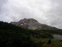 The neighbour Pic de Ger
The Gabizos is usually climbed from two possible trailheads.
Many people start in the ski resort of Gourette, but the most direct, however less known, is via the Cirque du Litor (see Getting There).
Approach, Cirque du Litor
As we park in the bend of the Cirque du Litor, a very shy trail is unexpectedly climbing into the trees and high grass that overlook the road. A long set of very steep laces follows, into grassy pastures. After one hour of restless climb we reach the Larue hut. From there, we can head to the Petit, the Grand Gabizos, or the latter via the Taillades ridge walk.
Approach, Gourette
We leave Gourette via its south end, leaving the sport circuit and the dam and heading into a woody valley (Bois de Saze), whose stream is romantically named "Le Valentin", heading to the Lac d'Uzious. As we leave the forest, we pass two huts : Cabane du Plaa de Batch and Cabane de Coste Goua. At the second, we stop following the trail heading to Lac d'Uzious to elevate SE into a valley that leads to Lake of Louesque (2275). We cross the eponymous pass in order to reach the still-identically-named peak (2554), which makes the start of the southern ridge of the Gabizos, an easy hike to the top.
Approach, Arrens
An alternative route starting from the Estaing dam, in the Arrens valley (Bigorre), is described here. The trail from the Estaind dam heading to Col d'Uzious is marked, and should be followed until the surroundings of the Bassia hut, point from where it is necessary to reach off-route the Louesque peaklet (see previous description).
Petit Gabizos from Larue
The Petit Gabizos is climbed via the "Brèche Edouard", with rock-climbing grade II on loose rock. Description here.
Grand Gabizos from Larue, hiking route
The Louesque ridge described above is easily reached by hiking further up the Larue hut in the south end of the Litor valley.
Crête des Taillades
The Taillade ridges is reached by ascending the Pourtet breach, on a slope of loose gravels. The altitude of the Gabizos is almost reached as we hike up the first bump, but a huge gap appears just after, followed by two others similar in size ! The first gap is passed much easier than it suggests, thanks to a linear hollow running on the side. The second gap is the most impressive as it is the narrowest, and the ascent to the next peaklet is made of a wide flat slate of schists. However, it is easily climbed thanks to cracks in it. The last gap requires the most attention during the way down, and a rope is not odd to assecure partners. The rock is very loose and it's likely that blocs will crash into the valley some hundred meters below. The ascent to the final and real top of the Gabizos is made unexpectedly easy thanks to a bypass on the right with an easy scramble.
Accomodation
 Larue hut
 Larue hut
 Hut-hunting, part of the Pyrenean culture...
 Celebrating...
Wild-camping, bivouacking
No particular red tape as the peak is located out of the National park. The upper Litor valley, unfrequented, is a perfect place. The Lac d'uzious, beautiful lake, despite a bit out of the Gourette route, is also a good spot, and sceneric location.
Unguarded huts
There is a little hut in the Cirque du Litor called Cabane de Larue. In normal circumstances it is not open to hikers, so bringing the tent along is not odd. However, if you have the chance to meeet the sherperds and if you ask politely, you may be offrered a bed.
Another hut, Cabane de Bassia, is marked on the route from Estaing, and reported as open and in good state in 2008. Just below, Cabane de Bouleste, much smaller. Another one at the trailhead (Cabane du Tech is open but austerous.
From Gourette, several huts are marked on the map in the Uzious valley, but none of them is described on the portal www.pyrenees-refuges.com, so they might be private : Cabanes du Plaa de Batch, de Coste Goua, de Congues.
Mountain huts
No mountain hut conveniently located on the usual routes.
Hotels and huts served by road
Two "huts" are marked so on the IGN map, in the centre of Gourette (can they really be called mountain huts...): the Chalet Pyrénéa and the Refuge de Gourette. These are the most likely to fit the needs and budget of hikers. Apart from that, a huge range of accomodations of other standards are available in this ski resort.
Maps
Numeric mapsDue to the copyright policy of the IGN, it is not possible to scan and include map samples without permission. The only way to consult them online is via the database Géoportail, easily browsable via the site ClicGPX (we need to unzoom, move to the central Pyrenees and rezoom again)
Paper maps
Two types of maps are usually found in France for the Pyrenees :
- The TOP 25 series of IGN, high quality maps at the 1/25000 scale, mandatory for hiking off-route. The map that covers the Gabizos is : 1547OT (Aspe/Ossau).
- The Rando Editions series, at the 1/50000 scale. This kind of map is usually enough if we stick to the trails. The map that covers the area is the N° 3 Béarn.

