
-
 29111 Hits
-
 87.31% Score
-
 24 Votes
|
|
Mountain/Rock |
|---|---|
|
|
45.15490°N / 117.2934°W |
|
|
9495 ft / 2894 m |
|
|
Overview

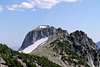
Glacier Peak from Glacier Pass - Late afternoon, August 12, 2004
Glacier Peak stands just 3/4 miles to the SSE of the better known Eagle Cap in the Eagle Cap Wilderness. Eagle Cap completely hides Glacier Peak from Lostine River vantage points as well as most lake basin vantage points. At 9495 Ft. elevation, Glacier Peak is almost a twin brother to Eagle Cap. The peak appears to be seldom climbed probably due to long and difficult approaches compared with other peaks in the area. Nevertheless, this is a very photogenic peak and well worth the effort.
The name is not on the USGS topo nor is it included in "Oregon Geographic Names" but is on some other maps and is known locally. The peak is pictured prominently on the cover of Sullivan's book of Wallowa hikes..
 |  |  |  |  |
Getting There
The primary approach to Glacier Peak is up the East Fork Lostine River trail. Take exit 261 off I-84 in LaGrande and take Hwy 82 toward Enterprise. After about 54 miles, turn right at the town of Lostine at the "Lostine River Campgrounds" sign and go 18 miles to the end of the road. This road starts out paved and progresses to wide gravel then narrower gravel but is a pretty good road as far as such things go. Park at the Two Pan campground trailhead. NOTE: This is a good parking lot but with limited space. You may end up having to park quite a ways down the road if it's busy. This approach requires a summit of Eagle Cap to access Glacier Peak so you get two mountains with one trip!The other approach uses the Wallowa Lake trailhead at the south end of Wallowa Lake. Use the directions as above but keep going on Hwy 82 past Lostine, passing through Enterprise and Joseph. Hwy 82 becomes the Wallowa Lake Hwy in Joseph. Follow it to the end of the road at the trailhead. (about 6 ½ miles from Joseph) This trail is a longer route with more elevation gain to the base of the mountain, but provides a much better (all paved) road to the trailhead.
See details below: "The Long Way" and "The Really Long Way".
There are other, more complicated ways in from the west or the south including one starting at the historic mining town of Cornucopia at the south side of the wilderness area. However, all of these other trailheads are hard to get to, most require much extra elevation gain and loss, and are farther to the base of the mountain.
The Trails: The Long Way and the Really Long Way.
The Long Way: 6,330' vertical, 22.4 miles.
Take the trail up the East Fork Lostine River valley from the Two Pan trailhead to the Lakes Basin junction at the 7 ¼ mile mark. At the junction, a right turn toward Horton Pass soon starts a series of steep switchbacks up the hill. After a mile the trail splits and a well-worn climbers path continues up the ridge to the left. The trail finally drops into a deep saddle then switchbacks up to Eagle Cap's summit.
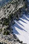
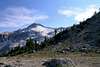
From the summit, drop down the obvious bootpath toward Glacier Peak. The "trail" soon disappears in the rocks, talus and snowfields so continue your traverse towards and slightly left of Glacier's summit. You have a choice at this point: Head up the broad snow field to the left of the serrate ridge (Photo), cross the moat and scramble up the class IV NE ridge (Photo), or: Continue to traverse across alternate bands of granite and snow to the east side of the peak for a class III/IV scramble up the scree/talus. (Photo)
The counterclockwise loop path I took last summer (Map) avoids more than half of the re-climbing in exchange for a traversing cross country trek that was actually marginally shorter than the way I came in - not to mention, it's great scenery!
The Really Long Way:
Take the Wallowa Lake trailhead and proceed up the West Fork Wallowa River. At Six Mile Meadow, take either a left and continue up the river to Glacier Lake or a right, up to the Lakes Basin. (The Lakes Basin route is .3 miles shorter than the loop path shown on the map) If you choose the Glacier Lake option, leave the trail once you get to the lake and traverse cross country around the north side of the lake and up the talus to your goal. If you choose the Lakes Basin fork, take the left hand fork at Douglas Lake towards Moccasin Lake. After you have passed Moccasin Lake, take the left hand fork towards Glacier Pass and traverse directly towards the mountain through the saddle at the west of the pass.
The Glacier Lake option is 27 miles round-trip out-and-back and about 5,000 vertical feet and the Lakes Basin option is 30 miles and about 5,500 vertical. Of course, if you do the loop on the Map and include Eagle Cap, the elevations and distances will be somewhat longer. I've run/hiked all of these routes and they are all beautiful paths through some of the best scenery anywhere so take your pick and enjoy!
 |  |  |  |  |
Red Tape
Trailheads require the usual Northwest Forest passes or equivilent and most roadside camping spots require an additional campsite fee. Both principal ways in have numerous campgrounds. Normal wilderness area rules apply.When To Climb
This looks like it would be a good, but arduous, winter snowshoe or cross county ski-in but the distances are probably daunting and weather here can be extreme. Oregon's all-time record low temperature of -54 was set not too far from this area. I've camped in the lakes basin in August and woke up one morning to find my thermometer reading 17 degrees. (Aug 1983) My taste would make this a summer only trip, from the end of June to the first snows in October.Here's a link for the SnoTel site just north of Aneroid Lake, only 6 1/2 miles away and at about the same altitude as the base of the peak: Aneroid Lake Data