
-
 8420 Hits
-
 79.78% Score
-
 11 Votes
|
|
Route |
|---|---|
|
|
46.50382°N / 7.72079°E |
|
|
Download GPX » View Route on Map |
|
|
Hiking |
|
|
Spring, Summer, Fall |
|
|
Half a day |
|
|
Easy hike |
|
|
Oeschinensee
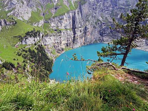 Oeschinensee from Heuberg
Oeschinensee with its neighbourhood is certainly one of the most beautiful corners of whole Alps. A big turquoise lake lies peacefully below mighty, precipitious rocks of Bluemlisalp mountains. Summits, covered by glaciers are rising more than 2000 m above the lake mirror. For example: the vertical walls of Bluemlisalp Rothorn are almost 500 m high and are rising almost out of water on the eastern shore of the lake. Over high rocky slopes many waterfalls are delivering fresh water into the lake. And on the NE side of the lake the world is again different. There are nice alpine meadows with two mountain huts and good paths passing by.
The summits above the lake are mostly unreachable to an average hiker. With scrambling, some easy climbing and much of orientation skills the panoramic summit of Bire, 2502 m, is accessible. It rises just above the town of Kandersteg. And that is more or less all. Very attractive is the long trek from Kandersteg by the lake and further on Hohtuerli pass, 2778 m. On the other side you then descend into Kiental. All the rest exceeds competencies of average hikers - except ascents to mountain huts, which then support more demanding climbs. That is why a big majority of visitors does the tour which is described here - above the northern shore of the lake.
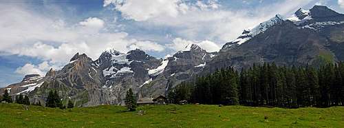
Oeschinensee lies on 1578 m, above the valley step, east of Kandersteg. In the distant past the valley was closed by a big landslade, coming down from the mountains on the northern side. That's how the lake was created. Many mountains in the southern streak exceed the altitude of 3500 m. Those are mighty, glaciated summits. The mountains in the northern streak are almost 1000 m lower, with the exception of Duendehore, 2862 m.
General Information
 The upper path
Difficulty: It's a quite easy hiking tour, with a few places protected by steel cables. On the Swiss Hiking Scale its difficulty would be T2 with a few T3 places.
Orientation: All trails are well marked. See also the GPX track in the header!
Exposition: On the higher path a few places are exposed, but the path is broad enough. If you are on the tour with children, warn them to be attentive enough on those places.
Best season: Spring, summer and autumn. Don't do those long crossings in winter or outside it, when the slopes are covered by snow.
Gear: Good shoes and poles are sufficient.
Tour start: Kandersteg, 1176 m, or the upper station of cable-car, 1682 m.
Highest point: Close to 2000 m.
Altitude to overcome: cca 850 m (450 m).
Time for the round tour: cca 4 h from Kandersteg. Allow enough time to enjoy the scenery!
Getting There
You start the tour in Kandersteg, 1173 m. This tourist resort can be reached from the north, from Thunersee, by a good road, which soon above the town ends. Due to the big UNESCO natural parc, all mountain roads, including the one to Oeschinensee, are closed for public traffic. But if you are travelling across Switzerland, you don't need to return from Kanderstega towards the north. You can simply put your car on a train and get transferred for 22 SFR (2014) through the tunnel into Loetschental, above the valley of Rhone.
While you can not reach Oeschinensee by car, you can reach it by a cable-car. That way you save some 1 h of walk.
Route Description
We best go from Kandersteg to the lake on foot, 1 h. At first to the lower station of cable-car, then across meadows into steep woods. Never mind if you miss the marked path! The road brings you to the lake as well. The ascent direction of marked path is towards the NE, in the vicinity of cable-car. Higher there are a few meadows in the woods, but real alpine pastures start only near the upper station. We don't need to walk just to it. Marks direct us more towards the east on a big pasture where we first see the giants of Bluemlisalp mountains. So we reach a crossroads, 1671 m.
 Bluemlisalp mountains from the pasture near the upper cable-car station
Here you must decide in which direction you want to do the round tour. If clockwise, then go left by the upper road. So, you will first go by the upper path on Heuberg. If we immediately want to see the lake, we go right down. The decision depends on the weather and how good are the views on Bluemlisalp mountains.
Let's go first to the lake! A nice promenade brings us there in 10 minutes. We find ourselves at a nice mountain hut. Its terrace has the most beautiful view far around. That is Hotel-Restaurant Oeschinensee, just above the east shore.
 On the east shore
 On the lower path
From the beautiful meadow below the hotel we continue by the path along the north shore. It is quite rocky and the forrest reaches the shore. Along the path artists created several amusing sculptures. But soon the path starts rising more steeply. So, also the lower path does not go all the time along the shore. It crosses the first waterfall already on its top. Soon after it, the path reaches overhanging rocks, named Holzbalme. The explanatory table teaches us that in the past peasant were keeping there hay, when transporting it from high meadows down to Kandersteg. The path goes by nice, comfortable ledges, all the time with great views on the lake. So we approach the eastern side of the lake and the path reaches nice alpine meadows. We only ascend some more and we already reach the hut on Underbaergli meadow, 1800 m.
 The vertigous ledge
While walking towards Underbaergli, we all the time observed the vertical walls above the east shore. Perhaps we noticed that in the middle a tiny, vertigous ledge is cutting them. And there a path goes also. On the maps it is drawn, but it is nowhere advertised and we could think it is abandoned. But the path is marked and on a few places even protected by cables. For sure it is not for people with weak nerves! That path offers encircling the lake, so reaching the slopes on the southern side. Even if that path promises adventure, only few visitors chose it. The reason is that the views on the lake and mountains above it are far more beautiful from the northern side. Nothing can compare with the glaciers of Bluemlisalp, hanging above Oechinensee! Otherwise that path, after crossing the walls, does quite an ascent, until it reaches on 1936 m the marked path, coming up from the west shore. That path goes further up to Fruendenhütte, 2561 m.
 Underbaergli meadow
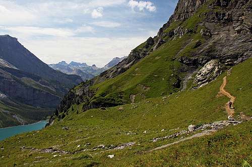
So we are still on Underbarrgli meadow. From it, we shall continue up the valley, towards the north. With a few turns the path reaches a rocky valley step, overcomes it without any trouble and above we are already on the meadows of Oberbaergli, 1978 m. There is a mountain hut as well.
 On Oberbaergli meadow
From it, we can see how close are already the glaciers of Bluemlisalp mountains. Towards the east we already see the upper part of the valley, but to Hohtuerli pass it would be still 800 m of altitude to overcome.
On Oberbaergli we must deter left, on the path which goes back, high above the southern slopes of Oeschinensee. We see the path clearly from the hut. From shepherds huts the path does some more ascent, so in the beginning it goes all the time close to 2000 m. A long, nice crossing is ahead of us.
 On the upper path
The path is extremely scenic! We cross afew steep ravines, we walk by nice ledges above steep slopes, but mostly we cross nice grassy slopes, abundant of flowers. 400 m below us lies the lake and above it the glaciated mountains. The views on them are all the time changing a bit. Overall, the path is easy, suitable for everyone, only a few steeper passages require some additional care. So we approach the grassy balcony of Heuberg, 1940 m.
 Bluemlisalp and Oeschinensee from Heuberg
This one is hanging just above the lake, and offers the most splendid views. A wonderful place, worth of a trip!
From Heuberg the path starts descending. It still crosses towards the west, but we hardly have any views on the lake. Finally we descend on the road, leading towards the cable-car station.