
-
 6355 Hits
-
 78.27% Score
-
 9 Votes
|
|
Mountain/Rock |
|---|---|
|
|
Summer, Fall |
|
|
8504 ft / 2592 m |
|
|
Overview

Hochvogel is one of the most known mountains of Allgäu Alps and therefore one of the most visited summits in this region. Situated in the eastern part of Allgäu Alps, Hochvogel shows from every direction a characteristic shape of a steep pyramid, not unlike the swiss Matterhorn. In fact many people call Hochvogel "the Matterhorn of Allgäu". This characteristic shape, however, is in grave peril, see my “In Memoriam Bäumenheimer Weg” in the routes section below.
Hochvogel is the highest summit of the “Hochvogel / Roßzahn subrange” of Allgäu Alps. In fact Hochvogel is the only frequented summit in this area; nearly all other summits are remote, ragged peaks which rarely receive visits.

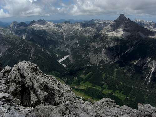
Hochvogel summit marks the border between Germany and Austria. The north route therefore is a “german route”, the southern one largely extends on austrian ground. All surrounding peaks are more then 200 m lower, thus Hochvogel stands out in every direction.
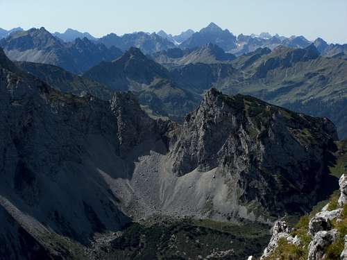
Actually a huge part of the austrian side of the summit rocks tend to fall down into the southwestern valley. Luchily enough this part of the Hornbach valley is not populated. Some years ago the southwest face gets instable and minor rock slides occured. Then suddenly, in 2017, a rock fracture near the summit widened to build a huge and impressive gap. Since then a major rock slide is expected and geologists of Bavaria and Tirol are monitoring closely the situation.


So folks get out and visit this mountain as long as its summit still exist.
Getting There
Trailheads for Hochvogel are:
- Hinterhornbach for the south / southeast route;
- Prinz Luitpold Haus, an alpine club hut north of Hochvogel for the north route.


You reach Hinterhornbach best by car. Railroad and bus connections are poor!
Road number 198 runs along Lechtal Valley between Reutte/Tirol and Arlberg col. Leave this road at Stanzach village and follow the signs to Vorderhornbach and Hinterhornbach. Pass the church at Hinterhornbach and proceed straight on until you reach a switchback and a road junction; there is a small hikers parking area. Fee required.


Trailhead for Prinz Luitpold Haus is the village of Hinterstein.
You reach Hinterstein by car:
- from Kempten, Immenstadt, Sonthofen (road numbers B19, B308) to Bad Hindelang
- from Reutte and Lechtal on road number 198 to Weissenbach and on road number 199 / B308 to Bad Hindelang
At Bad Hindelang turn on Ostrachstraße to Hinterstein. Overnight parking is only possible at parking area “Säge” at the northern entrance of Hinterstein.
For reaching Prinz Luitpoldhaus use RVA-bus number 49 from Hinterstein to Gasthaus Grüner Hut (or alternatively 3 km of walk).
Private bus number 50 goes from Gasthaus Grüner Hut to Giebelhaus (food and drinks).

Follow the closed forest road into Bärgündeles valley until you reach the supply cable car for Prinz Luitpold Haus. Take the left hand trail zigzagging up the east slopes to Prinz Luitpold Haus.
Complicated approach – Hochvogel is a two days undertaking!
Public transportation:
The next railway station for the northern approach is Sonthofen. Bus number 48 goes to Bad Hindelang. Change into bus number 49 at the bus stop Bad Hindelang – Herrenmühle ant take bus number 50 at Gasthof Gründer Hut for Giebelhaus.
Again: complicated approach.
Routes Overview
Hochvogel routes overview:
North / East Route:
From the parking area at Hinterhornbach follow the Hochvogel signposts first on a public road then on a forest road (some switchbacks) until a trail branches off to the left (huge tree, signpost). Follow this trail steeply up the south slopes of the valley, crossing the forest road several times, until you reach an Alm hut. The trail climbs up to a shoulder and a trail junction.


Turn right there and traverse the east slopes of Hochvogel to Fuchsensattel. Descend shortly into Fuchs cirque and ascend on a scree trail (keep always left!) into the so called “Kalter Winkel”, the uppermost part of Fuchs cirque. There is nearly always some snow left. Ascend steeply to the Kaltwinkel col between Hochvogel and Kreuzspitze, the northern secondary summit. There is a fixed rope at the end of the ascend to help you up.
Follow some spectacular but easy ledges up to the broad north ridge of Hochvogel and zigzag up to the summit, some easy scrambling involved.


South route:
From Prinz Luitpold Haus take the southbound trail into the cirque north of Kreuzspitze to a trail junction.
- Go right there and ascend the col between Balkenspitze and Kreuzspitze. A secured short via ferrata (rated A/B) traverses the Kreuzspitze summit into Kaltwinkel col. Proceed as described above to the summit.
- Alternatively take the left hand trail at the trail junction and ascend to Balkenscharte. Traverse near level into Kalter Winkel and proceed as described above for the north / east route.


In memoriam: Bäumenheimer Weg:
This is a real mess and a bereavement! The most interesing ascent to Hochvogel is closed for ever!

Bäumenheimer Weg used the exposed but easy south ridge from Hinterhornbach to the summit and was an easy and exciting climb. Bäumenheimer Weg together with the descent via Kalter Winkel and Fuchsenscharte was a veeeery nice loop traverse of Hochvogel.
Those were the days …. gone is that traverse forever.
Bäumenheimer Weg still exists but is closed. You will read signs about deadly peril when ascending the mountain from Hinterhornbach and there is a final warning at the trail junction above the Alm hut on the shoulder, where the trail to Fuchsenscharte branches off to the right. To the left there was the trail to the south ridge of Hochvogel.


What happened? In 2017 and 2018 a hug gap opened up directly south of the summit cross. It actually runs down several 100 meters on the east and west side of the mountain and is heavily monitored by geologists as it may happen shortly, that the whole southern part of Hochvogel comes tumbling down into upper Hornbach valley. Luckily enough the area threatened by this huge rock slide is no settlement area.
The upper 250 meters of Bäumenheimer Weg will miss when this is going to happen!! So it really is a bad idea to disregard the signs!! The whole southwest rock face of Hochvogel is already destabilized. It is expected that up to 260000 cubic meters of debris will tumble down one day; Hochvogel will then have another shape!
My guess is that the permafrost melting caused the gap, as permafrost glues together many summits with rather frail rock – only think about the brother of Hochvogel, the famous Matterhorn.


Red Tape & Accommodation
The German part of Hochvogel is part of te Nature Protection Area “Allgäuer Hochalpen”.
There is no entrance fee for that area.
Among the regulations for the area is a ban of fires, camping an bivouacing. Please respect those regulations.


Accommodation can be found:
on the south side:
on the north side:


Mountain Huts:
Prinz Luitpold Haus, alpine club hut
Gear & Mountain Condition
Hochvogel can be climbed from early summer through autumn until the first snow falls.
Hochvogel requires on both routes a good stamina and a bit of climbing ability. Good hiking gear with good shoes is sufficient.
The short Kreuzspitze via ferrata on the north route is rated A/B, if you are experienced you need no self belay for that.
Kalter Winkel hosts a very steep snow field throughout the year; depending on the conditions you may need light crampons.


Weather:
Maps
Alpenvereinskarte, scale 1 : 25000:
- number 2/2, Allgäuer-Lechtaler Alpen, östliches Blatt, trails and UTM-grid, edition 2017, or
- number BV4, Allgäuer Hochalpen, trails and UTM-grid, edition 2016
