
-
 26166 Hits
-
 96.98% Score
-
 64 Votes
|
|
Area/Range |
|---|---|
|
|
37.63050°N / 119.0325°W |
|
|
Hiking, Trad Climbing, Sport Climbing, Toprope, Bouldering, Mixed, Scrambling, Skiing |
|
|
Spring, Summer, Fall, Winter |
|
|
8500 ft / 2591 m |
|
|
Overview
The Mammoth Lakes basin lies in the Eastern Sierra Nevada west of Long Valley Caldera near the town of Mammoth Lakes. Its elevation ranges from about 8,500 feet at the north end (Twin Lakes) to about 10,800 feet at its southern end (Duck Pass). It is an all-around paradise for outdoor enthusiasts, with seemingly endless possibilities for hiking, fishing, mountain-biking, cross-country skiing, and others. From the basin one can venture easily into the John Muir or Ansel Adams Wilderness and explore the backcountry of this magnificent area. The basin is surrounded by the Mammoth Crest (Sierra Crest) to the west and the Sherwins to the east, which connect at the southern end. Duck Pass leads over the crest at the south end of the basin into the Fish Creek drainage. Within the basin are numerous beautiful lakes, which eventually drain into Mammoth Creek. From the basin Mammoth Creek drops into the valley flowing east and changing its name into Hot Creek once it enters the Long Valley Caldera. Hot Creek eventually flows into the Owens River.

|
|---|
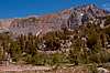
Topography of the Area
| Topography 1 | Topography 2 |
|---|---|
 |
 |
| Topography 3 | Map |
|---|---|
 |
 |
Brief History of the Town of Mammoth Lakes
Prospectors came to this region in their endless search for gold and silver in the late 19th century. The Lakes Mining District was organized on Mineral Hill near Lake Mary in 1877. The following year, General George Dodge organized the Mammoth Mining Co. Over a thousand people flocked to Mammoth City the summer of 1878 and perhaps 1,500 the next. The riches and the bonanza never materialized and the Mammoth Mining Co. shut down its mill in 1880. In the 1890's a different people discovered Mammoth. They were looking for recreation in the Eastern Sierra. Fishing, hunting, photography, camping, hiking, horseback riding were what drew the summer visitors to Mammoth and with them came the businesses to support them. Only a few caretakers stayed to protect the properties that were here during the winter. Mammoth became a quiet and remote area until the completion of a modern highway in 1937. In 1938 the new township of Mammoth Lakes was instituted. Dave McCoy set-up the first 2-rope tow on Mammoth Mountain. At the time, a narrow, winding dirt road up to the rope tow wasn't plowed in the winter. The U.S. Forest Service wanted people to build and develop more ski areas in California's Sierra Nevada range. They put Mammoth Mountain up for bid. No one bid on it, including McCoy, because he didn't have the money. Developers viewed Mammoth as being too risky. "They said Mammoth's elevation was too high, the mountain got too much snow and it was too far from major population area." The Forest Service awarded McCoy the permit by default on the condition that he start developing the mountain. Mammoth was hosting more skiers than any other California operation, including those with chairlifts. After building his first chairlift in 1955 McCoy went on to build one of the largest ski resorts in the country. Today, Mammoth Mountain is a year-round resort. The summer Mountain Bike Park is a popular feature attracting mountain-bike enthusiasts from around the world to challenge its trails.
Lakes
The Mammoth Lakes Basin is a large glacial cirque basin that was carved by the grinding movement of glacial ice and rocks entrained within the ice. The lakes in the lower basin fill depressions in glacial moraine deposits. The lakes in the upper basin fill depressions in the underlying bedrock from metamorphosed sedimentary rocks that were scooped out by glaciers.
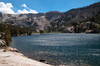
| Twin Lakes | 8,540' |
 |
Only lake which can be accessed by car in summer and winter. Two picturesque bridges cross the lake. At the southern end Twin Falls plunges from Lake Mamie into Twin Lakes. Campground. Fishing and boating allowed. |
| Lake Mamie | 8,900’ |
 |
Lake Mamie lies between Twin Lakes and Lake Mary. The road to Horseshoe Lake passes Lake Mamie. Fishing and boating allowed. |
| Lake Mary | 8,920’ |
 |
The largest lake in the basin. A paved road circles the lake. Pine City and Coldwater campgrounds. Wilderness trailhead at Coldwater Campground at the southern end of the lake. Fishing and boating allowed. |
| Lake George | 9,000' |
 |
Lake George can be reached by a paved road from Lake Mary. Campground. Wilderness trailhead. Fishing and boating allowed. |
| Horseshoe Lake | 8,950' |
 |
Horseshoe Lake can be reached by car from Lake Mamie. Campground closed (Carbon dioxide hazard area). Wilderness trailhead. Fishing and boating allowed. Only lake where swimming is allowed. |
| McLeod Lake | 9,300' |
 |
This lake (sometimes called McCloud Lake) can be reached via a short hike from Horseshoe Lake. |
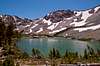
| Crystal Lake | 9,620' |
 |
This beautiful lake can be hiked from Lake George. Lies at the base of Crystal Crag. |
| Lake Barrett | 9,290' |
 |
This lake can be hiked (often in combination with TJ Lake) from Lake George. |
| TJ Lake | 9,290' |
 |
This lake can be hiked (often in combination with Lake Barrett) from Lake George. |
| Heart Lake | 9,620' | Heart Lake lies nestled on the western slopes of the Sherwin Range. It can be hiked from the Coldwater campground. | |
| Emerald Lake | 9,490' | Emerald Lake can be hiked from Coldwater campground. | |
| Way Lake | 9,880' | This small lake can be reached cross country from the trail to Hammil Lake. | |
| Hammil Lake | 10,020' | Hammil Lake lies on the eastern slopes of the Mammoth Crest. It can be reached from Coldwater campground via Emerald Lake. | |
| Arrowhead Lake | 9,690' |
 |
This picturesque lake can be reached from Coldwater campground via a short side trail from the Duck Pass trail. |
| Skelton Lake | 9,920' |
 |
Skelton Lake can be reached from Coldwater campground via the Duck Pass trail. |
| Woods Lakes | 10,080+' | Woods Lakes are a series of small lakes, which can be accessed via cross country from the Duck Pass trail. | |
| Red Lake | 10,220' |
 |
Red Lake is a small lake near Barney Lake and can be easily reached from the Duck Pass trail. |
| Barney Lake | 10,210' |
 |
Barney Lake is the last lake on the Duck Pass trail before reaching the pass. From there the trail zig-zags up to the Sierra Crest. |
Carbon Dioxide Hazard Area
Taken from the USGS website (http://volcanoes.usgs.gov/lvo/activity/monitoring/co2.php)
High concentrations of carbon dioxide (CO2) in soil gas are killing trees on the flanks of Mammoth Mountain at the southwestern edge of Long Valley Caldera. First noted in 1990, the areas of tree kill now total about 170 acres in six general areas, including the most visually impressive tree-kill area adjacent to Horseshoe Lake on the south side of Mammoth Mountain. The soil gas in the tree-kill areas is composed of 20 to 90 percent CO2; there is less than 1 percent CO2 in soils outside the tree-kill areas.
Measurements of the total discharge of carbon dioxide (CO2) gas at the Horseshoe Lake tree kill area range from 50-150 tons per day. Variations are primarily caused by changes in barometric pressure. There is no obvious trend of either increasing or decreasing gas flux at this area; we conclude that the total gas flux coming to the surface at Horseshoe Lake has remained at these relatively high levels since 1996. We do not have enough data from any other gas discharge areas around the mountain to draw conclusions about changes over time at those locations.
Inhaling high concentrations of carbon dioxide gas can cause dizziness, unconsciousness, and death. It is hazardous to dig holes in and around areas where the trees have been killed by carbon dioxide gas. Natural collapse pits that develop on the northwestern shore of Horseshoe Lake as the lake level declines contain high CO2 concentrations - extreme care should be taken to prevent children and dogs from entering these pits or digging up loose soil that has been placed in the pits. Care should also be taken to avoid a crack 1-2 feet wide that extends from the lake onto the west shore. Do not lie face down on the ground anywhere near Horseshoe Lake or the tree-kill area.
As snow levels accumulate in the winter, toxic levels of CO2 can develop in tree wells, around buildings, and immediately below the snow surface in areas of high CO2 emissions. Pay serious attention to signs warning of CO2 hazards.
The most likely sources of the CO2 are degassing of intruded magma and gas release from limestone-rich metasedimentary rocks that are heated by magmatic intrusions.
The CO2 is released as a cool, diffuse gas from broad areas of soil. Although it quickly dissipates when it leaves the ground, CO2 is heavier than air and can collect in depressions in the land surface, in unvented buildings, and in other confined spaces. Carbon dioxide displaces oxygen and can cause unconsciousness or asphyxiation very quickly at concentrations above 30 percent. The National Institute for Occupational Safety and Health recommends a ceiling limit of 3 percent CO2 for up to 10 minutes for occupational exposure. Summer-time exposure to high levels of CO2 in the Horseshoe Lake area may result from lying directly on the ground or digging pits in the ground. Walking through the area in the summertime is safe for children and dogs, as long as their heads stay above ground level. During the winter, CO2 levels can build up beneath the snowpack and the CO2 gas will preferentially escape around buildings, through tree wells, and through depressions around large rocks. Such areas should obviously be avoided, as should snow camping within tree-kill areas.
| Carbon Dioxide Hazard Area |
|---|
 |
Wilderness Trailheads
From the Mammoth Lakes basin trails lead into the John Muir Wilderness to the south and the Ansel Adams Wilderness to the west. There are three popular Wilderness Trailheads in the lower basin.
| Crystal Crag Trailhead | 9,010 |
 |
This trailhead is located on the north side of Lake George near the parking lot. From there you can hike to Crystal Lake (9,650’, 1.5 miles) and Crystal Crag and further to the Mammoth Crest (10,400’, 3 miles). From the Mammoth Crest you can hike on the west side of the crest south towards Deer Lakes. You will enter the Ansel Adams Wilderness at the Crest. |
| Mammoth Pass Trailhead | 8,950’ |
 |
This trailhead is located at Horseshoe Lake. From there you can hike to McLeod Lake (McCloud Lake) (9,250’, 0.5 miles) and further cross the the Mammoth Crest at the Mammoth Pass. From the pass you can hike further west towards (Upper) Crater Meadow, Red Cones, and Reds Meadow and other destinations in the Middle Fork San Joaquin River Valley. You will enter the Ansel Adams Wilderness at the Crest. |
| Duck Pass Trailhead | 8,960’ |
 |
This trailhead is located at the very south end of the Coldwater Campground near Lake Mary. You should not confuse this trailhead with the trailhead to the Emerald Lake, which is close nearby. From there you can hike to Arrowhead Lake, Skelton Lake, Barney Lake and others along your way to Duck Pass. At Duck Pass you cross the Sierra Crest and enter the Fish Creek Drainage. You will enter the John Muir Wilderness shortly after the trailhead. |
Campgrounds
There are five developed campgrounds in the lower Mammoth Lakes Basin. Remember that this is bear country and you should and are required to practice safe food storage techniques. Bear-proof food containers are available at every campsite. Non-compliance will be fined. The dates for opening below are of course an approximation depending on the snow cover. For reservations of Inyo National Forest Campgrounds, call: 1-877-444-6777
| Twin Lakes | 93 sites | The campground has two sections - Twin Lakes and Upper Twin Lakes, on the west and east shores of Twin Lakes. The Upper Twin Lakes section is the smaller of the two and closest to Twin Lakes General Store. Flush toilets. Open May 25 through October 28. Rate: $21 per day; Maximum Stay Permitted (days): 7 |
| Horseshoe Lake | closed | This campground is closed from camping due to the carbon dioxide hazard in this area. |
| Lake George | 16 sites | This campground is on the northeast side of Lake George. Flush toilets (some are wheelchair friendly). Open June 8 through September 9. Rate: $21 per day; Maximum Stay Permitted (days): 7 |
| Lake Mary | 48 sites | This campground is on both sides of the road between Lake Mary and Lake Mamie on the northern shore of Lake Mary. Flush toilets. Open June 8 through September 9. Rate: $21 per day; Maximum Stay Permitted (days): 14 |
| Coldwater | 76 sites | This campground is south of Lake Mary and can be accessed by a paved road. Sites are located either along Coldwater Creek or Mammoth Creek. Flush toilets. Open June 8 through September 16. Rate: $21 per day; Maximum Stay Permitted (days): 14 |
| Pine City | 10 sites | This campground is on the eastern shore of Lake Mary. Flush toilets. Open May 30 through September 21. Rate: $21 per day; Maximum Stay Permitted (days): 14 |
Getting There
From the north or south you will approach the town of Mammoth Lakes via US highway 395. Exit on state highway 203 (Mammoth Lakes) and drive west into the town (Main Street). Follow Main Street past Old Mammoth Road (going left, south) and Minaret Road (going right, north). The street changes its name to Lake Mary Road. Follow the road up the southeastern slopes of Mammoth Mountain to the Lower Mammoth Lakes basin. Twin Lakes are the first lakes you will see.