
-
 4728 Hits
-
 78.27% Score
-
 9 Votes
|
|
Route |
|---|---|
|
|
46.43971°N / 13.65489°E |
|
|
Hiking, Scrambling, Via Ferrata |
|
|
Summer, Fall |
|
|
A long day |
|
|
T5/T4 on the Swiss Hiking Scale |
|
|
Introduction
The ascent from Koritnica valley and further by the East Ridge on Mangart is a long, but beautiful one. It brings us into a very remote and wild area between the two giants of Julian Alps (Mangart and Jalovec). The upper part of the tour is also very panoramic, as we are climbing up by a high ridge with views completely opened towards the north and south. Rather than as an independent tour, the tour is more often done as a part of trekking across Julian Alps.
General Information
Difficulty: It's a hiking tour, with many places of easy, but quite exposed climbing. Some such places are protected by steel cables and pegs. On the Swiss Hiking Scale its difficulty is graded T5/T4. Technically the most challenging are the rock passages in the vicinity of Huda škrbina (notch). Protection devices along the path were renewed, but the route is overall only scarecely protected.
Orientation: From the very beginning to the top we can follow the usual Slovenian (Knafeljc) red-white marks. Also these are not in abundance, so on some places a bit of orientation skills is needed. Maps to be recommended: Tabacco No. 19. 1:25.000. Planinska zveza Slovenije: Mangart - Jalovec. 1:25.000.
Exposition: Some places are very exposed and so not appropriate for people suffering from vertigo. On the sections of crossing steep grassy slopes protection with rope is difficult.
Objective dangers: There are not many.The usual care is needed regarding falling rocks. Never go on this ridge tour in danger of storm and lightning!
Best season: Summer months, normally from July till October (or first snow). In autumn be careful due to shorter days!
Gear: Good shoes and poles are sufficient. For less experienced on short ferrata sections the ferrata equipment might be useful.
Tour start: The end of the road into Koritnica valley, 850 m. You deter into the valley just above the village of Log pod Mangartom.
Highest point: 2679 m.
Altitude to overcome: cca 1850 m.
Time for ascent: 6 h 30 min.
Tour Logistic: When planning this tour, have in mind the return. Returning by the same route is almost nonsense. It is best to descend from the summit of Mangart by the normal route (by the italian side), in 1 h 30 min you can reach Mangartsko sedlo / Forcella Mangart and in less than 2 h the mountain hut (Koča na Mangartu, 1908 m). One interesting idea is that bikes are waiting you there (or a second car). But, as the mountain road to the hut is payable, it is likely that you will either sleep in the hut or hike down in Koritnica from there. A non-marked ex shepherds and hunters path is the shortest one. It starts on the road, then passes north of Mali vrh, below Rdeča skala and further towards the southeast directly down into the valley. From the hut it's some 1.000 m of a descent (not just easy). Going around by the road is much longer.
 The route and its sections.
Route Description
1. Parking place, 850 m - below Hudi žleb, 1350 m. 1 h 15 min, T1.
From the parking place you simply continue into the valley, ascending gently. Soon the marked path on Čez Brežice deters right, there you continue ascending towards the NE. So you reach a more flat part of the valley (Lanžev plaz), just below the distinct ravine of Hudi žleb (this one is going northwards).
2. Below Hudi žleb, 1350 m - path branching, 1700 m. 1 h, T2.
On the upper part of the plane you have two choices: the unmarked hunters path and the marked path. The latter continues right by the valley. Soon it ascends the scree slopes, falling from below the W walls of Kotova špica. On some 1700 m from the right the marked path from Kotovo sedlo joins (in descent).
3. Path branching, 1700 m - path branching, 1900 m. 30 min, T3.
We continue towards the valley end (northwards), ascending quite steep and tedious scree fields. Higher, below Kotova špica walls, the path keeps left and soon from the left the already mentioned hunters path joins. It is not marked and continues up, towards Rob nad Zagačami / Forcella Zagherza (notch).
Alternative - hunters path (1350 m - 1900 m). 1 h 30 min, T3.
Soon after the flat valley part below Hudi žleb ravine from the marked path a well beaten hunters path deters towards the north. It is not marked, but goes more comfortably in many switchbacks below the walls of Mangart towards the north-east. On 1900 m it joins the marked path.
 On the southern slopes of Mali Koritniški Mangart
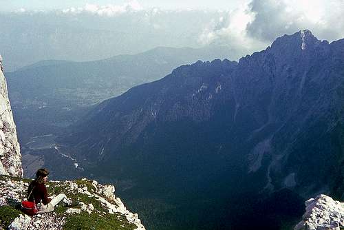 On Huda škrbina (notch)
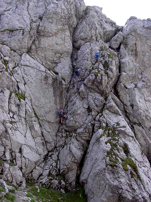
4. Path branching 1900 m - Huda škrbina, 2362 m. 1 h 15 min, T5.
From the place where the hunters path joins the marked path, we continue by the latter in the northern direction. By steep grassy slopes we ascend almost 200 m, until on the slopes of Mali Koritniški Mangart a marked path deters right. It goes to the nearby Rob nad Zagačami / Forcella Zagherza (notch), where Bivouac Tarvisio stands. But we continue left across the steep grassy and rocky slopes of Mangart. The direction is westwards. The first part of this crossing is still not too difficult, but when we reach the rocks of a short side ridge before Huda škrbina, going around the edge becomes tricky. The passage is very exposed, scarecely protected and requires some climbing skills. There is even a tunnel on the path. So we gain the main ridge between Mali Koritniški Mangart (on the east) and Mangart (on the west), and soon also the picturesque notch of Huda škrbina / Mala Forca. Towards the south, the steep, wild ravine of Hudi žleb falls and by all means it is worth going also on the panoramic ledge, hanging over the northern walls of Mangart massif. It is there where the Gamsov rob / Sperone del Camosci side ridge comes up. The views down on Mangartska dolina and its lakes are wonderful!
 Saman - The rocks near Huda škrbina Saman - The rocks near Huda škrbina |
 Koritnica valley Koritnica valley |
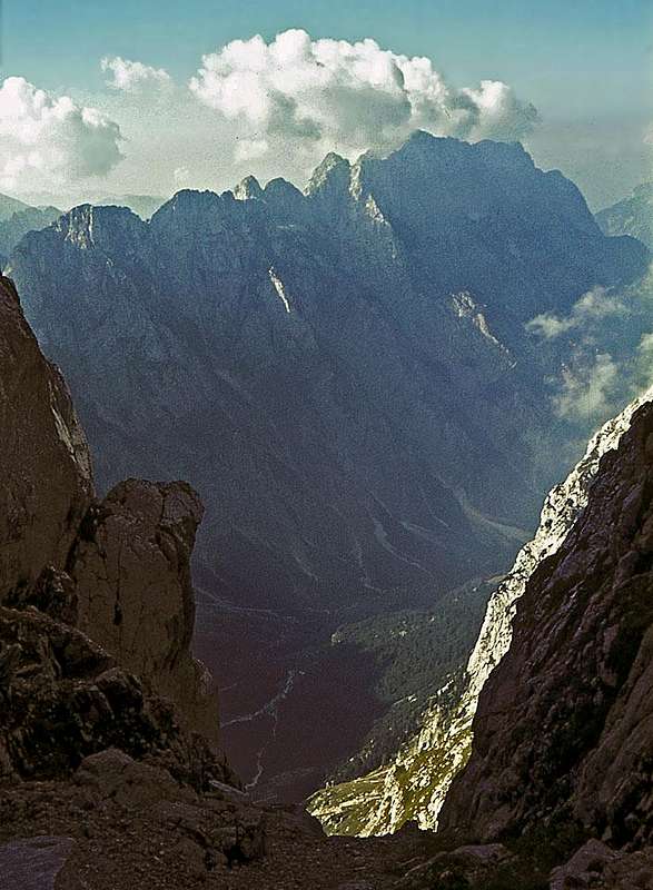
 Mangart East Ridge from near Huda škrbina
5. Huda škrbina, 2362 m - Mangart, 2679 m. 1 h, T4.
From Huda škrbina the path can not follow the East Ridge of Mangart. It soon starts crossing its southern slopes, but also that traverse is far from being easy. The grassy slopes are very steep and exposed, the path is tiny and quite some care is needed. After that passage the path starts ascending towards the main ridge. It becomes a bit less exposed and where reaching the main ridge and thus the normal approach, all the difficulties are behind us. We only need to gain the last meters of altitude - by the foresummit on the highest point.