
-
 4406 Hits
-
 81.18% Score
-
 13 Votes
|
|
Mountain/Rock |
|---|---|
|
|
42.87719°N / 0.47675°E |
|
|
Download GPX » View Route on Map |
|
|
Hiking, Skiing |
|
|
Spring, Summer, Fall, Winter |
|
|
7044 ft / 2147 m |
|
|
Overview
 Mont Né seen from Hourgue de la Fausserette Mont Né seen from Hourgue de la Fausserette |
It doesn't always have to be the highest mountain to obtain the best views. More often a medium sized but perfectly placed lower mountain is better equipped in terms of vista. If you go to the Bas-Luchonnais region north of the Pyrenees main ridge you'll find a whole ridge of these mountains, located south-east of Arreau between Valée de Louron and Valée de Luchon. The ridge cradles one of the most popular lakes in the region in its midst, Lac de Bareilles and consists of some eight round-topped mountains all of which reach more than 2000m. The highest of these mountains is Montious to the west of the lake, the next in line is Mont Né on the opposite side.
Mont Né certainly is no beauty. It's round top rises 400m above Lac de Bareilles and can be easily reached by a well maintained hiking trail within less than an hour. The trail passes Port de Pierrefite, a saddle which separates the French departements Haute Garronne and Hautes Pyrenées. Mont Né, also on the departmental border is located several hundred metres above and to the north of the saddle. Alternatively you can reach the mountain by a slight detour by following a path to the south of Lac de Bareilles to Col de Lion (2102m), from where a long ridge traverse starts across Pic du Lion, Hourgue de la Fousserette (2072m), Mont Né (2147m), Soum du Templa (2121m), Montagne du Pin (2001m) and Montagne d'Areng (2079m).
 |  |  |
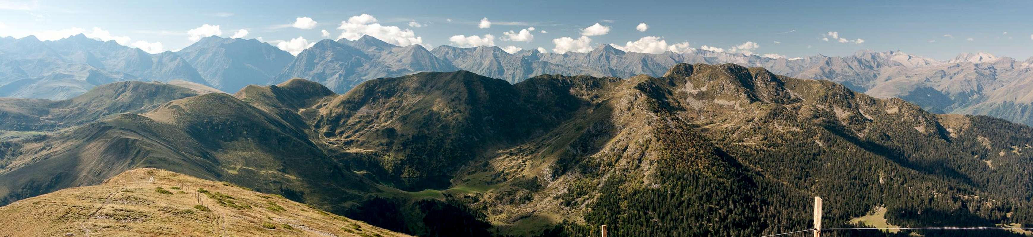
Along the whole traverse you will have perfect views of the mountains of the Bigorre and Luchonnais regions of the Pyrenees. There are no higher mountains close by so that you'll be able to see all mountains in a wide half circle between Pic du Midi du Bigorre in the north-west to Aneto in the south-east. Even though the traverse is neither difficult nor long it will take a long time for the many rests one has to take to view the vista.
 |  |  |
Nota Bene:
The Bas Luchonnais region to the east and north is a hill country, which awakes from its slumber in summer, when the Tour de France almost invariably will pass close by at Col de Peyresourde or Port de Bales (or both as in 2012).
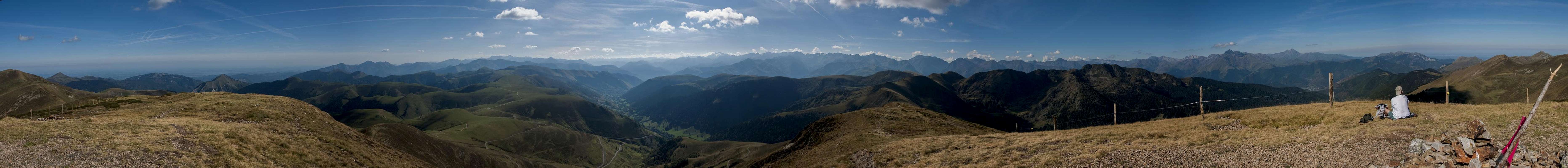
360° Summit Panorama
  |
Getting There
 Montious, Lac de Bareilles, Mont Né seen descending Pic ddu Lion
Access routes by car (by visentin)
- From France
- Take motorway A64 to the exit Lannemezan
- Take D929 to Arreau
- Switch To D112 which leads through Bareilles turning into a dirt road right after the village.
- Park the car near the Bergerie d'Artigue Longue
- Alternatively you can drive from Arreau across Col de Peyresourde to Saint Aventin, where the road into Valée d'Oueil turns off to the right. At the very end of the Valley, at Port de Bales tere is another possible trailhead.
- From Spain
- Take motorway A22 to Monzón
- Switch to N240 to Barbastro
- Switch to N123, later A138, which leads through Bielsa and the Bielsa Tunnel to France
- Take D173, D929 through St. Lary-Soulan to Arreau.
- Switch To D112 which leads through Bareilles turning into a dirt road right after the village.
- Park the car near the Bergerie d'Artigue Longue
Red Tape
There's no red tape. Lac de Bareilles is a very popular picnic destination so you'll run into flocks of tourists there. Along the ridgelines the flocks turn into sheep ;-)Accommodation
 |
Weather Conditions
Maps & Books
- Luchon - Comminges - Louron
1:50000
Rando Editions
ISBN: 978-2-84182-343-7
- Pyrénées Centrales V
Vallées d'Aure et de Luchon
Guide Ollivier
Editions Cairn
ISBN: 978-2-35068-173-3
- Pyrenäen 2 / Pyrénées 2
R. Büdeler
Rother Verlag
ISBN:
978-3-7633-4308-9 (German)
978-3-7633-4918-0 (French)
978-3-7633-4826-8 (English)