
|
|
Mountain/Rock |
|---|---|
|
|
42.69616°N / 0.46933°E |
|
|
Hiking, Mountaineering, Trad Climbing |
|
|
Summer, Fall |
|
|
9908 ft / 3020 m |
|
|
Overview
Clarabide is not a single peak, but a small ridge placed between the spanish valley of Estós and the french Val Louron. Its limits are two cols placed over 2900 meters above sea level: the Col de Gias (between Clarabide and the Gourgs Blancs massif) and the Brecha de Gias (between Clarabide and Pico de Gias). The altitude of the main summit is 3020 meters, and there are also two secondary summits: East Clarabide (3012 m) and West Clarabide (3008 m). The area is rather wild, not too crowded, as Aneto and Posets are rather close, and the approach via the valley of Estós is simply beautiful.Getting There
Driving your own car: Wherever you start driving, the entrance to the valley of Benasque is the spanish city of Barbastro, easily reachable from Huesca or Lleida and placed about 40 km east of the former. Once you get to Barbastro, take road N123A and follow it up to the signposts marking the deviation towards Graus. Once you get to this small city, just follow road A139 northwards for an additional 59km and you will get to Benasque.By bus: Benasque is served by the bus company ALOSA. There are only two daily buses, arriving to Benasque at 13.00 h (1.00 p.m) and half past seven in the afternoon (19.30 h)
By train: The closest train stations are placed at Huesca (140 km away from Benasque) and Lleida (141 km). Additional transport shall be required from those points onwards.
By air: The nearest airports are placed at Barcelona (293 km), Zaragoza (230 km) and Huesca-Pirineos (140 km). The biggest one, and therefore served by a bigger number of airlines, is the Barcelona Airport. There are direct low-cost flights from London Stansted to Zaragoza, and Huesca-Pirineos is only served by Pyrenair (see External Links section).
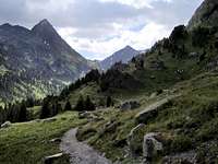
When you reach Benasque you will still have some kilometres to go (say four to six…) on the road northwards. Just after crossing the bridge of San Chaime (Puente de San Chaime), there’s a dirt road leading to your left (westwards) marked by the red-and-white signs of the GR11 trail. An additional two kilometres on that dirt road will place you in the parking area (near some barracks, about 1300 meters above sea level). Leave the car there and start hiking up the valley towards the Refugio de Estós.
Red Tape
The mountain and its southern access are included in the spanish natural park of Posets-Maladeta. All usual measures are therefore enforced in order to protect nature, and this includes the prohibition to set stable camps. As far as I know, night time bivouac is allowed, meaning that you can set up your tent in the late afternoon and put it down first thing in the morning.Huts

Three huts can be found in the spanish (southern) access to the mountain, along the valley of Estós. The main one is the refugio de Estós, guarded all year round. But there are also two smaller huts. The lower one is the cabaña de Santa Ana, 1540 meters high and placed about 45 minutes into the valley after leaving the parking area. It’s not rare to find it open, therefore providing shelter from unexpected storms. The upper hut is the cabaña del Turmo, 1730 meters high and placed about 1h 45 minutes away from the parking, approximately 15 to 30 minutes before the refugio de Estós. This is a shepherd’s hut, normally in use and therefore closed.
External Links
ALOSA: Web page of the bus company offering transport to Benasque. Only spanish language, sorry about that...Pyrenair: Airline serving the Huesca-Pirineos airport
visentin - Sep 3, 2009 4:33 am - Voted 10/10
french routeI can add it, I have pictures of this route
eza - Sep 3, 2009 4:59 am - Hasn't voted
Re: french routeIt's all yours, Eric, thank you. I'm glad to know you can complete the SP outlook on Clarabide. One more thing: if you don't mind, I would like to borrow some of the info you can give about "getting there" to the french trailhead and include it in the main page of the mountain