
-
 3427 Hits
-
 79.78% Score
-
 11 Votes
|
|
Mountain/Rock |
|---|---|
|
|
46.30761°N / 11.79524°E |
|
|
Hiking, Skiing |
|
|
Spring, Summer, Fall, Winter |
|
|
7654 ft / 2333 m |
|
|
Overview
 Monte Castellaz in the first morning light
 |  |  |
Whatever convinced me – in 2018, 13 years later, I was surprised when browsing my guidebook and stumbling upon a 3-4h hike from Passo Rolle to the summit of said mountain, effectively circling it using two routes on its western and eastern sides. As Passo Rolle can be easily reached and has several huge parking lots (for the winter ski crowds), the idea was born to go there, climb it and afterwards search for a second target to fill the rest of the day. The second target turned out to be Monte Cavallara on the other side of the pass but that’s another story.
Passo Rolle and the pastures of Malga Venegiota and Malga Venegia are famous for their impressive views of the northern chain of the Pale di San Martino with its two highest mountains, Cima della Vezzana and Cimon della Pala. Especially the latter forms a narrow tower-like pyramid of more than 1000m height. Monte Castellaz is located directly in the sweet spot to the north-west of the chain, thus offering some of the best views you can encounter in all the Dolomites.
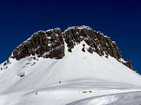 |  |  |
As mentioned above Monte Castellaz – like its name implies – resembles a huge castle with big bastions and promontories. On three sides vertical faces prohibit an ascent but to the north there is a weak spot, from which the summit is accessible. It is still a steep and rocky trail which levels out near the summit where the statue of Cristo Pensante (Pensive Christ) guards the remaining ascent to the summit.
 |  |  |
In WW I Monte Castellaz was fortified by Italian Alpini to protect Passo Rolle together with similar artillery positions on nearby Monte Cavallara Piccola. The whole summit area is carved out into ledges and the access trails bear witness of that violent time 100 years ago. A bit further down in the north-east face there is even a large cave which was used to host men and provisions. On Malga Venegiota to the east of Monte Castellaz you still can find the foundations of a set of military barracks, which served as bases for the artillery positions on the summit.
Tip: if you are looking to enjoy the amazing panorama, rather climb Monte Castellaz in the afternoon. While morning climbs are far less crowded the sun will be rising behind the northern chain of Pale di San Martino thus spoiling the best part of the 360° panorama.
360° Summit Panorama
  |
Getting There
 Monte Castellaz above Passo Rolle and in front of the Marmolada Group
- Take motorway A13 to the exit Padova South or Padova West
- Switch to SS47 della Valsugana (in the direction of Bassano/Trento) up to Cismon del Grappa
- Take SS50bis (in the direction of Feltre/Belluno) up to Agana
- Switch to SS50 to Mezzano, San Martino and Passo Rolle
- Take highway SS50 west which will take you all the way to San Martino and Passo Rolle
- li>Take motorway A22 to exit Trento center
- Switch to SS47 della Valsugana (in the direction of Bassano/Trento) up to Cismon del Grappa
- Take SS50bis (in the direction of Feltre/Belluno) up to Agana
- Switch to SS50 to Mezzano, San Martino and Passo Rolle
- Take motorway A22 to the exit Egna-Ora
- Switch to SS48 in the direction of Val di Fiemme and Val di Fassa
- At Predazzo change to SS50 to Passo Rolle
Routes
There is one loop trail from Passo Rolle, which effectively heads up the mountain from the northern side. Several switchbacks take you up to Rifugio Carpanna Cervino to the south of the mountain. A few hundred metres further on the route splits into the western trail, which negotiates the slopes underneath the west face before steeply rising across blocky slopes towards the statue of Cristo Pensante. |  |  |
Alternatively you can head onwards from Rifugio Carpanna Cervino to Baita Segantini where you have to turn north-westwards, cutting across the slopes of Malga Venegiota. After crossing a shallow valley you come across the foundations of WW I barracks, where the trail starts to rise, to head for Monte Castellaz` north face. A few switchbacks take you past a big WW I cave and up a scree covered path towards Cristo Pensante. From here a few scrambling steps take you to the summit proper.
When to Climb
 Catena di Lagorai as seen from the summit of Monte Castellaz
Red Tape
The Pale di San Martino Group is located within the park boundaries of the Parco Naturale Paneveggio - Pale di San Martino.The natural park consists of the area of the Pale di San Martino Group as well as the forest of Paneveggio and the porphyritic Catena di Lagorai. It contains an area of 125 sqare km which in 1987 has been divided in three different levels of protection:
33% of the area have been assigned complete protected areas,
60% are restriced areas while
7% are controlled area.
Still, there is no real red tape around Passo Rolle. This is a ski area, so it seems like almost anything is allowed. While the dirt roads around the mountains are surely off limits you’ll often encounter cars parked at Baita Segantini. The huts and ski lifts also are often served by delivery vans. Bottom line: you rather have to find paths on which you can avoid any upcoming traffic.
Accommodation
For Hotels and appartments have a look at the websites of the towns and villages of the region:Weather Conditions
Maps & Books
Maps
- Pale di San Martino
Kompass Map WK 622
ISBN: 3 8549 1548 9
Scale: 1:25000
- Pale di San Martino
Kompass Map WK 76
ISBN: 3 8549 1086 X
Scale: 1:50000
- San Martino di Castrozza e le zone adiacenti
Carta delle zone turistiche d'Italia
Touring Club Italiano
Scale 1:50000
- Pale di San Martino
Tabacco Map 022
Scale: 1:25000
Books
- Dolomiten 8
F. Hauleitner
Rother Verlag
ISBN: 978-3-7633-4524-3
- Höhenwege in den Dolomiten
H. Dumler
Bruckmann Verlag
ISBN: 3 7654 3860 X
- Dolomiten
P. Fleischmann
Kompass Verlag
ISBN: 3 8705 1409 4