
-
 10835 Hits
-
 85.87% Score
-
 21 Votes
|
|
Mountain/Rock |
|---|---|
|
|
34.30580°N / 118.0075°W |
|
|
Los Angeles |
|
|
Hiking |
|
|
Spring, Summer, Fall, Winter |
|
|
5840 ft / 1780 m |
|
|
Overview
Mt. Mooney has a nicely rounded and partly forested summit with views over Charlton Flats to the southwest and part of the San Gabriel range to the east. The area north of the summit is wonderful open pine forest. The peak was named for Joseph Mooney, an Angeles Forest Service ranger who died in military service in France during WW1.
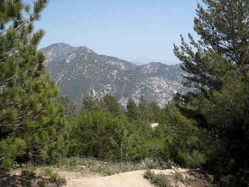 View east from near summit of Mt. Mooney
This is an easy 2.4 mile round trip with about 450 feet of gain on a dirt road that begins just northwest of the Charlton Flats Picnic Area entrance road off of the Angeles Crest Highway. From the parking area on the south side of Angeles Crest Highway adjacent to the Charlton Flats entrance road (5393’), cross to the north side of the highway and walk about 100 yards west. Turn onto a paved road on the right. At an immediate fork, stay right. The road becomes dirt in .1 miles. In .6 miles, you will come to a wide flat area on the ridge top at about 5600’. (You can actually drive to this point and park here, but I’m assuming you like to hike.) Turn left going over a small dirt berm onto a jeep road that goes west. Follow the road about ½ mile to the summit.

Pine Forest below Mt. Mooney

View towards Charlton Flats just below Mooney's summit
As an option to the jeep road route that takes you northeast and then west, you could head directly north straight up Mooney’s brushy south ridge. This route is probably ½ mile shorter than the road.
Getting There
From the 210 Freeway, exit at Angeles Crest Hwy (SR 2) and go north. At 9.5 miles, you will come to the Clear Creek Information Station and junction with Angeles Forest Highway. Continue straight and in 4.5 more miles you will come to the junction with the Mt. Wilson Road at the Red Box Ranger Station and trailhead. From here, continue straight on SR2 for 9 miles more to the signed Charlton Flats Picnic Area on the left. There is paved parking adjacent to the entrance road to the picnic area. Do not proceed into the picnic area.
 View along Angeles Crest Highway near Silver Mocassin trailhead
Red Tape
You will need an Adventure Pass (see link below) to park your vehicle anywhere within the Angeles National Forest, including the parking area mentioned here. These passes are currently sold at the Clear Creek Information Station and the Red Box Ranger Station ($5 per day or $30 for a yearly pass), which stations you pass on the way to the trailhead. Otherwise, Adventure Passes are also sold at most sporting good stores in Southern California.
No permits are required for hiking.
Camping
There are campsites in the vicinity of the Chilao Visitor’s Center about 3 miles north of Charlton Flat off of the Angeles Crest Highway.
When to Climb/Mountain Conditions
All year round. However, equip yourself appropriately when there is snow cover in the winter.
Check forecast information in local newspapers or internet weather services during the winter months. Check with Cal Trans (see link below) on road conditions and closures.
Other Information
USGS Topos Chilao Flat 7.5
External Links
Angeles National Forest
Adventure Pass information
California Dept. of Transportation
T. White - Jul 20, 2019 4:51 pm - Hasn't voted
Road has deterioratedI think a notice should be posted on this page about current conditions on the Mount Mooney Road. Erosional gullies have made it completely impassable for 2WD cars, and even my Crosstrek had major difficulty getting through them.