
-
 12976 Hits
-
 83.69% Score
-
 17 Votes
|
|
Mountain/Rock |
|---|---|
|
|
34.35850°N / 117.9357°W |
|
|
Los Angeles |
|
|
Hiking |
|
|
Spring, Summer, Fall, Winter |
|
|
7502 ft / 2287 m |
|
|
Overview
Winston Peak is a high point on a ridge by the same name in the high country of the San Gabriel Mountains. The ridge and the peak bear the name of a Pasadena banker who lost his life in a blizzard while on a hunting trip at the turn of the previous century. In the 1890’s, it is said that deer and bear were plentiful in Cooper Canyon, to the east of Winston Peak. In any event, Mr. Winston’s frozen remains were discovered on this ridge in 1900.Because this peak is only just over ½ mile from the Cloudburst Summit trailhead (7,018’), with 500 feet of gain, a hike here should be combined with a visit to Winston Peak’s nearby neighbor, Winston Ridge (6,903’). Winston Ridge summit is just northeast of Winston Peak as you descend along the ridge.
From the parking area at Cloudburst Summit, as you face north, simply start hiking northwest up the ridge that begins above and to the left of a fire road gate.
 Ridge to Winston Peak
On the ascent, you will get some excellent views towards the eastern San Gabriel range as shown in the photo below.
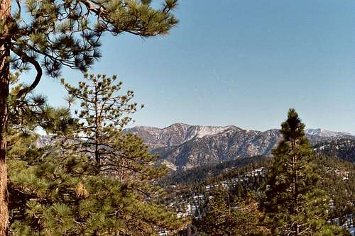 View East from ridge to Winston Peak
Directly south of your location on the ridge are Waterman Mountain and Twin Peaks. When you get to the summit, you will see Winston Ridge continuing northwest.
 Winston Ridge (middle) from Winston Peak
Wander around the summit area a little bit to gain some great vistas of the desert toward the northwest.
 View NW towards desert from Winston Peak summit
Getting There
From the 210 Freeway, exit at Angeles Crest Hwy (SR 2) and go north. At 9.5 miles, you will come to the Clear Creek Information Station and junction with Angeles Forest Highway. Continue straight and in 4.5 more miles you will come to the junction with the Mt. Wilson Road at the Red Box Ranger Station and trailhead. From here, continue straight on SR2 for 19 miles more to the signed Cloudburst Summit. There is a parking area on the left side (north) of the road.Red Tape
You will need an Adventure Pass to park your vehicle anywhere within the Angeles National Forest, including this trailhead. These passes are currently sold at the Clear Creek Information Station and the Red Box Ranger Station ($5 per day or $30 for a yearly pass), which stations you pass on the way to the trailhead. Otherwise, Adventure Passes are also sold at most sporting good stores in Southern California.No permits are required for hiking in the area described here.