
|
|
Mountain/Rock |
|---|---|
|
|
34.21318°N / 117.96861°W |
|
|
Hiking |
|
|
Spring, Summer, Fall, Winter |
|
|
5409 ft / 1649 m |
|
|
Overview
Monrovia Peak is located North of Monrovia at an elevation of 5,409 ft. Not very high, but high enough to be a Sierra Club Hundred Peaks Section Peak. When hiking from Monrovia Canyon Park this peak is not easy feat with a minimum of 6 miles and 4700 feet elevation gain to the summit. This peak is also located near Clamshell Peak and Rankin Peak, making for a good multi-peak hike that can include the scenic Overlook Trail and views of the Monrovia Canyon dam. There are 3 fireroads leading near the summit, which makes this a popular mountain bike destination.

View of Monrovia Peak Summit Register

Monrovia Peak Summit Marker
Getting There

View of South Slope of Monrovia Peak
To get to the trailhead in Monrovia Canyon, drive north on Myrtle Ave. off of the 210 freeway. After 1.5 miles turn right on Hillcrest Blvd, after 0.5 miles turn left on Canyon Blvd and drive 0.5 mile to Ridgeside Drive.
If you are entering before the park opens (8 am), you can park along Canyon Blvd. near Oakglade Drive and Ridgeside Drive and walk up into the park. Otherwise drive into the park, pay the park entry fee and park.
If you are planning to hike via the Clamshell Canyon Fireroad (called Lower Clamshell Motorway on some maps), turn left on Ridgeside Drive, drive 0.5 miles and park along the road near address 873. The fireroad is a narrow, paved, unmarked road that looks like a driveway. See Google Map for clarification and driving directions from your location.
Hiking Routes

Screenshot of Google Earth Track
Rather than making separate route pages, I am just going to give brief description here. These routes can be confusing, I recommend you print or at least have the original full sized image open of the Topo Map Below.
If you have Google Earth installed, you can view the following GPS track in great detail, including photos taken along the route. A great planning tool. The image to the right shows the Route viewed in Google Earth.
http://www.gpsmountaineering.com/MonroviaClamshellandRankinPeaks.kmz
The Sierra Club Hundred Peaks Section Peak lists 4 route to Monrovia Peak.
Route 1&2: Direct Ridge Route. Total 5-6 miles and 4700 ft gain on ascent plus 500 ft on descent. This is the route that I used to ascend and is shown on the Topo map with GPS track. You can either take the Bill Cull Trail (Route 1 - slightly more direct. Click for trail description) from within the park to access the ridge, or you can use the Clamshell Canyon Fireroad (Route 2). I recommend using the Clamshell Canyon Fireroad as this is a long hike and you should start before the park opens. You follow the fire road (see driving directions above) for approx. 1 mile and then turn sharp right and follow the ridge/fire break as the fireroad starts to loose elevation. The ridge trail is a little overgrown. The Bill Cull trail joins this ridge after 1.8 miles from the start, then either route is the same to the top. Continue hiking up the ridge, making sure to stay on the ridge until you reach clamshell peak. Then drop down from Clamshell peak to the east and hook up with the fireroad (Upper Clamshell Road) for ~1.5 miles, then leave the fire road in order to follow the prominent ridge to the right (east) leading to Rankin peak and then onto Monrovia peak.
Route 3: Sawpit Canyon Fireroad (also called Monrovia Canyon Road). This is the descent route I used and is shown on the GPS track below. Roundtrip is a little over 20 miles, but this route is good to use in combination with route 1 or 2 for a loop. The fireroad starts northeast about 0.5 miles from Monrovia Peak. From the Park, you follow the paved road up past the dam (turn right after going past the pay station), up past the Boy Scout camp onto the dirt road. You can take the Overturf trail if you like, it is a nice detour and does not add much elevation or mileage. The trailhead for the overturf trail is just past the Boy Scout camp and is very well maintained (by Boy Scouts I bet). The overturff trail meets back up with the fireroad after a couple miles. Continue hiking up the fireroad up to White Saddle (a prominent intersection of fireroads with white rock) and turn left (the fire road is now named Upper Clamshell Truck Trail). Continue weaving your way up the gentle grade of the fire road and turn left when you intersect with Red Box-Rincon Road (watch out for motorized traffic), then continue about 1 mile and follow the ridge starting near the powerlines (see GPS Track) to the summit of Monrovia Peak. The route is fairly obvious, just try to pick the best route up to the highpoint. If you start losing elevation on the fire road you missed the ridge.
Route 4: You can actually drive within a few miles of the summit if you request permission and get the combination for the lock and the gate, but this is cheating:) You can also follow this fire road (Red Box-Rincon Road) from the locked gate, but it is a long 22.5 miles round trip, plus you often need to contend with motor vehicles, including motor bikes. This website has a great, detailed description for how to hike to the summit via Red Box-Rincon Road if you are still interested in this route.
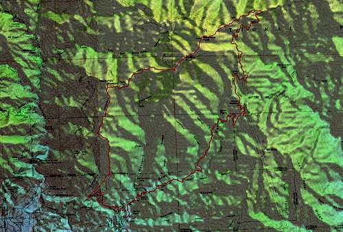
GPS Track of Monrovia Loop
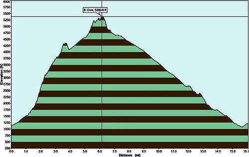
Elevation Profile of Monrovia Loop
Red Tape
You do not need an Adventure Pass for parking at Monrovia Canyon, however if you park within the park you must pay a park entry fee. Also, when parking outside of the park make sure you obey the parking signs (Wednesday is not good due to street sweeping).
External Links
http://www.simpsoncity.com/hiking/monroviapeak.html
http://www.simpsoncity.com/hiking/monrovia.html
http://www.simpsoncity.com/hiking/images/Monrovia_trail_map.gif
http://www.gpsmountaineering.com/monrovia,rankinandclamshellpeaks