
-
 123563 Hits
-
 88.47% Score
-
 27 Votes
|
|
Mountain/Rock |
|---|---|
|
|
32.42440°N / 92.8965°W |
|
|
534 ft / 163 m |
|
|
Overview
When most people think of Louisiana, mountains are the last thing to come to mind and with good reason. This state is one of 3 in the U.S. with its lowest point located below sea level, and its highest point is the 3rd lowest in the country; only Florida's Britton Hill and Delaware's Ebright Azimuth are lower than this 163m (535ft) bump known as Driskill Mountain. The area is very densely forested as is common in the Piney Woods of East Texas and Louisiana. As a result, there have been significant logging operations carried out in the immediate area around this highpoint and so trails can be difficult to follow. The strata of this part of Louisiana contains quite a bit of ferrous sandstone, which creates the reddish tint in the soil of the area. Temperatures rarely drop below freezing in the winter, however, this part of the South usually receives one significant snowstorm in late February or early March each year. |  |  |  |  |
Getting There
From IH-20:- Take Exit 67 S for 1.7 miles to Arcadia
- Go S on SR 147 for 7.4 miles
- Turn SW (R) on SR 797 and continue for 3.7 miles
- Turn W (R) onto SR 507 at T-intersection and continue for 1.0 miles to the Mt Zion Presbyterian Church parking lot
 |  |
Route Information
The primary route on Driskill Mountain begins at the parking lot of the Mt. Zion Presbyterian Church, however, those desiring more vertical gain and more distance can park further south at the intersection where Jot Em Down Rd. comes in. There are two false summits near Driskill's true summit, so the landowners have taken significant steps to help prevent hikers from missing their goal. For additional information, please see the route pages on this site.Red Tape
No permits are required to make the short hike to the top of Driskill Mountain, however, most of the route is on private property. Please be respectful of the owners' wishes and do not take any actions that might jeopardize access to this area.When To Climb
This mountain can be hiked year-round with no ill-effects posed by weather changes. There are slight chances of being deterred by freak ice-storms or hurricanes, but these are well publicized occurrences.History
As Don Holmes states, "Driskill Mountain was named for James Christopher 'Grancer' Driskill (1817-1901), who settled in the farm and timber land surrounding the mountain in the late 1830s after moving from Macon, Georgia. Eventually, Mr. Driskill owned 960 acres in the area. In 1874 he donated two acres of land for what has become the Mount Zion Presbyterian Church and the Driskill Memorial Cemetary. Many of Grancer Driskill's descendants still live near Driskill Mountain."Miscellaneous Info
Driskill Mountain is the highest point of Bienville Parish and is, in fact, the only area in the state where land higher than 500ft can be found. The Mt. Zion Presbyterian Church is located close to the saddle separating Driskill from the only other 500ft summit in Louisiana, Gentry Hill. This 160m (524ft) point only has a 33m (109ft) prominence, but is a nice add-on to a hike up Driskill Mountain.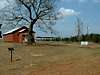 |  |  |  |
External Links
- Driskill Mountain Trip Report - 03/14/2003
- Winter Ascent of Driskill Mountain
Daniel Smith's winter trip report on climbing Driskill Mountain (03/14/2003).
- America's Roof - Driskill Mountain Page
Page dedicated to Driskill Mountain, maintained by the Highpointer's Club.
- Ryan Cragun's site on Driskill Mountain
Very helpful page with maps, photos, information, and a trip report.
- Driskill Mountain Trip Report
Alpinist - Jul 23, 2010 1:56 pm - Voted 10/10
Broken linksFYI - The links at the bottom of the page for America's Roof and Ryan Cragun are no longer in service.
txmountaineer - Jul 26, 2010 5:15 pm - Hasn't voted
Re: Broken linksThanks!