
-
 23526 Hits
-
 88.61% Score
-
 27 Votes
|
|
Mountain/Rock |
|---|---|
|
|
40.79380°N / 110.6821°W |
|
|
12557 ft / 3827 m |
|
|
Overview

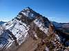
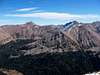
The North Ridge and Summit of Mount Beulah
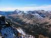
Mount Beulah is a rugged peak in the High Uintas Primitive Area of north-eastern Utah. This mountain is located approximately mid-way along the north-south ridge which divides the left hand fork of the East Fork Bear River (to the west), and the West Fork Blacks Fork (to the east). The peak is located in the Wasatch-Cache National Forest.
A hike to the summit of Mount Beulah is best done as a scenic two or three day backpacking trip. Strong hikers could also make the ascent as a long day hike.
This is a fairly obscure peak which is seldomly visited; the summit register indicated no visitors from July 2003 to October 2004, so solitude is virtually assured on this summit.
With 737 feet of prominence, the peak ranks as #42 on the list of Utah 12,000+ foot peaks with 300+ feet of prominence, as compiled by Scott Patterson.
USGS 1:24,000 Quad:
• Red Knob, Utah
 |  |  |  |  |
Getting There
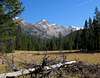
Probably the easiest practical approach to Mount Beulah is by way of the Allsop Lake trail, which begins at the East Fork Bear River Trailhead.To access the trailhead take Utah State Highway 150, heading either south from Evanston, Wyoming, or north from Kamas, Utah. Approximately 0.4 miles south of mile marker 49 a gravel road leaves the highway on the east. From Highway 150 drive 1.8 miles, then turn right at the sign indicating the East Fork Bear River Trailhead. Continue another 4.3 miles beyond the sign to a fork in the road. The right fork enters the East Fork Bear River Boy Scout camp; take the left fork and proceed another 0.5 miles to the trailhead parking area. The trail begins behind the vault toilet at the south end of the parking area.
The dirt road from Highway 150 to the trailhead is well graded and passable by virtually all passenger vehicles when dry.
 |  |  |
Routes
See the 'Routes' section for details on route(s) to ascend the peak.Red Tape
The trailhead is located along the Mirror Lake Scenic Byway. All motor vehicles parked in this area must display a valid recreation pass. These passes may be purchased at numerous self-service locations along Highway 150.Fees are $6.00 per day, $12.00 per week, or $45.00 annually.
When To Climb
The normal summer hiking season in the Uintas runs from July through September, but may vary considerably depending upon the previous season snowpack and the first significant snowfall of the season.Camping
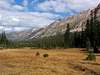
For a multi-day climb of Mount Beulah most hikers will want to set up a backcountry campsite along the Allsop Lake trail. The best situated locations for a campsite would be anywhere near the trail to the west of the peak, approximately two miles to the north of Allsop Lake.Numerous established campgrounds are located along nearby State Highway 150. The campgrounds nearest the trailhead include (from north to south):
• East Fork
• Bear River
• Stillwater
• Hayden Fork
• Beaver View
Mountain Conditions
Links to local weather, road conditions, and fire information can be found on the Wasatch-Cache National Forest website.National Weather Service forecast for the area.