
|
|
Mountain/Rock |
|---|---|
|
|
40.74220°N / 110.35276°W |
|
|
Duchesne |
|
|
Hiking |
|
|
Summer |
|
|
13247 ft / 4038 m |
|
|
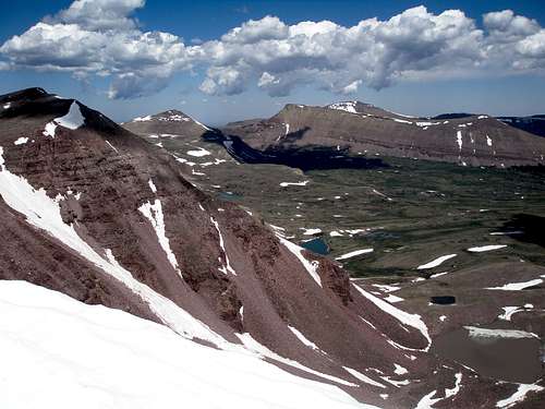
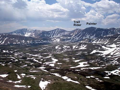
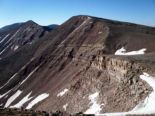
 "Trail Rider Peak" on left
Overview
"Trail Rider Peak", elevation 13247', is the 9th highest peak in the state of Utah, and the 571st highest peak in the contiguous United States. It is located in the middle of the Uinta Range, about 37 miles south of Mountain View, Wyoming and 24 miles north of Mountain Home, Utah and lies 2.6 miles south southeast of the state highpoint, Kings Peak. It is a long hike to the top of "Trail Rider Peak" as the closest trailhead is over 10 miles away. It can be climbed in a day trip but most people should plan for at least 3 days."Trail Rider Peak" is seldom climbed. Only 17 people have recorded an ascent on listsofjohn. As a contrast, 477 people have recorded ascents for Grays Peak, the 9th highest peak of Colorado, as of October 27, 2012. If you want solitude on top of a peak, the Uintas are the place to be. Except for Bald Mountain and Kings Peak, I have never seen another person on top of a summit other than the people I was with.
There are 17 peaks above 13,000 feet in the state, all located in the Uintas, and more than one half of them have no official name, including "Trail Rider Peak". Its east ridge runs down to Trail Rider Pass from which it gets its unofficial name.
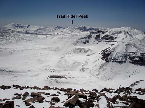
 "Trail Rider Peak" from Trail Rider Pass
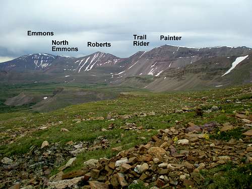
"Trail Rider Peak" has 362' of prominence and is one of seven peaks having over 300' of prominence in the ridge running from Kings Peak to Mount Emmons. When viewed from afar it appears as one in a chain of lofty 13,000 footers.
 "Trail Rider Peak" is left of center
Views from "Trail Rider Peak"
 View north towards Gunsight Pass
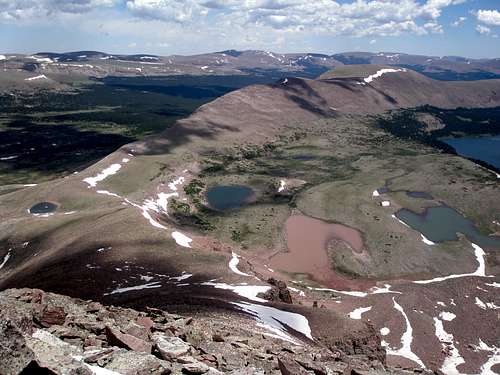 View east towards Val Benchmark
 View southeast of the Kings-Emmons Ridge
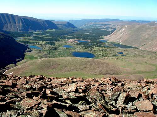 View south of the Timothy Lakes Basin
 View southwest of Timothy Peaks
Getting There
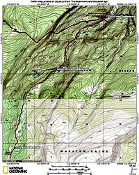
Henrys Fork TrailheadThe trailhead is located south of Mountain View, Wyoming about a 2.5 hour drive from Salt Lake City.
If coming from the west on I80, take exit 34 and head towards Fort Bridger. Pass through Fort Bridger until you reach a 4 way intersection with route 414 with a blinking red light. Turn right/south on route 414.
If coming from the east on I80, take exit 39 and head south towards Mountain View on route 414. Go straight at the blinking red light.
Just south of Mountain View, turn right onto route 410. Follow route 410 for 7 miles until it makes the second sharp right bend where there is a sign for Robertson. At this bend, you go straight onto a very well maintained dirt road. Follow the signs for the Henrys Fork Trailhead which you will reach in about 20 miles.
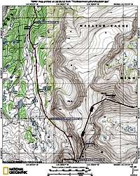
Swift Creek Trailhead
It is just under a 3 hour drive to the trailhead from Salt Lake City.
Find your way to Duchesne Utah. If coming from Salt Lake City, take I80 east to exit 146 (route 40). Head east on route 40 about 76.6 miles to the center of Duchesne. As you pass by Starvation Reservoir, look to your left and you will get a partial view of the 40 mile distant Kings-Emmons Ridge.
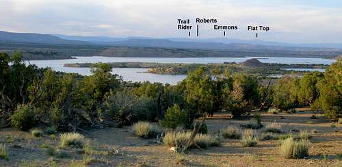 Uinta Mountains viewed over Starvation Reservoir
From Duchesne Utah, turn north on route 87. On this road you will get a view of the entire Kings-Emmons Ridge. Follow route 87 north for about 15.6 miles until just after a hairpin turn where you turn left on 21000 W and head for Mountain Home. Follow this road about 3.6 miles until it ends at a T intersection and turn right.
The road quickly bends left at a 90 degree angle and you again head north to a turn across the Lake Fork River. The road to Moon Lake continues straight, but you turn right onto a dirt road and cross the river heading for the "Yellowstone Recreation Area". This turn is reached just shy of 4.5 miles.
Just shy of .5 miles later take the second of two closely spaced lefts.
4.2 miles later you will come to a left turn for Hells Canyon/Center Park Trailhead. Don't take it.
Continue on the main road another 7 miles where it ends at the Swift Creek Trailhead and campground.
On the way back to Duchesne, the intersection with route 87 is not signed so you have to remember to turn right.
Red Tape
"Trail Rider Peak" lies within the High Uintas Wilderness, whose boundary extends all the way to both the Henrys Fork and Swift Creek trailheads. Thus, normal wilderness area restrictions apply for both trails. In addition, there are usually proximity restrictions for camping near lakes and having campfires. Check the trailhead signboards to find out what the current restrictions are.Camping
There are campgrounds at both the Henrys Fork Trailhead and the Swift Creek Trailhead. There are numerous places to camp along both trails.Henrys Fork
There are three free campsites with picnic tables right before the trailhead parking. On weekdays you can often find one free, but on weekends, they will most likely be occupied.
Swift Creek
There is a fee charged campground right at the Swift Creek Trailhead with 13 campsites. There have always been vacancies every time I've been there.
In addition, if you do not want to pay for camping, there are several turnouts for good dispersed camp sites along the road to the trailhead. These have no facilities. I would recommend that you pick one on the east side of the road, away from the river, as it's roar can be quite deafening.
 Swift Creek Campground
When to Climb
SummerMost years, the beginning of July through the end of September would be suitable for a northern approach. The end of August and the beginning of September are ideal because it is still warm, but the mosquitoes and the crowds in Henrys Fork are both gone.
 End of June
If coming from the south, via the Kings-Emmons ridge, you could go about a month earlier as long as you stick to the ridge. The flat upper basins will still be mired in soggy snow, but the ridge will have large bare spots.
 End of May right after a snowstorm
Winter
On the north side, the access road to the Henrys Fork Trailhead is plowed to 3.5 miles of the summer trailhead. Plowing stops at N40.95255 W110.31484. A spur of about 50 feet towards the campground is cleared out so there is good parking off of the main dirt road. The main road is well plowed as there is a fair amount of traffic during daylight weekday hours as people work just around the corner from the trailhead.
Although I have not personally checked it out, I have heard that the road to the Swift Creek Trailhead is plowed to the turn for a power plant which comes shortly after crossing the Yellowstone River at N40.54644 W110.33331. This is about 4.6 miles from the summer trailhead. If anyone has a first hand report regarding winter parking and travel in this area I would appreciate it if they would pass it on to me.
A winter trek across the Kings-Emmons ridge would be awkward. The main impediment would be wind which can be strong enough that it is hard to stand. Much of the snow is blown off of the ridge leaving huge swaths of exposed rocks. Skiing it would be impractical and snowshoeing not much better. If booting, the snow between the rocks may be quite deep making progress slow.
 Beginning of April
Routes
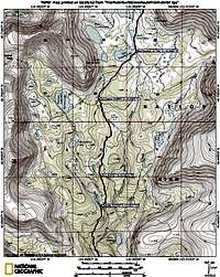
Of all the peaks between Kings Peak and Mount Emmons, Trail Rider Peak is the most easy to climb directly, but it is still a lot of work to get there. As the crow flies it is 11.55 miles to the Henrys Fork Trailhead to the north and 9.7 miles to the Swift River Trailhead to the south. The southern route involves either 2 difficult stream crossings or a 1 mile not too pleasant bushwhack. The northern approach is longer, but the trail has a lot better footing than the southern trail which is littered with fist sized or bigger loose rocks in sandy dirt.Henrys Fork direct
Take the Henrys Fork Trail to Gunsight Pass, descend the other side into Painter Basin, make your way to Trail Rider Pass at the base of the peak, and then ascend the ridge running from the pass to the summit. This would be about x miles round trip with a round trip elevation gain of x. 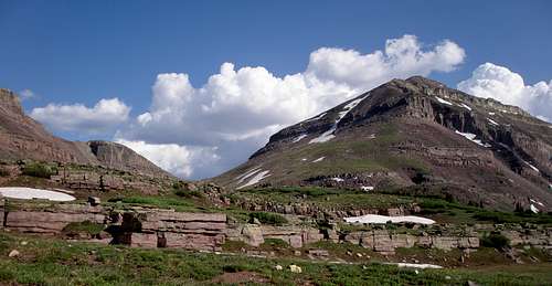 Heading to Gunsight Pass Heading to Gunsight Pass
|

Swift Creek direct
Take the Swift Creek Trail 9.15 miles to the east end of East Timothy Lake. Make your way 2.06 miles cross country to the saddle between Trail Rider Peak and Roberts Peak, staying to the east of Lower Carrot Lake and minor point 12066. Ascend Trail Rider's southeast ridge .33 miles to the summit. The trail is well maintained and easy to follow but has 2 difficult stream crossings. They can be avoided by doing a 1 mile not too pleasant bushwhack as shown on the map.  Trail Rider-Roberts saddle from East Timothy Lake Trail Rider-Roberts saddle from East Timothy Lake
|


North Kings Emmons Ridge
Since Trail Rider Peak is merely one of several peaks strung close together along the Kings-Emmons Ridge, most people will want to climb a few of them on the same trip. The easiest way to climb the 4 northermost peaks of the ridge is to take the standard Henrys Fork route to Kings Peak, follow the ridge south attaining South Kings, Painter Peak, and Trail Rider Peak, descend Trail Rider's north northeast ridge to Trail Rider Pass, make your way across Painter Basin to Gunsight Pass, and then take the Henrys Fork Trail back to the start. Details can be found in The Northern 4 Peaks route page.
 Heading south to "Trail Rider Peak" on the Kings Emmons Ridge
Mountain Weather
Most trips to "Trail Rider Peak" will involve being above treeline in the afternoon. Therefore, you need to be particularly cautious with thunderstorms which are predicted virtually every summer day.Here is a link to the current 7 day forecast for "Trail Rider Peak".
 Bad weather brewing above Trail Rider Peak
External Links
Evanston-Mountain View Ranger DistrictAshley National Forest