
|
|
Mountain/Rock |
|---|---|
|
|
40.76168°N / 110.4735°W |
|
|
Duchesne |
|
|
Hiking |
|
|
Summer |
|
|
12892 ft / 3929 m |
|
|
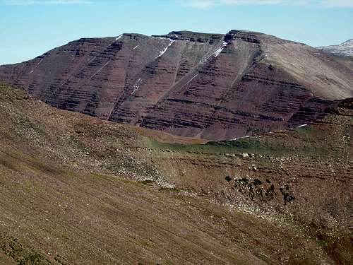
 The northwest face of Porcupine Mountain
Overview
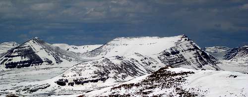
At 12892 feet, Porcupine Mountain with prominence of 656 feet ranks 22nd on Scott's list of Utah 12,000+ Foot Peaks with 200+ Feet Prominence. Porcupine Mountain sits due south of Porcupine Pass (12236) which is one of the high passes reached via the Highline Trail which runs in a generally east/west direction through the Uinta Mountains of Utah. It is only 656 feet up from the pass to the summit of the peak. On the other side of the pass sits Wilson Peak (13060), Utah's 17th highest peak. Kings Peak, Utah's highpoint lies 5.37 miles to the ENE. Porcupine Mountain is one of seven peaks over 12000 feet that ring Garfield Basin. South Porcupine and Porcupine Mountains
From the summit one can see Wilson to the NE, the three summits of Mount Powell through the Wilson/East Wilson saddle, and Kings and South Kings to the ENE. Squaw Benchmark is to the NW, Oweep Peak (12531) is to the W, and South Porcupine Mountain is to the SW.
 Mount Powell
There are no short routes to the summit. It is about 31 miles round trip from the Center Park Trailhead to the south. Most people would not want to climb this peak by itself but would do it as part of a multiday trip to several summits. The best months to climb are July, August, and September.
 Porcupine, Wilson, E Wilson ridge
Getting There
Access from the south is via the Center Park Trailhead.Red Tape
Group size is limited as per wilderness area rules. Many lakes have proximity restrictions. These restrictions change from time to time so check the sign board at the trailhead to see what restrictions are currently in place.Camping
 S ridge of Porcupine Mt
There are 5 established campgrounds near the Center Park Trailhead as descriped in the trailhead page. There are numerous places to camp in Garfield Basin.
Routes
From Porcupine Pass 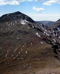 The north ridge of Porcupine Mountain The north ridge of Porcupine MountainThe easiest way to climb this peak would be as a detour from a Highline Trail backpacking trip. When you get to Porcupine Pass travel south up Porcupine Mountain's north ridge. It is a simple class 2 boulder hop of 656 feet to the top. |
From Center Park on the south 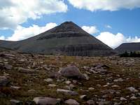 Porcupine from the SE Porcupine from the SE Looking west across Garfield Basin at Porcupine Looking west across Garfield Basin at Porcupine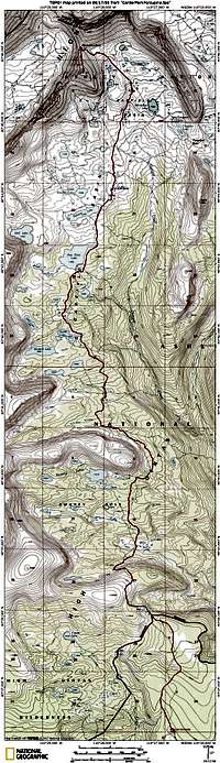 Topo map of Center Park route Topo map of Center Park routeStart at the Center Park Trailhead and head north on the trail to Garfield Basin. After about 12 miles, leave the trail at N40 44.051 W110 27.856 and head north cross country until you intersect the Highline Trail in about 2 miles. Turn left/northwest on the Highline Trail and follow it to Porcupine Pass. From the pass turn south and climb the ridge to the summit. Alternatively, you could take the Garfield Basin Trail all the way to the Highline Trail to just southwest of Tungsten Lake and then turn left/northwest on the Highline Trail. This would add another 1-2 miles each way. Mostly following the trail but going cross country in Upper Garfield Basin as shown on the map it is 31 miles round trip with 4075 feet of elevation gain on the way in and 1601 feet of gain on the way out. But, why go all that distance for just one peak. All seven of the peaks above 12000 feet ringing Garfield Basin can be done in one trip and if you're going to get one you might just as well get them all. See Garfield Basin Rim Loop. |