
-
 6938 Hits
-
 84.82% Score
-
 19 Votes
|
|
Mountain/Rock |
|---|---|
|
|
36.23609°N / 114.50022°W |
|
|
Clark |
|
|
Hiking, Scrambling |
|
|
Spring, Summer, Fall, Winter |
|
|
3349 ft / 1021 m |
|
|
Overview
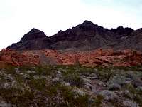
East Redstone Peak, locally named, is one of many sacred peaks in the Lake Mead NRA. This peak can be hiked along with many in the area, including Redstone Peak. In fact you will get the most enjoyment by hiking and scrambling this peak along with Redstone Peak. To the NE of Redstone Peak is another locally named peak, known as Tall Cairn Peak.Also, if there is time and daylight after you bag all the peaks in the area you choose, it would be worthwhile to hike and scramble around the red and orange sandstone along the Redstone Trail.
Getting There
Driving around Las Vegas drive to exit 45B on I-15 and go east. Drive East about 4 miles to the intersection of Lake Mead Blvd and Nellis Blvd. Set your odometer to 0.Continue East on Lake Mead Blvd. Follow the main road all the way around the curves once over the mountain pass. At 10.6 miles you will reach the fee booth. Once past the fee booth you'll drive another 2.1 miles (12.7 total) to a T-Intersection. Turn Left. Drive another 23 miles just past mile marker 27. You will see the Redstone Trail parking area on the right. Park here.
 Northshore Peak seen on the drive to Redstone.
Red Tape
Daily passes are $5 (good for 1-5 days; per vehicle).Yearly ones for $20 which are good through December 31st in the calendar year purchased. (Per vehicle)
Individual 1-5 days $3.00 per person (motorcycle, bicycles, hikers)
Individual Calender Year $20.00 per annual pass (motorcycle, bicycles etc.)
For More Information Call (702) 293-8907. Fees & Reservations
Camping
Car camping inside Lake Mead NRA is permitted only in front-country campgrounds and designated campsites. However, BLM land borders much of the park, and camping on BLM land is open and free. Though, you should choose an existing site and practice Leave-No-Trace skills.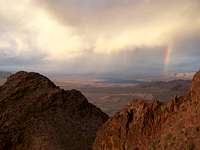
The Hike
 GPS Trace of Redstone and East Redstone Peaks.
There are several options here. You can hike up to Redstone Peak and then down the ridge to the saddle and up East Redstone Peak, or you can hike southeast towards East Redstone and go up the gully and get East Redstone out of the way.
The best way I suggest would be to hike up to Redstone Peak and then take the ridge over to East Redstone.
From the parking area start hiking south, southeast along the Redstone trail. In the foreground you can see Pt. 950. Continue along the Redstone Trail. You will have to scramble over the sandstone almost ½ mile into the hike. Once you’ve scrambled on the other side of the sandstone contour around on the NE side of Pt. 950. Once on the East side of 950 you will see Redstone Peak straight ahead of you to the Southeast. You have a choice to head straight ahead up the steep ridge and up the gulley or to turn to the right (south) and head up to the Saddle and hike up the west ridge to the summit.
Now that you are on Redstone Peak enjoy the views from here before moving on. Once you are ready to move on you can now head easterly along the ridge and down to the saddle and then up East Redstone Peak. From here you can hike onto other unnamed peaks in the area or hike down to the saddle and scramble and hike down back towards the Redstone Trail and the parking area.

 routes up Redstone