
-
 16149 Hits
-
 84.82% Score
-
 19 Votes
|
|
Mountain/Rock |
|---|---|
|
|
34.24890°N / 118.1146°W |
|
|
Los Angeles |
|
|
Hiking |
|
|
Spring, Summer, Fall, Winter |
|
|
5796 ft / 1767 m |
|
|
Overview
A close neighbor of Mt. Disappointment, Mt. Deception’s name is equally intriguing. However, unlike the former, no one is certain of the origin of Mt. Deception’s name. Nor will you find the name on any map. The Mt. Wilson 7.5 quadrangle merely shows a marking at 5,796 feet elevation east and a little north of Mt. Disappointment. That’s it. Nevertheless, it’s a fine little peak with a short, but steep ridge ascent from the Mt. Disappointment Fire Road.The direct routes to Mt. Deception are from the Mt. Disappointment Fire Road trailhead(4,760’). There are some nice views to be had of other parts of the San Gabriel range from this fire road.
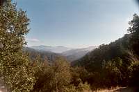 Another view east from Mt. Disappointment Fire Road
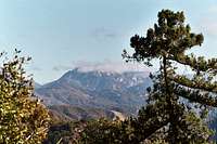 View east from Mt. Disappointment Fire Road
Go up the paved fire road about 2 miles to a large saddle at 5,550 feet elevation and then go right onto a firebreak on Mt. Deception’s east ridge.
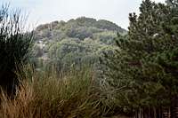 Firebreak route (left of center)up east ridge of Mt. Deception
Probably a more enjoyable route from the same trailhead is to take the San Gabriel Peak Trail. The trail is shaded and well-maintained. 1.3 miles from the start, the trail intersects the Mt. Disappointment Fire Road about two hundred yards below the big saddle between Mt. Disappointment and San Gabriel Peak (5,800’). When you get to the fire road, take a right going downhill. In about 0.6 miles, you will arrive at the saddle at 5,550 feet elevation mentioned above. Now go left onto Mt. Deception’s east ridge and to the summit. The round trip mileage for this route is about 4.4 miles.
If you are coming from the direction of Eaton Saddle, when you get to the saddle/trail junction between San Gabriel Peak and Mt. Disappointment, take the Mt. Disappointment Fire Road down a little over ½ mile to the beginning of Mt. Deception’s east ridge.
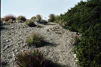
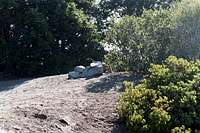 Summit of Mt. Deception
At the summit, take in the views south and west of beautiful Bear Canyon. Because of the tree cover on the summit, to get the views easterly of Mt. Deception’s neighbors, you will have to back track a little down the ridge.
 Down the ridge from near the summit
 Mt. Markham (L), Mt. Lowe (R) from east ridge of Mt. Deception
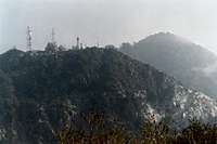 Mt. Disappointment (L), San Gabriel Pk (R) from east ridge of Mt. Deception
 Double image of peaklet near Mt. Disappointment
Getting There
From the 210 Freeway, exit at Angeles Crest Hwy (SR 2) and go north. At 9.5 miles, you will come to the Clear Creek Ranger Station and the junction with Angeles Forest Highway. Continue straight on SR 2 about 4.5 miles to the junction with the Mount Wilson Road at the Red Box Ranger Station. Turn right. Drive 0.4 miles and look for the turnoff on your right into the trailhead. There is a small parking area next to the white fire road gate. Walk past the gate and you are on the Mt. Disappointment Fire Road. To get to the San Gabriel Peak Trail, go about 50 yards in the opposite direction from the fire road gate and you will see the beginning of the trail at the base of the slope. Beginning of San Gabriel Peak Trail
Red Tape
You will need an Adventure Pass to park your vehicle anywhere within the Angeles National Forest. These passes are not sold at most trailheads. However, they are currently sold at the Red Box Ranger Station (thus on the way to the Mt. Disappointment Fire Road trailhead ($5 per day or $30 for a yearly pass). Otherwise, they are sold at most sporting good stores.No permits are required for hiking.