
-
 4286 Hits
-
 77.48% Score
-
 8 Votes
|
|
Mountain/Rock |
|---|---|
|
|
32.74920°N / 17.05325°W |
|
|
Hiking |
|
|
Spring, Summer, Fall, Winter |
|
|
5315 ft / 1620 m |
|
|
Overview
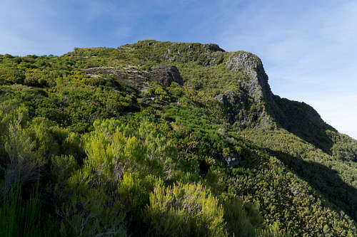 Pico Bica da Cana seen from the south
Madeira is a deeply divided island. Unlike Cyprus, however, the division is not political but rather geographic: while to the east of Boca da Encumeada you will find one of the wildest volcanic mountain ranges on earth with summits up to nearly 2000m, to the west of the pass there is the huge, slightly sloped high plateau Paul da Serra. The plateau is one huge, windswept bog thanks to Madeira's generous precipitation. And while the island is very busy almost everywhere, Paul da Serra is a notable exception. The centre of the plateau is as lonesome as it gets and even on the outskirts fierce winds and frequent fog and rain keep visitors to a minimum.
To the north and east Paul da Serra shares some of the wildness of Madeira's central range with huge and deep near vertical faces, to the south and west, however, it more gradually lowers to the coast. Out of this plateu, two summits rise some 3km apart from each other: Pico Ruivo do Paul, at 1640m, Paul da Serra's highpoint and Pico Bica da Cana, at 1620m only a little lower than its neighbour. Both rise above their respective north and east faces so that they become massive undertakings from one of the lower trailheads while reachable by a short stroll from their respective parking lots on the high plateau.
 |
 |
 |
ER105, the road across Paul da Serra, passes close by Pico Bica da Cana and a small parking lot invites visitors to the mountain. Thanks to its location on the eastern edge of the plateau and high above the Sao Vicente Basin, it is a wonderful lookout towards madeira’s central mountain range in the east. A drop of more than 1000m separates it from the basin floor. Also, it is a good place to watch the trade wind clouds ooze across Boca da Encumeada and the weather divide.
As mentioned before Paul da Serra catches a lot of rain so that the plateau is a giant bog, where multiple sources spring. Beneath Bica da Cana’s east face there is a giant ledge onto which a multitude of waterfalls drop. Their water is collected in a irrigation channel, Levada Loumba do Mouro, which runs across the ledge. Also one of the routes onto the mountain follows the ledge beneath and sometimes directly through the waterfalls.
 |
 |
 |
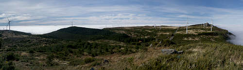
A winding path runs from Pico Bica da Cana towards the north to its slightly higher neighbor, Pico Ruivo do Paul. It runs along the edge of the Paul da Serra Plateau, winding through the (admittedly ugly) windmills but offering great views across the Sao Vicente Basin. It thus connects the two highest summits of the Paul da Serra high plateau in a 2h hiking loop.
Summit Panorama
  |
Getting There
 Paul da Serra Plateau with the access road visible in the centre
Madeira can be reached from any of the major European airports. There are almost no regular flights (with the exception of some portugese airports) but quite a lot of charter flights.
The closest trailhead to Pico Ruivo do Paul is only a few hundred metres to its south on the plateau Paul da Serra. Other options are Boca da Encumeada, a parking lot near Pico Bica da Cana, Paul da Serra's second highest summit or the town Sao Vicente on Madeira's north coast. All trailheads are close to each other and can be reached very similarily.
- Take Motorway R101 until its end at Ribeira Brava.
- After the long last tunnel don't turn to Ribeira Brava but to Serra de Água (ER104).
- Go left at the start of Serra de Água turn left and go up to Boca da Encumeada on ER105.
- Pass the lookout in the pass and drive up ER105 through multiple tunnels.
- After about 1km there is a small parking lot on the left hand side. Here you can start on a route leading through the Paul da Serra west face on Levada do Lombo do Mouro.
- If you stay on ER105 until you reach the plateau you'll find the parking lot near Pico Bica da Cana on the right hand side.
- After two turns in the road you'll reach the intersection with ER209. Turn left (south) and drive until you reach the edge of the plateau.
- After two switchbacks you’ll reach a forestry station, where you can park. Levada do Paul crosses a few hundred metres down the road. Start on the left hand side.
Routes
Reasonably there are two decent routes to Pico Bica da Cana even though you can reach the summit from a parking lot right beside ER105 in 20 minutes.
Levada do Lombo do Mouro
You start from the small parking lot on ER105 to the south of the Paul da Serra rock faces. Here Levada do Lombo do Mouro crosses the road and you can follow it upstream. There are lots of waterfalls filling the levada, a sign for the remainder of the hike. After a few hundred metres the path turns and runs in switchbacks up to a broad ledge, where it regains the levada. Staying on the ledge you finally reach a steep and narrow gully, which heads up on the south side of Pico Bica da Cana, passing the summit. Two trails lead to the top, one directly from the west, the other a disused road reaches it from the north.
As an Alternative you can stay on the ledge, passing Pico Bica da Cana by a long way. The path ends on a dirt road which comes up all the way from Sao Vicente and heads in the direction of Pico Ruivo do Paul. Either climb that mountain first or turn south onto a path which heads along the edge of the plateau Paul da Serra. There are wonderful views even though you have to wind between the rather ugly windmills on top of the plateau.
Levada Bica da Cana
 |
 |
 |
Starting near the forestry station on ER209 follow Levada do Paul to the east. It heads up to a shoulder then descends in direction of the Cascalho Cauldron. Long before it reaches the cauldron a road crosses and Levada Bica da Cana joins. Climb up a levada staircase, then stay with the levada until you reach the upper end of Cascalho (a nice waterfal can be found in a nook there). A few hundred metres beyond a path heads onto Paul da Serra, still following the (now tiny) Levada Bica da Cana. Stay with the levada, which springs right beneath the west slopes of Bica da Cana. Follow the disused road to the top.
Red Tape
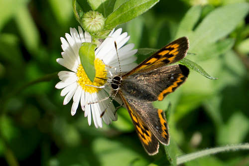 Lycaena phlaeas, the small copper
There's no red tape here. However, parking space at the two trailheads is very limited and there is no option to park on ER105 directly. Also, take extreme care with fire. There has been a series of forest fires in the last years which destroyed much of Madeira's wonderful vegetation, especially on the south side of the weather divide.
Accommodation
You can find a lot of hotel rooms and apartments on Madeira. Either, visit the next travel office or do an internet search. The island is small, all trailheads can be reached by car in an hour from almost anywhere on the island. Most accomodation can be found in the south of the island near Funchal and Camara de Lobos.
Weather Conditions
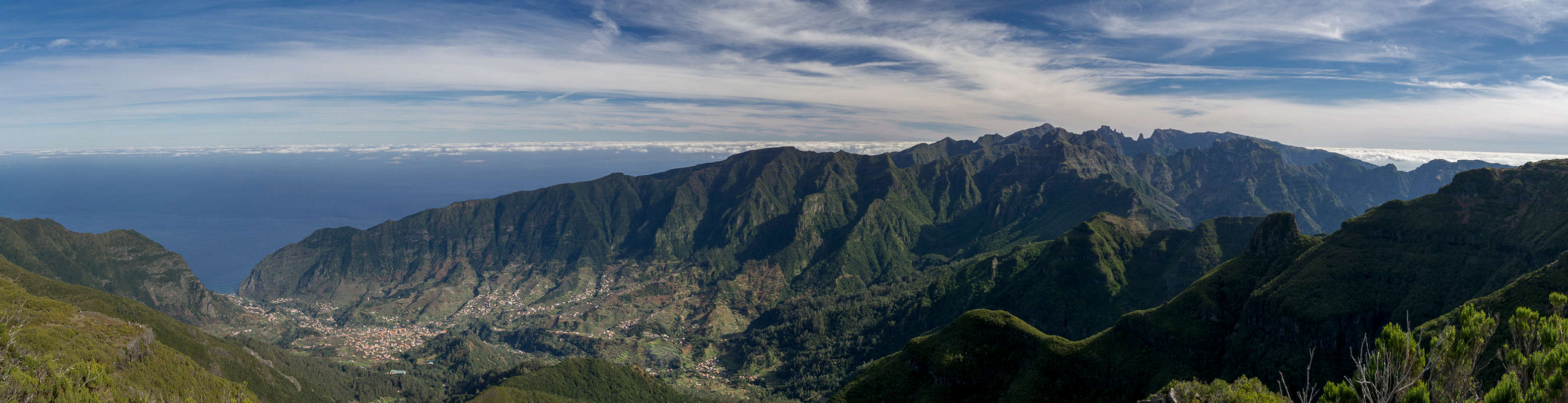
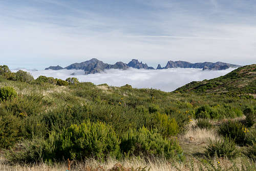 Madeira's central range seen while descending Pico Bica da Cana
Weather conditions cannot be predicted accurately. Madeira is located in the trade wind zone. You almost always encounter northeastern winds which carry a lot of humid air. Being forced to climb to higher altitudes this moisture condenses into clouds. This in return means that most of the time the northern part of the island is covered in clouds from altitudes of 1000m through 2000m.
The mountains themselves - being of the same altitude -finally stop the clouds so that on their southeastern slopes the clouds "run out". Look at the pictures - it looks like the clouds creeping over the weather divide. Boca da Encumeada - being some 500m lower than the surrounding summits - is a gateway for the clouds from north to south. Thus it very often is covered in mist. Unfortunately all of the major peaks of Madeira lie around the weather divide, sometimes within, sometimes just out of the clouds.
Paul da Serra, in particular, is famous for ist quickly rising fogs. A nice day can turn into a whiteout in less than half an hour.
The following table shows weather data for Funchal on the southern coast. Be careful with these data if you want to climb the summits...
| Month | Jan | Feb | Mar | Apr | May | Jun | Jul | Aug | Sep | Oct | Nov | Dec |
| Avg. day temp.[°C / °F] | 16 / 61 | 16 / 61 | 17 / 63 | 20 / 68 | 24 / 75 | 27 / 81 | 29 / 84 | 29 / 84 | 27 / 81 | 23 / 73 | 21 / 70 | 17 / 63 |
| Avg. night temp.[°C / °F] | 9 / 48 | 9 / 48 | 10 / 50 | 12 / 54 | 15 / 59 | 19 / 66 | 21 / 70 | 22 / 72 | 19 / 66 | 16 / 61 | 13 / 55 | 11 / 52 |
| Water temp.[°C / °F] | 16 / 61 | 15 / 59 | 16 / 61 | 16 / 61 | 19 / 66 | 22 / 72 | 24 / 75 | 25 / 77 | 24 / 75 | 23 / 73 | 20 / 68 | 17 / 63 |
| Rainy days | 12 | 7 | 8 | 4 | 2 | 1 | 0 | 0 | 2 | 6 | 6 | 10 |
Maps & Books
Maps & Books
Maps
- Madeira
Tour & Trail Map
Discovery Walking Guides
1:40000
ISBN: 190494678X
Books
My recommendation is a guidebook by Rother Verlag, available in several languages. The book is an excellent hiking guide covering all the interesting areas of the island. Since it comes with small maps for each excursion it might even be used without a map to support them.
- Madeira
Rolf Götz
Rother Verlag
ISBN 978-3-7633-4811-4 (English)
ISBN 978-3-7633-4274-7 (German)
ISBN 978-3-7633-4910-4 (French)
ISBN 978-3-7633-4297-6 (Portugese)
ISBN 978-3-7633-4708-7 (Spanish)