
-
 15782 Hits
-
 93.31% Score
-
 42 Votes
|
|
Mountain/Rock |
|---|---|
|
|
47.42350°N / 10.31496°E |
|
|
Hiking, Trad Climbing, Via Ferrata |
|
|
Spring, Summer, Fall |
|
|
6421 ft / 1957 m |
|
|
Overview
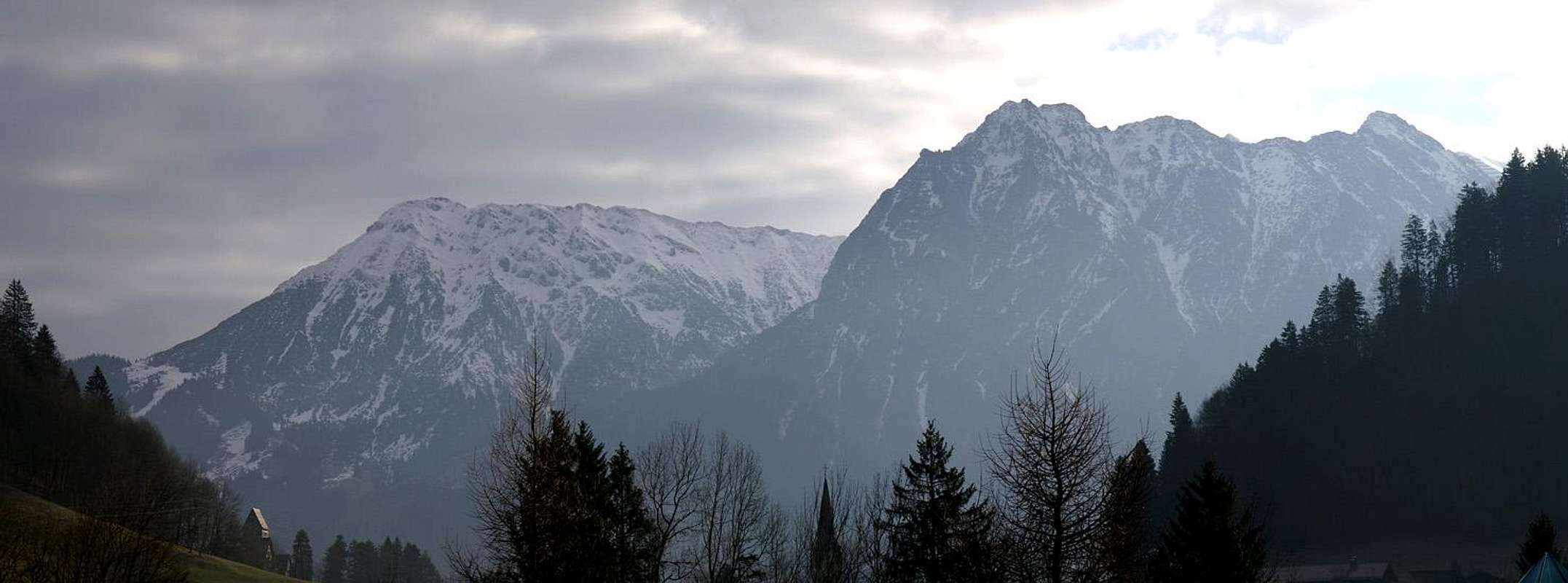
 Rubihorn and Gaisalphorn above the Schattenbergschanze ski jumping complex Rubihorn and Gaisalphorn above the Schattenbergschanze ski jumping complex |
Rubihorn is arguably the last (or first depending on your viewpoint) "real" mountain of the Allgäu Alps. It is the westernmost bastion of the Daumen - Nebelhorn ridge and towers roughly 1000m above the village of Rubi in the Iller Valley underneath. The mountain is a near 2000er, made of grey main dolomite rock which is more brittle than the yellow-whitish Schlern dolomite which you find in the Dolomite mountain ranges in northern Italy. Rubihorn displays steep east, north and west faces, which drop down into the valley underneath. It is connected by a sharp knife-edged ridge with neighbouring Gaisalphorn, which is only one four meters lower. The ridge can be traversed by a protected trail (gesicherter Steig) which is one of the most interesting hiking routes in the Allgäu Alps. Thanks to the exposed position of both mountains the ridge offers perfect views into the Allgäu Alps and the surrounding mountain groups of the area. Rubihorn has two summits, the main summit at 1957m and the northern summit at 1952m.
The regular routes to the summit of Rubihorn are far less difficult, rather regular hiking trails, which get rather steep near the summit. The south-western route from Oberstdorf traverses the forest at the base of the mountain before endlessly zig-zagging towards the Rubihorn-Gaisalphorn ridge, which it reaches close to the Rubihorn summit. The north-eastern route follows the Gaisalp Valley, where it passes by two beautiful mountain lakes. The final ascent is a steep scree scramble along well-trodden paths. Rubihorn - thanks to its exposed location is a popular summit so that you can expect lots of hikers at every time of the day on both of its routes and on the summit. It definitely pays to start early.
 |  |  |
The Rubihorn north face also is a popular climbing destination, especially in winter. There is a couple of ice falls of 180m and 60m height (rated WI3 and WI2-3 resp.) across which some of te routes lead. The face itself is crossed by numerous ledges which keep the difficulties down between UIAA 2 and 3 but which also accumulate large amounts of snow to be dug through. In the next section I have added several (German) links dealing with the Rubihorn north face.
The Rubihorn North Face (Climbing route links)
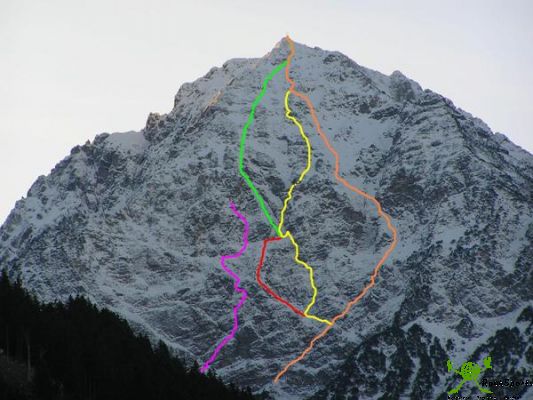  Rubihorn north face with routes as described on rocksports.de |
All links are in German.
- www.lotharklingel.de - excellent winter climbing shots
- bergsteigen.at - detailed route description
- rocksports.de (1) - Rubihorn NW with route overview pictures
- rocksports.de (2) - Forum discussion of the Carpe Diem Route with topo
Getting There
EntschenkopfRubihornGaisalphornNebelhornZeigerHüttenkopfSeeköpfelSchattenbergSchneckGroßer /Hinterer Wilder 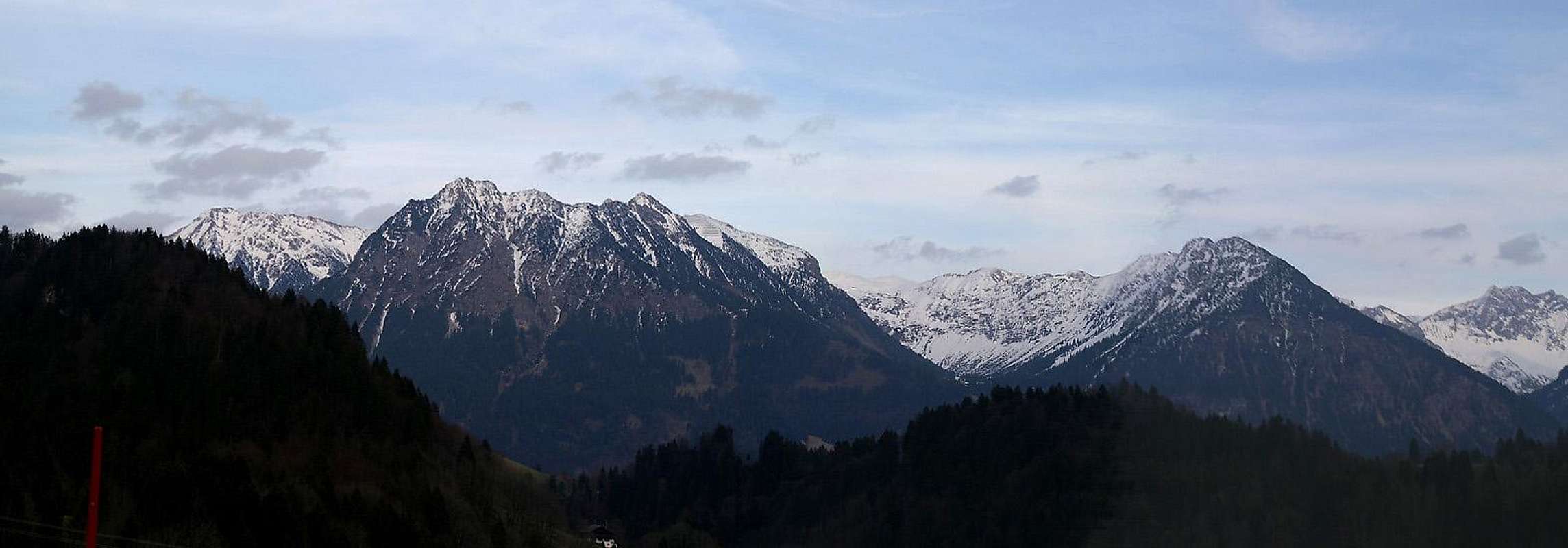 |
The two main routes to Rubihorn start at the town of Oberstdorf and at the village of Reichenbach to the north-west of the town. Oberstdorf is located in a dead end valley in the midst of the Allgäu Alps. The closest airports are at Munich and Stuttgart, cities which are connected by motorway A8. Quite central between the two cities there is the intersection "Ulm-Elchingen" from where motorway A7 leads southward in direction of the Allgäu Alps. South of Kempten take A980 west, which ends after a couple of miles/kms where you have to switch to B19 south. This highway takes you all the way to Oberstdorf. For the Oberstdorf trailhead start at the Nebelhornbahn cable-car. For the Reichenbach trailhead you have to switch to OA4 right before you enter Obersttdorf and drive north-eastward for a few km.
Red Tape
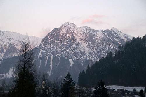 Rubihorn and Gaisalphorn in the Alpenglow
The whole Daumen Group, to which Rubihorn belongs, is part of the natural preserve "Naturschutzgebiet Allgäuer Hochalpen". The usual rules apply - don't disturb wild animals, don't collect any plants, stay on the marked trails. Dogs should be kept on leash. These rules seem to be rather outdated when you see the brouhaha around the Nebelhorn cable-car stations. But remember, that parts of the group still are remote and can be solitary.
Parking lots: you have to pay for almost all parking lots in Oberstdorf. There is a large unguarded one to the south of the cable-car which is (still) free of charge. The Nebelhornbahn cable-car is very expensive.
Accommodation
 |
You can choose between campgrounds, farm holidays, vacation homes and hotel rooms on most of the sites of the Allgäu villages. A good starting point for your search is:
Weather Conditions
All of the towns and villages of Allgäu have their web sites, most of them with weather information and live cams. Here is a small selection
Maps & Books
Maps- Allgäuer Alpen / Kleinwalsertal
1:50000
Kompass Map WK 3
Kompass Verlag
ISBN: 3-85491-005-3
- Alpenvereinskarten : Allgäu-West
1:25000
Deutscher Alpenverein
ISBN: 3928777130
Books
- Allgäuer Alpen und Ammergauer Alpen Alpin
D. Seibert
Alpenvereinsführer
Rother Verlag
ISBN: 3-7633-1126-2
- Allgäu 1 - Oberallgäu und Kleinwalsertal
D. Seibert
Rother Verlag
ISBN: 3-7633-4289-3