
-
 6540 Hits
-
 84.27% Score
-
 18 Votes
|
|
Mountain/Rock |
|---|---|
|
|
46.33136°N / 12.26444°E |
|
|
Dolomiti di Zoldo |
|
|
Mountaineering, Trad Climbing, Sport Climbing |
|
|
Spring, Summer, Fall |
|
|
7972 ft / 2430 m |
|
|
Overview
Sasso di Toanella 2430 m
What's New on this Page?
* Jul 28, 2017 - Ownership switched by andrea
* Jul 31, 2017 - Page under review
* Dec 11, 2019 - Overhaul
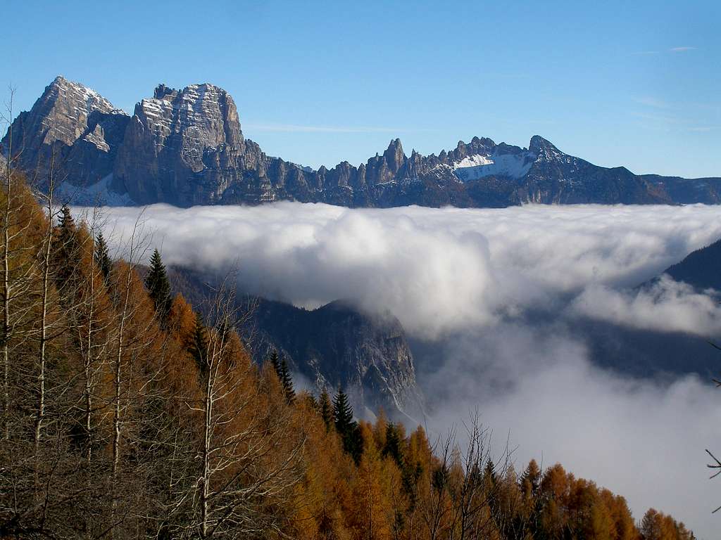
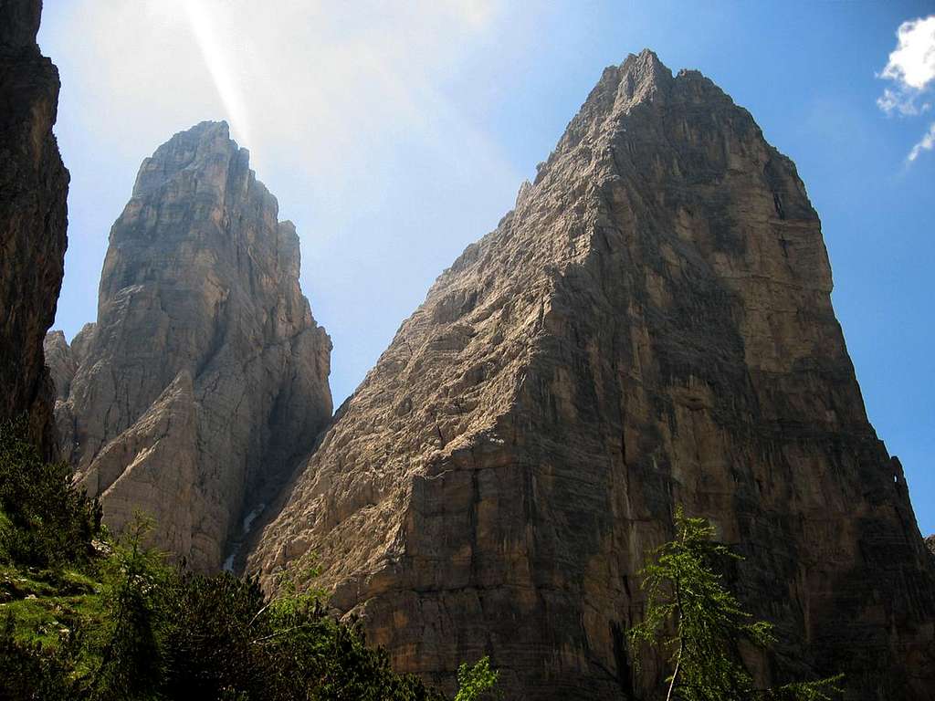
Sasso di Toanella 2430 m is one of the finest peak of the Bosconero group and the second in height. It is hidden between Sasso di Bosconero and Rocchetta Alta di Bosconero. For people who goes up to the “Forcella Toanella”, it appears suddenly as a huge tower with a typical dolomite shape.
The walls are vertical on all sides, and only the homonymous notch permit an higher access to the walls. From here start its normal route that goes up through the few smooth rocky passages on the east side. Otherwise the peak could be visible towering among the neighbour peaks, only from far or from south.
Sasso di Toanella attracted many explorers in the past and also many climbers, due to its fascinating appearance. The quality of the rock is also very good in every part. The summit was climbed for the first time in the july 21st 1893, from the dutch lady Jeanne Immink, with the guides Sepp Innerkofler and Pietro Dimai. Thinking it was unnamed, she gave to the peak the name “Campanile Innerkofler” dedicated to her young guide. Only during the 1912, after the second ascent, Antonio Berti gave it the original and local name “Sasso di Toanella”.

|

|
The structure of the mountain extends towards Southeast with some spires. The are called: “Diti di Toanella”, “Castelletto di Toanella” 2251m and “Croda della Spionèra” 2200m. The climbing routes are numerous, and among the finest we have: the Route of the ledge on the West wall, the North wall and along the east cleft.

|

|
Getting There
The group is located inside the “Dolomiti di Zoldo” region. For people coming from “Po Valley”, the fastest way to approach is reachung the village of "Longarone". Not far from the city of "Belluno". Another way to approach is reaching Zoldo: from "Feltre" or "Belluno": road n.203 – Agordo – Passo Duran – Zoldo.
Sasso di Toanella is located in the South side of the group. It overhangs the "valle di Tovanella". But from this side starting from the village of "Termine di Cadore" the approach would be very long and unconfortable (2000 meters drop!). The best choice is come up from the valley of Zoldo and have a break at the Refuge Bosconero.

From Turin or Milan or Venice: motorway A4 - Mestre - motorway A27.
- By plane The nearest international airports are "Treviso", used for many low-cost flights, and "Venice" "Marco Polo".
- By train The nearest railway station is Longarone; Belluno station can also be used as the DolomitiBus service leaves from there for Longarone/Pecol.
- By bus Various buses of the DolomitiBus service leave from the Belluno bus station (opposite the railway station) and reach Val Zoldana in approx. 1hour.
The routes

|

|
Yellow line: The East cleft route - Green line: "Via del Camino Alto" - Red line: The North wall - Blue line: "Via degli Scoiattoli"
From East: (via originaria) – J. Immink/S.Innerkofler/P.Dimai – 21/07/1893 – 270m – II°/III°
From South-East: (Normal route) – M.G.Carugati/A.Berti/L.Tarra/O.Nicoli – 10/07/1912 – 350m - I°/II°
From “forcella di Rocchetta Alta”: V.Angelini/S.Sperti – 26/08/1923 – 250m - II°/III°
From West side: S.Sperti/V.Angelini – 23/07/1925 – nice itinerary on ledges - 450m – IV
From West side: (via diretta) – C.Pinelli/G.del Campo – 25/07/1964 – very fine route in wild environment – 400m – V A1
North-West pillar: (via degli Scoiattoli) – L.de Pozzo/D.Valleferro/S.Lorenzi/S.Pompanin – 01/07/1968 – the hardest route - 400m – VI/VI+
North wall: G.Da Damos/P.Sommavilla – 16/08/1964 – probably the finest, very good rock – 400m – IV/V passages of VI
East cleft: G.Da Damos/G.Gianeselli/P.Sommavilla – 30/08/1964 – very fine route, very good rock – 250m – IV/V
From East: (via del Camino Alto) – G.Pierazzo/V.Pasqualetto/C.Calamelli/G.Jannuzzi/V.Cicchiello – 07/08/1966 – 250m – IV/V
From South-East: (via a Spirale) – P.Sommavilla/T.Sovilla – 18/07/1982 – 300m – IV+
South-East pillar: T.Sovilla/P.Sommavilla/I.Ducapa – 21/08/1981 – 200m – V+ A1
South-East couloirs: T.Sovilla/P.Sommavilla/C.Angelini/I.Ducapa – 20/08/1981 – 200m – IV

Red Tape
No permits, no fees and no particulary restrictions in hiking and climbing, but the whole area had been acknowledged inside the Unesco World Heritage natural sites list and requires the best care and respect.
More info about Dolomites Unesco Heritage on SP in this article by Silvia Mazzani: Dolomites, living mountains.
Huts

Open from: 20/06 - 20/09
Phone: +393383713870
Keeper: Monica Bagatin tel. +393383713870
Property: CAI sez. Valzoldana tel. +39 0437 78100
Places: 28 winter 4
Access: From lake of Pontesei 858 m, path 485, 2 hours E / From Passo Cibiana, path 485, 2 hours EE
When to climb

Best period goes from middle June to the end of September
Meteo
ARPAV DOLOMITI METEO
DOLOMITI METEO VENETO
ARPAV DOLOMITI METEO Phone +390436780007 fax +390436780008
CENTRO VALANGHE DI ARABBA Phone +390436755711 fax 043679319 e-mail cva@arpa.veneto.it
Guidebooks and maps

"Pelmo e Dolomiti di Zoldo" - Guida dei Monti d'Italia - G.Angelini & P.Sommavilla - 1983
"Il Bosconero" - Tamari edizioni montagna - De Zordo Vittorio
"La Val di Zoldo" - Cierre edizioni - Bonetti Paolo/Lazzarin Paolo - 2009
Additional info
Tourist Office/Ufficio Turistico Provinciale di Zoldo Alto Viale Dolomiti, 4 32010 Zoldo Alto (BL) Tel. 0437 789145 Fax 0437 788878 www.infodolomiti.it zoldoalto@infodolomiti.it