
-
 29032 Hits
-
 88.19% Score
-
 26 Votes
|
|
Mountain/Rock |
|---|---|
|
|
46.56420°N / 11.85310°E |
|
|
8612 ft / 2625 m |
|
|
Overview
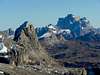
 Looking from Ciampei Pass towards Sassongher Looking from Ciampei Pass towards Sassongher |
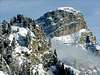
Sassongher is a fascinating mountain which towers about 1000m above the Ladinian town of Corvara in Alta Badia. It stands out from the Puez high plateau (also called Gerdenacia (in different spellngs) and commands great views of the neighbouring Sella- and Fanes-Groups. Sasshonger belongs to the Puez-Geisler Group and is located at its south eastern end.
The ascent to the summit is steep and strenuous and close to the top you need to climb a short ferrata, which is about 100m long and rather exposed. However, the ascent is rather easy and popular so that you have to be prepared to meet a lot of people on top.
Given the summit's central location within the Dolomites you can see most of the important Dolomite Groups in the distance from its top (Tofane-, Monte Pelmo-, Civetta-, Marmolada- and Langkofel- Groups
 |  |  |  |  |
Getting There
The following directions are from Marco Borello (marco979), who posted them on the Piz Boè page (Macro, I hope you don't mind):The nearest motorway exits are:
on the A22 (Brennero motorway) - Bolzano Nord
on the A27 motorway - Pian di Vedoia-Belluno.
From Belluno:
Drive along the S.P. 1 provincial road as far as Ponte nelle Alpi, turn into the S.S. 51 as far as Castello Lavazzo, and the 51 bis as far as Vodo di Cadore, in Pierosa enter the S.S. 48 to Andraz and eventually continue along the S.S. 244 to Corvara and the other localities of the Alta Badia.
From Venice and Treviso:
Drive along the A27 motorway to Belluno, exit Pian di Vedoia, turn into the S.S. 51 as far as Pierosa, and into the S.S. 48 as far as Andraz and eventually into the S.S. 244 to get to Corvara.
From Padova:
Drive along the A4 motorway, exit Mestre - Venice airport Marco Polo, and enter the A27 motorway, exit Pian di Vedoia. Continue to Corvara according to the directions from Belluno.
From Vicenza:
Drive along the A4 motorway, direction Brennero-Verona Nord, here enter the A22 motorway, via Verona, Trento and Bolzano, exit Bolzano Nord. Drive along the S.S. 12 as far as Waidbruck, and the S.S. 242 as far as Ortisei/St Ulrich and finally the S.S. 243 to get to Corvara.
From San Candido and Dobbiaco/Toblach:
Drive along the S.S. 49 as far as San Lorenzo di Sebato and then continue along the S.S. 244 to get to Alta Badia.
From Brunico:
Drive along the S.S. 242 to get to the localities of Alta Badia from Corvara to Colfosco/Kolfuschg
 |  |  |  |  |
Climbing Routes
Kletterwebbi provided me with the following information on two climbing routes up to Sassongher:S-face
Difficulty: UIAA 4,
Duration: 4h,
Altitude gain: 600m
First climbed: 1900 by G. Franzelin and J. Kostner
This route was done often in the past.
SO-ridge
Difficulty: UIAA 5-6
Duration: 6h
Altitude gain: 700m
First climbed: 1930 (?) by J. Hruschka, R. Oberhammer and J. Schalon
 |  |  |  |  |
Red Tape
There's no red tape to be found here. The summit is free to be climbed and I'm not aware of any parking fees at the trailheads of Colfosco/Kolfuschg or Corvarra. |  |  |
When To Climb
As with all Dolomite summits the best time is May through October but winter ascents are possible as well. | 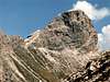 |  |  |  |
Accomodation
In general accomodation (hotels, appartments) can be found in all the villages in Alta Badia, Buchenstein, Fassa or Gröden. In addition there are a few campgrounds in the dolomites which in general are rather expensive and very much frequented. The nearest one is the one in Colfosco / Kolfuschg: Camping ColfoscoThe nearest refuge is the Rifugio Puez / Puez Hütte, which is situated on the edge of the Gardenachia plateau at the end of Vallunga/Langental some 1h30min away from Sassongher.
Mountain Conditions
For weather conditions in South Tyrol look at the page of Meteo Alpin. For the english text you have to scroll down the right frame. |  |
A Little Bit of History
Sassongher is situated in the heart of the Ladinian region of Italy. The Ladinians have a rather unique culture together with their own raethoromanic language. You will see all road signs in three languages: Italian, German and Ladinian. Over the centuries the Ladinans have been driven back (starting as early as in the Roman empire) into the most unaccessible valleys in the region. All four of them are grouped around the Sella massif: Val Gardena (Gröden), Alta Badia (Abtei), Fassa and Buchenstein. Politically the former belong to the autonomous region South Tyrol the latter to the automomous region Trento.The access to the Ladinian valleys leads to narrow gorges so that for a long time no one was able to reach the area in any other way than on foot. During World War I, in which the Dolomites were one of the most contested fronts several of the roads were created for supplying the troops. Thus Alta Badia was connected with the Pustertal in the north through the very narrow valley of Gaderbach, which is up to now one of the main access roads (see 'Getting There' section).
The actual front ran along the following line:
Kreuzbergpass, Tre Cime (Drei Zinnen), Monte Cristallo, Passo Falzarego, Marmolada (there the Austrians had a whole town beneath the glacier), Karerpass, Bolzano (Bozen). This - by the way - is almost the exact route of the 'Dolomitenstrasse' (Dolomites Road).
You can still visit quite a lot of World War I memorials, the nearest on Passo Pordoi, the most famous ones on Col di Lana (the summit of which the Italians exploded to root out the Austrian troops) and Monte Piano/Piana near the Tre Cime.
Needless to say that during the whole time that the war raged in the Dolomites no ground was won on either side.
My Personal Fascination with Sassongher
For me Sassongher is one of the most fascinating mountains that I know. It's not so much its height (at a mere 2625m) rather the different aspects that you get when you look at the summit from different directions. From Corvara it looks like a huge tower, from Gardenachia it's just a outpost of the huge plateau (much the same but still completely different to Moro Rock).And in 1996 on my climb to Sassongher pass I first started to overcome my acrophobia. I didn't reach the summit but from then on I planned to do the short ferrata. Needless to say that so far I haven't been able to revisit the mountain and now am able to do climbs much harder than the short exposed ascent to Sassongher.
In my Living room I have a copy of a large book (A3) with aerial pictures from South Tyrol. On the cover of that book is a perfect photography of Sassongher in the summer. If you ever have the chance to get a hold of the book - buy it, whatever the cost. It is called :
'Südtirol aus der Luft' by Jakob Tappeiner, ISBN: 3763410589
 |