Anticipating My First Climb of the Year
With negligible hiking or climbing experience in winter conditions, I hadn’t spent much time in the mountains for the past 7 months (besides for downhill skiing), and with the weather warming up I was excited for my first major climb of the year. A failed attempt on the Breithorn (one of the easier 4000 meter peaks in the Pennine Alps) a few weeks earlier due to adverse weather conditions had added to my pent-up frustration, so I was more eager than ever for my first summit of the season.
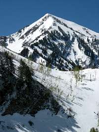
Just recently I got engaged, graduated from college at BYU, and started working full-time in Salt Lake City, so between wedding planning and adjusting to my first major job I would only have time for weekend hikes in the Wasatch mountains. I had previously hiked Mount Timpanogos and Mount Nebo, the range’s two most well-known mountains, but I did not have much knowledge of the Wasatch beyond that. I decided to search Summitpost for photos of other impressive mountains nearby, and this one in particular caught my eye:
![North aspect of Cascade...]() Photo of north side of Cascade Mountain by Marauders
Photo of north side of Cascade Mountain by Marauders![Fall colors in front of Cascade Mountain]() Fall colors below Cascade Mountain
Fall colors below Cascade Mountain
Although it just misses out on being a “Wasatch Elevener,” Cascade Mountain (10,908 ft.) appeared to be one of the more difficult mountains in the Wasatch, and its steep, rocky slopes seemed very appealing. From the descriptions I read it sounded like the south ridge (most non-technical route) would be doable for me and my fiancée Liz, who is an avid hiker as well. To shorten the distance to the summit by starting at the Dry Creek Trailhead instead of all the way down at the bottom of Rock Canyon, we would have to wait until the Squaw Peak road re-opened on Memorial Day.
The warm, sunny weather decided to go away for the weekend before Memorial Day, but there was only a slight chance of snow at the highest elevations of the Wasatch on Saturday and Sunday, so I was confident that the south ridge would still be snow-free when the sun came back out on Monday morning.
Fun in the Snow
![Freedom Peak, Southeast of Cascade Mountain]() Spring Snow
Spring Snow![Provo Peak Ridge]() Provo Peak ridgeline
Provo Peak ridgeline
We left Provo at 8 in the morning, and as the clouds around the mountain dispersed I discovered that there was actually a lot more snow than I had anticipated. This was the only time I’d have the entire day free for hiking in the immediate future though, so we decided that we should just get up there and see how things went before calling it off. Squaw Peak road changed from paved to dirt after a few miles, but it wasn’t as bumpy or rough as I was expecting. I had to slow down a bit on the steep section past Rock Canyon Campground, but my Camry handled it alright. ¾ of a mile past the campground I looked for the trailhead and saw a narrow trail leading off the road, with only a solitary wooden post next to it. Since this was the only trailhead I had heard of in this area, I assumed it was the Dry Creek Trailhead. We parked at the side of the narrow road, leaving space for other vehicles to pass, and began our hike at around 9 am.
![Fresh Snow Before Memorial Day]()
A few hundred feet after leaving the road, big patches of snow appeared, and I realized that we might not get very far before the trail became covered with white stuff. The views up towards Freedom Peak in front of us to the East and Provo Peak to the east were really amazing, and the bright green leaves on the aspen and pine trees around us provided a nice contrast to the snow covered peaks above. Sure enough, the trail disappeared about a mile later, and at this point we had to make our best guess as to which way the trail would have gone. We started hiking through the snow, and surprisingly the snow didn’t slow us down at all. It was only deep enough to get up to our shins in a few places, and as long as we made sure our footing was secure before moving on, it was actually pretty easy. My new Scarpa hiking/mountaineering boots were doing quite well at keeping my feet warm and dry, so I decided that we should go a bit further and enjoy the great views.
![Provo Peak from Dry Creek]() Provo Peak
Provo Peak![Freedom Peak]() Freedom Peak
Freedom Peak
As we got closer to the bottom of Freedom Peak the snow started to get a bit deeper and the slope steepened to about 40 degrees. I had read that inclines like this were very susceptible to avalanches (especially in the Wasatch, which receives quite a bit of snow throughout the winter), but since it was only a light dusting of snow and avalanche season was past I felt it was safe to keep going. I went first and made sure my prints were big enough for Liz to follow, since her boots didn’t work as well in the snow. Since we didn’t really know which way the trail would have gone or where the switchbacks were, we decided to turn left and head straight up towards the nearest spot on the south ridge (we were now heading north).
![Climbing up to the south ridge]() Liz scrambling up to the south ridge
Liz scrambling up to the south ridge
After going 1,000 feet straight up the steep slope, which was occasionally broken up by flat “terraces” (used to stop avalanches, I think), we reached the southeast ridge that connected with Freedom Peak and Provo Peak. This seemed to be the lowest point on the saddle connecting Cascade Mountain and Freedom Peak, and our view of Cascade’s main summit was still obscured by the southeast ridge. There were some big cornices off to our right, so we stayed a few dozen feet below the ridgeline (on the left [west] side, opposite the cornices) as we made our way along the southeast ridge. We followed one of the terraces below the ridgeline until we came to a steep snow slope of about 50 degrees. Looking down I saw that there were no terraces to break up the slope, which continued downwards uninterrupted towards Dry Creek over a thousand feet below us. Contemplating whether or not it was worth the risk, I started out across the slope, facing into the mountain making hard kick-steps into the snow and using my hands for support as I went, and before I knew it I was on the other side. As Liz started across behind me, doing her best to follow my footprints, I began to have second thoughts. I’d have felt terrible if my fiancée slipped and rocketed down the steep slope, so I told her to be extra careful. Thankfully she made it across without any problems, and we then scanned our surroundings to figure out where to go next.
![Steep Snow Slope]() Steep snow slope
Steep snow slope![Lots of Snow]()
Ahead of us was another steep slope, which had about a 60 degree incline. We had crossed the last one without any problems, but I didn’t want to risk going across a steeper one. At this point we decided to climb back up to the top of the ridge from where we were now, and if an easier path along the south ridge didn’t present itself then we would call it a day. I helped pull Liz up the last few feet of the steep, rocky incline (the terraced part in between the two steep slopes had some rocks and tree branches sticking out of the snow), and as we got on top of the ridge we were treated to a nice view of the clear sky to the east and the Uinta Mountains off in the distance. The cornices on this section were not as big as the ones we saw earlier on the south ridge, so going a bit farther wouldn’t be a problem. Our climb up those steep snow slopes had tired us out though, so we took a break by sitting on some dry boulders nearby and snacking on pop-tarts and granola bars. It was 12 o’clock and the sun was starting to beat down on us, so we put on some sunscreen to avoid getting burnt. The weather was great, and despite all of the snow surrounding us the temperature was probably in the mid 60’s, without much wind either. We took a long break (45 minutes) and admired the mountains around us before continuing.
![South Cascade behind the southeast ridge]()
![Start of South Ridge Climb]()
Liz had proven to be a better hiker than I thought, and I was proud of her for following me up a steep, snowy mountain when there were plenty of other things she could have been doing on Memorial Day. I didn’t plan on going much farther though, because she was starting to get tired. We continued on the ridge for a few dozen feet and then discovered a set of boot prints that had come up from the other (northeast) side of the ridge. Encouraged by the fact that there was at least one other person crazy enough to try climbing Cascade Mountain in the snow, we followed the footprints since they seemed to be tracing the easiest path along the south ridge. Eventually the main summit of Cascade Mountain came into view, and after following the holes in the snow a bit longer and traversing across some boulders, we got our first view of what awaited us on the remainder of the south ridge.
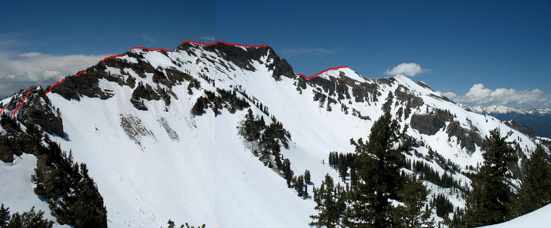
![]()
Panoramic view of the route I would take across the south ridge.
![Steep Scrambling]() Steep scrambling
Steep scrambling
The surrounding snow-capped peaks from this vantage point were amazing, but I was a bit discouraged by how far away the summit looked. From pictures on Summitpost, I recognized the south summit as the steep, rockier-looking peak on the left (which actually looked higher from where we were at) and the true summit as the one two to the right of the south summit with snow on it in the distance. This is probably when summit fever got a hold of me, because I started to rationalize that the distance wasn’t really that far and I’d probably be able to make it to the summit in a couple hours. We followed the ridge traverse for another hour, but Liz was slowing down and I could tell she needed another long break. I told her we could go back if she wanted, but she didn’t want to hold me back so she said I could continue on to the summit while she waited. Convincing myself that I wouldn’t be long, I told her I’d be back in 2 hours and set off at a slow jog towards the south summit.
![First Main Obstacle]()
![Utah Lake]()
About 300 feet along the ridge past where I left Liz, the tracks in the snow suddenly stopped and I was confronted with a steep rock wall on one side with a thick nest of pine trees and assorted plants blocking the path that led directly over the top. Whenever we had run across any smaller obstacles like this we had opted to descend a bit down the western side of the ridge to find a better path, since the east side of the ridge was generally steeper and had more cornices. I did so again, but this time had to descend quite far (at least a hundred feet) before finding a suitable route back up towards the ridge. After doing this once and hoping for a clear line towards the south summit afterwards, I discovered another impassable wall of trees at least 3 other times, and despite my fast pace it was taking longer than I had hoped, what with all of the backtracking and route-finding problems. The intermittent tracks I had been following had now stopped completely, which should have been a hint that if whoever had been here before (who likely had an ice axe and crampons, unlike me) had decided to turn back then I should as well, but I continued onward. Finally, after an hour and 15 minutes of scrambling through boulders, trees, and snow I arrived at the south summit at around 3:15 pm.
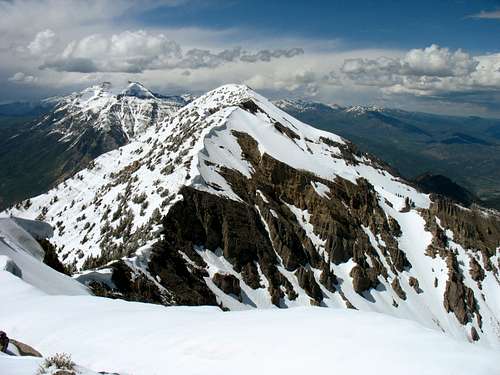
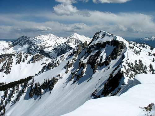
The views from the south summit were incredible. To the south I could see the long ridgeline I had just climbed up, with Shingle Mill Peak, Freedom Peak, and Provo Peak behind. Farther south and to the west a bit stood Mt. Nebo, the tallest mountain in the Wasatch. Directly to the west was Utah Valley, with the houses in Orem and Provo over 6,000 feet below. The steep southwest face of Mount Timpanogos, the most popular and photogenic mountain of the Wasatch range, was visible behind Cascade Mountain’s higher summit to the north. From here the rest of the south ridge looked much easier. Not being content to sign the register and head back down to Liz, I thought that if I ran faster I could get to the main summit in half an hour.
![South Ridge]() South Ridge
South Ridge![South Summit]() South Cascade Peak
South Cascade Peak
Even though I didn’t have crampons, my boots had proven to be quite capable in the snow, so I didn’t think twice about sliding down the steep slope (about 70 degrees) north of the south summit. I dug my elbows into the snow to slow my descent, and after sliding to a stop I continued jogging towards the main summit. Twenty minutes later I found myself at the top of a false summit (in between the north and south summits) though, and making a more reasonable calculation I guessed that it would probably take me another half hour from where I now was.
Turning Back
![Utah Lake below south summit]() Utah Lake
Utah Lake![Downtown Orem]() Orem 6,500 feet below
Orem 6,500 feet below
It was at this point that I made an important decision, which since then has helped me better prioritize other more important commitments than those of hiking and climbing. I had promised Liz I’d be back in 2 hours, and I had already been gone for an hour and a half. If I turned back now, I’d only be gone an hour longer than I told her, but if I continued then I wouldn’t be back for a whole 4 hours after leaving her. I started to feel guilty for dragging her along on what was supposed to have been a nice, enjoyable hike that instead had turned out to be my most difficult climb yet. Even though the summit was within reach and I had the energy to attain it, I finally gave in to my conscience and after taking a few pictures decided to turn around.
In my haste to get to the summit I had gone down a very steep snow slope (on the north side of Cascade Mountain’s south summit), and on my way back I realized that it would be much more difficult to get back the way I came. I tried kick-stepping up it as hard as I could, but on this shaded side the snow was much more hard and icy, and after three short trips up and three slides back down I ventured west onto a different part of the peak to try and find an easier way back. Eventually I found a spot where the incline was only about 50 degrees. The only problem was that a slide down this spot would lead to a drop off of Cascade Mountain’s western cliffs. Being as careful as possible to prevent this from happening, I slowly made my way back up to the top of the south summit, and once there I was able to retrace my steps through the snow back down the south ridge.
![West Slopes]() Looking towards North Cascade Peak ...
Looking towards North Cascade Peak ...![Cascade Main Summit from South Summit]() ... from South Cascade Peak
... from South Cascade Peak![Rock Canyon]() Not a good place to fall
Not a good place to fall![Steep Part]()
I finally made it back to where I had left Liz at around 5 pm, but she was nowhere to be found. She had probably gone back along the path we had followed for a more suitable place to rest (her original spot was very exposed to the wind), so I continued on, hoping that I would soon find her. Sure enough, I saw her huddled by a pile of rocks, shivering and trying to stay warm in the wind. A fresh surge of guilt went through me for seeing her so cold and uncomfortable, and I apologized for making her wait so long. She was understandably upset, but after we got moving and her limbs warmed up again she was in much better spirits. The sun was still as bright as ever, so we put on some more sunscreen. As we made our way back down the ridge the scenery was very different than it was earlier that day. The sun had already started melting through the snow in several places, and eventually we lost sight of the route we had taken to get up because all the snow around our tracks was gone. Looking down on Dry Creek I couldn’t even recognize where it was that we had gone up to get to the south ridge. There was one long strip of snow that extended most of the way down to Dry Creek (probably one of the steep snow slopes we encountered on our way up), and since the snow was now slushy instead of slippery and icy, we decided to go down that way. By this time it was past 6 pm, we were both tired from our long day in the snow and sun, and we were acting pretty goofy, singing and cracking jokes about all sorts of things as we slid down our little snow slide. It was fun.
![Footprints in the Snow]()
![East Slopes]()
The snow didn’t end in a very convenient place, so we had to down climb a steep gully and little waterfall. We followed a ravine towards where we thought the Dry Creek trail would be, and after a couple little falls (I banged my knee on a rock and Liz got some cuts on her arm) and a lot of bushwhacking we finally made it back onto the trail. From there it was another hour back to the trailhead, and we finally arrived back at the car at 8 pm. We got back to Provo just before it got dark and had a big dinner to restore some of the calories we had burned earlier in the day.
![Provo Peak and Cascade South Summit]() Looking at Cascade Mountain's south summit(right) and Provo Peak(middle) to the south.
Looking at Cascade Mountain's south summit(right) and Provo Peak(middle) to the south.![Snow Slide]() Snow slide
Snow slide
Climbing Cascade Mountain’s south ridge in the snow turned out to be the most memorable hike/climb I’ve ever been on. It wasn’t all fun (besides the blisters on my ankles from my new boots, we both were sunburnt pretty badly, and I couldn’t sleep the night after because my eyes hurt from being so burnt => I won’t forget glasses the next time I go hiking in the snow), but the views were to die for and it was a growing experience for both me and Liz (who’s now my wife). Although at the time I was disappointed for not making Cascade Mountain’s main summit, I learned that in some cases there are more important things than getting to the top. I discovered that on hikes and climbs I can get just as much if not more satisfaction out of the majestic views and the journey itself as I can from obtaining the summit. Looking back on the photos from our epic adventure brings back great memories, and ever since then I’ve loved taking pictures of the mountains. I’m also grateful to have a wife who supports me in my crazy endeavors (which I also discovered on this hike). Before our adventure on the south ridge I had aspirations to climb Mount Rainier, the Grand Teton, and some of the more difficult peaks in Colorado (Capitol Peak, Maroon Bells, Crestones), but now I'm happy to try easier peaks that Liz can enjoy as well. I have since discovered that there are plenty of challenging mountains in the Wasatch to keep me occupied, and it's great having access to such a wide selection of peaks so close to a major city.
![Cascade Mountain from Alpine Loop]() ... and the Alpine Loop.
... and the Alpine Loop.
Someday I may try climbing Cascade Mountain again (when the snow is gone), but for now I’m content to admire it as I drive down I-15 on my way to visit Liz’s family.
![Cascade Mountain from downtown Orem]() Cascade Mountain from Orem ...
Cascade Mountain from Orem ...![Cascade Moutain from the northeast in Provo Canyon]() ... Provo Canyon ...
... Provo Canyon ...Cascade Mountain Stats
DISTANCE:
12 miles roundtrip
DRY CREEK TRAILHEAD:
7,160 feet
SUMMIT ELEVATION (SOUTH PEAK):
10,761 feet
ELEVATION GAIN:
4,000 feet
DIFFICULTY:
Class 3
TIME:
11 hours


Comments
Post a Comment