How It Came to Be
My loving and adoring wife conceded this summer to a two week climbing vacation. The concession was that she would stay home, and I would go climbing. To add to the saintly nature of this gesture, I ended up climbing in the Wind River Mountains of central Wyoming. Now, you may not realize how grand this was of her until I give you a little background. I met my wife in Yellowstone where we both worked for many years. When we left the Park, we took a summer off to follow our dreams in the heart of the Wind River Range. We stayed for two months, climbing and hiking and being close to each other. The next year we were married at the Big Sandy Lodge, the beginning of our trail together.
The decision wasn’t all mine. My climbing partner and I tossed around all kinds of ideas about where to go. The Bugaboos. Northern Cascades. The Sierra. The Valley. The Winds had a balance of proximity, great rock, wilderness and fishing. Since he had never been, I let him choose the areas we should tackle. The Cirque of the Towers was the easy choice. But he also chose the East Fork Valley, a place close to my heart and my wife’s as well. That was the rub. I hadn’t been back there since we left in August of 1999. So that’s why she deserves so much credit for the success of this trip.
The Approach
Our trip began under ominous circumstances when I had to travel back East for a funeral and miss our planned first day. I flew from Alabama in the morning, picked up my stuff and we drove as far as Pinedale, WY that night, hoping to still be climbing by Monday. The guy working in The Outdoor Gear Shop where we got our fishing licenses didn’t help when he told us about being rained off of everything this summer. But we weren’t slowing down for talk of rain. We had to see this for ourselves! A pretty quick drive to the trailhead, an hour of packing and eight miles of hiking later we did. As we descended from Jackass Pass into the Cirque the bottom fell out and we had to run for cover. When we got a break, we hit the first campsite we found. Turns out, the east side of the Cirque is a much better place to camp than down in the middle of town. It wasn’t crowded, the site was great, the approaches were only about 10 minutes longer and we had a killer view of the towers around Cirque Lake. It was perfect.
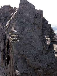
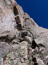
The weather was still a little shaky on Monday, so we hiked up to a small dome just north of the Watchtower to survey the place. Clouds kept moving through, but not really doing anything so it was on for Tuesday. After two trips to the Cirque, there was one route that really called to me; the North Face Right of Shark’s Nose. Since it was kind of short it made a perfect appetizer.
The Climbing - Part One
![Shark s Nose North Face, Right]()
We left pretty early, about 5:30 and it took about an hour to get to the Wolf’s Head/Overhanging Tower col. On the way we woke up some poor guy when a huge bull moose scared the hell out of both of us in the dark. Another hour and I was making the first thin moves onto the shaded face, chasing the sun above. The topo said five pitches, but we were on the summit in four. It was about three hours of climbing. Then Garrett missed a rap station and had to jug as a small, gutless squall moved in. Back at the start of the route we had some lunch and discussed what to do with the rest of our afternoon. We were looking across at Overhanging Tower and decided that looked good so we stopped along the traverse on the west side of the tower and started up the most difficult looking stuff we could find. Well, that turned out to be about 5.6, so we were on top in one long simul pitch. I think it took us an hour round trip, and we spent about 20 minutes on the summit. These things look so big from camp. I think we were back in camp by 5 pm after every climb we did.
![Shark s Nose North Face]()
![First day scoping the Cirque]()
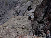
The next day broke cloudless and calm. About half way through the approach to the Northeast Face of Pingora, Gato stopped and started swearing. “I forgot the fucking camera! Shit! Dammit!” This continued for most of the day, and off and on for the rest of the trip. When we hit the base of the route, where I expected to get in line for this classic, I was amazed to be alone. In fact, no one else climbed that route on that day. We waited around for the first few rays of sunlight to hit the face before starting up.
For some reason I was suffering from some strange lethargy. I just couldn’t get into it. But I wasn’t going to let it slow us down too much. I struggled through the dihedral on the second pitch, but by my lead on the fourth I was at least able to climb. After that I even enjoyed myself. We lounged on the North summit for a little while, then rapped and walked over to tag the true summit before hitting the descent. At the top of the K-crack pitch on the South Buttress route we met our first people of the day. They let us ride their ropes, which is always such an appreciated courtesy. Many people complain of the crowding in these stellar climbing areas. But sometimes the camaraderie among mountaineers is worth the sharing. Besides, we had just finished a marvelously quiet ascent of 50 Classic that even the guidebook (printed in 1994) calls a crowded classic.
On the fourth day we rested. You see, we’re much faster than God (don’t take that too seriously). I was sitting on a rock with my small monocular trained on the Northeast Face of Warrior I, our next objective, while Gato read the beta. When he got to the part about belaying in a niche I saw something.
“Holy shit, there’s a dude up there.” It took us a while to find the other one because they were off route. After about an hour of watching them, we set off for a hike down to Lizard Head Meadows just to move around. Man, there were a lot of people on that trail. And one huge moose, too. As we neared the Cirque again, we were able to see the party on the Warrior start to rap the face. They seemed to be having trouble, and even had to climb back up one section to free a stuck rope.
Seeing the descent made the climb look much more mortal. Hell, if Fred Beckey could do it in the sixties . . .
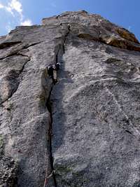
The Northeast Face of Warrior I was a definite highlight of our trip to the Cirque. The first two pitches were easy, but after that everything we did was 5.9. Some pretty thin face moves, a steep off-width, the solitary hand crack on the upper face, and a difficult corner. Eight pitches and we were on the small summit of the north gendarme. The guidebook spoke of a rotten chimney to the summit, but the climbing back to the rap stations didn’t look good and we left shoes at the base so the way down was clear.
The wind was out of control as we took summit photos and coiled ropes. The first throw got us about 30 feet. When I stopped to work the ropes a little, I moved a couple of enormous blocks that threatened to chop my line if I moved. I had to coil both cords, then move the blocks to safer ground, then throw again. This time the coils hung in the air for seconds before making a beeline due west around the corner. A strafing wind made it challenging to move the line through a rappel device. So we plodded to the bottom through six of these, pulling around corners on stuck ends trying to get enough slack to move down again. About the time we hit the deck the wind laid down. We rolled into camp with big smiles and a long afternoon to relax and work on finishing any food that didn’t need to be carried back to Big Sandy.
![NE Face Warrior I]()
![Gettin After It!]()
The plan was to hike out to the trailhead on Sunday, re-supply, and then start hiking back in towards the East Fork Valley the same day. But we realized that there was no way to really clean up ourselves or our gear at the car. That detail hadn’t been covered in our hurried preparation. In order to get enough time to drive to Pinedale, we decided to climb the East Ridge of Wolf’s Head Saturday morning, then hike out and drive to town for beer. Oh, and that other stuff, too. Foolproof.
There wasn’t much need to start before dawn, since we had been blazing up everything in sight, so we got to sleep in until six. Another leisurely breakfast to get rid of the last bit of food and coffee got us moving about an hour later. By this time, the hike over to Cirque Lake felt like walking to the garden from my back door. The climbing up to the start of the route had a couple of 4th class moves, but we were able to get just below the saddle before roping up. I did this route in 1999 and got some of the best pitches, so I told Gato to take the first pitch and make it good. He tied in to both ends of our one half rope, and I tied in to the middle. The rack was pretty slim, but we took 14 draws so we could simul long pitches without switching over too much. This tactic worked out pretty well, and three pitches and two hours later we were on the summit with the two guys we watched climb Warrior I. It was interesting comparing our different experiences on that climb, and we all descended together. Instead of hitting the normal route, we rapped down a gully southeast of the summit that put us above Cirque Lake, below the impressive South Face of Wolf’s Head. Those two had to go back to the start of the route and look for a missing cam, so we parted and tried to get psyched about the hike out to the trailhead.
Luckily we were only about 400 feet below Jackass Pass, so the uphill wasn’t too bad. But the Wind’s have a way of going up to go down, and down to go up. After a couple of hours of concentrated hiking we were at the car, listening to all the tunes that we had been singing (poorly, I might add) for the last week. For some reason both of us were stuck on Modest Mouse, so we listened to the ipod shuffle their songs the whole way to town, and the whole way back. As fate was guiding us, we hit the liquor store as they were closing, but they sold us beer anyway. Then we found a 24 hour laundry across the street from a small store and Subway (Pinedale, WY – All the Civilization You Need!). We made a few phone calls and took turns getting dinner and junk food while the clothes were in the wash. In all it took us two hours in town, and we were camped near the trailhead by about 11:30 that night. I was amazed.
The Climbing - Part Two
The next morning was an easy mix of coffee drinking, journal writing, packing and smoking. This allowed us to ease into the idea of hiking with a monster pack again. We had some pretty big objectives so we brought a pretty big rack. The idea was to take two days and fish our way up to Pyramid Lake, then climb Ambush Peak via the Golden Dihedral (Charlie Fowler classic), hike over Hailey Pass to Baptiste Lake and climb the West Buttress of Musembeah, then hike all the way out on our last day. There was but one rest day built in to this plan, but we were crushing routes, so it seemed ok at the time.
The fishing wasn’t as good as we hoped. We caught the hell out of fish. And if you were a 6” trout you’d better be afraid. Actually some of them weren’t that big. Our decision to bring the fly gear turned out to be the wrong one. The water was warm and the fish were deep and not very hungry. Didn’t really slow us down too much. We camped at Marm’s Lake the first night and yanked a few monster fry out of the lake. We had a great campsite, built a little fire and sat under the stars. It was great to be backpacking and fishing without the pressure (although still with all of the weight) of the climbing stuff. Sometimes it’s nice to just relax on your vacation. Apparently some people spend their whole vacation relaxing, but I don’t know these people.
Hiking in along this trail brought back a flood of memories for me. It was very emotional to think back on those first few steps that Jolee and I took towards a new life. We left Yellowstone, a place special to us for separate reasons, and set off into a new place that became special to us together. So when we arrived at Pyramid Lake on Tuesday, I took off by myself to wander around the campsite that she and I shared for most of that first month. I had spent the better part of two days thinking about that place, and I had spent over a week looking at my life in general. It’s pretty good, don’t get me wrong, but I still don’t feel as content as I used to. All of that, topped with the very recent death of my Grandfather just let loose at that spot, that one place that I remember so vividly, so fondly. I cried. It actually felt good. I wrote pages and pages in my journal, examining my connection to the mountains, and to the people I love. It was one of those powerful moments that tie people to their most important landmarks. It was spiritual (although I’m not religious), and it was refreshing. I felt vacated. Leaving there was much easier than it was eight years ago. This time I knew I would be back. And I will.
The next morning we were supposed to climb Ambush, but when the alarm went off we both decided we needed a rest day. It turned out to be a great decision. On Tuesday we hiked back down to Mae’s lake and fished the opposite shore with the same results. We found a couple of small, off trail lakes to hit on our way down to Skull Lake. There was only the same limited success. One of our dinners was a planned meal of trout and rice, but it was starting to look grim for any fish with even barely enough size to eat. Gato latched onto one, but for some reason he let it get off of the hook before he landed it. I’ll never figure that one out. We returned to Pyramid Lake (which was supposed to have Golden Trout, but had absolutely zero signs of fish) and packed for climbing again over another freeze-dried meal.
![Sea of Rock]()
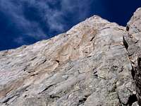
Wednesday morning we were able to get up for a climb. The hike over was pretty easy and mostly downhill from our camp. Only a couple of hundred feet of alarmingly loose talus (probably under snow most years) put us at the base of the Golden Dihedral. The feature is striking from across the valley, but it’s absolutely stunning from directly below. Like the Warrior, the first two pitches were easy. The real fun started on the third pitch, which entered the dihedral about half-way through. Gato took the first lead up the thing and got stuck, really stuck, in a nasty off-width roof thing.
![The Golden Dihedral]()
He ran out of gear at about 150 feet and built a pretty uncomfortable belay. I set off for the second half of the dihedral (I thought), and only made it about as far before I was out of draws, too. The exposure was intense but the rock was actually juggy, much unlike the Cirque, with incuts and face holds. But most of it was wide, reminding me of the Kor-Ingalls on Castleton Tower. The gear was mostly deep inside the crack, but you really didn’t want to go in there too much. I still managed to find plenty.
When Garrett started the sixth pitch we were still in the dihedral, and we weren’t done with it, really, until about half way through the seventh pitch. I topped out on a pedestal at the top of the namesake feature, climbed some exposed and exhilarating face to a sloping ledge that put me on a very small ledge, about 10 feet horizontally from a nice grassy ledge with about 5 feet of rope. I nestled one cheek on the ledge and let the other one air out over at least 1200 feet of rock and belayed Garrett up, then over to the grass. We were on pitch eight, but the description in the guidebook was talking about the 11th, angling left along ledges. The route just opened as long as you stayed close to the edge and sought out exposure. Where he ran out of rope was only 100 feet of easy climbing from the top. I think it was about 2:30 and all of those clouds that had been passing harmlessly over the last 10 days weren’t so harmless looking anymore. We hightailed it, taking a couple of “near summit” photos at the closest high point. But as we traversed under the main summit pyramid neither of us could resist. It’s only rain, right?
There wasn’t any lightning close, so we ran up and tagged the summit, our sixth of the trip. The rest of the descent was uneventful, save a little scree skiing on more terrain that has been under snow for a long time. That afternoon, sitting in camp thinking about the hike over Hailey Pass we made another startling discovery. Hiking over big passes with a heavy backpack sucks. So we bagged that idea and decided to spend the next day hiking to the base of Bonneville, at the head of the East Fork Valley just a few miles of easy hiking away. From Ambush we gazed on this pinnacled beauty at every belay. The routes were only Grade III and that was starting to sound pretty good.
Thursday morning we ran out of coffee. This was a disaster and will never happen again. But luckily the hiking was easy, and we made it easier by stashing some climbing gear, trash and clothes in one bear bag above our camp at Pyramid Lake. We made it up there in just a couple of hours and spent the rest of the day napping, casting fly lines into the fishless lake, and arguing about which spire was the actual summit of Bonneville. At some point in our titillating discussion the sky started to darken. We had seen this before and it was nothing to worry about. These things came and went but never really amounted to much rain, if any. After a couple of games of Yahtzee (I won) we had to jump in the tent because it really did rain. At least we were in bed early for an alpine start, right?
The alarm went off at five and I didn’t even say a word as I reset it for an hour later and went back to sleep, the steady drumming of drops on the fly easing me back to sleep. When it went off again at six to the same thing I didn’t even bother. We finally got up at about 7:30 and it wasn’t raining but the sky was ominous over the divide and looming worse over what we could see of the southern plains. The options weren’t looking to good. Our route was on the other side of the mountain, so if we set off and bailed, we would still have to hike back over a significant pass. At about 8:30 we made the decision to bail, packed up and started hiking at nine. At 9:30 it started to rain, slow at first, and then steadily turned into a driving rain.
When we got to our cache in the trees, both of us changed some clothes, ate a little food and talked about the plan. There was only one night left, we needed fish for dinner so we could hike down and camp at a lake and try our luck. But we both also knew that a night of rain would leave a bad taste. The call was made, we were out of there. Hiking out we were again cursing the nature of the trails. It seems no matter where you go in the Winds, you always cross about 10 drainages and climb both ways. As a consolation prize, the rain stopped about ¾ of a mile before the trailhead. Since we started pretty early, we made it to the car (and beer!) by 3:30. We stayed that night in Jackson with a friend and got plenty drunk before driving home to the wives.
Epilogue
I can’t imagine a bad trip to the Wind River Mountains. This one was incredible. We summited six peaks, five above 12,000 feet. We cruised Grade IV 5.9 twice and were only scared of one climb – The Feather Buttress on Warbonnet. A trip to any range is not complete without coming away with a haunting, future objective. Someday I’ll grow a pair and go up to the base of the Feather Buttress ready to man up. At least until then I have something to obsess about. Isn’t that what being a climber is all about?
Comments
No comments posted yet.