
-
 19034 Hits
-
 88.19% Score
-
 26 Votes
|
|
Area/Range |
|---|---|
|
|
51.27036°N / 115.17874°W |
|
|
Ice Climbing |
|
|
Winter |
|
|
Overview

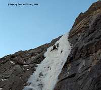
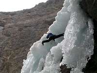
The Ghost was established in 1967 on the front range of the Canadian Rockies and consists of 15,317ha (60 square miles) of raw wilderness bordering Banff National Park to the east and north. Its mountains include Mounts Aylmer, Apparition, Oliver and Costigan. The Ghost Valley actually refers to a larger area that is more specifically located approximately 30kms north of Canmore along the eastern border of Banff National Park and east of the Palliser Mountain Range. The Ghost’s glacier carved valleys provide for steep water runoff creating some of the best waterfall ice climbing in Canada. Much of this terrain is considered less avalanche prone than most ice routes in Kananaskis and routes deeper into the national parks. Although not all the Ghost climbs are technically in The Ghost (many of the climbs are in Banff National Park), this whole area of provincial wilderness takes on that identity.

The Ghost Valley is discussed as the South Ghost and North Ghost relative to climbing. The South Ghost is divided into several different areas when discussing waterfall ice: Orient Point, Devil’s Gap, Planter’s Valley, Constellation Valley, Black Rock Mountain and Johnson Creek. The North Ghost includes all the climbs along both sides of the Ghost River. The “North Ghost” routes entail more of a 4x4 drive approach than the “South Ghost” routes.
Route Description(s)


The rated waterfall climbs in the South Ghost, meaning those specifically mentioned in Joe Josephson’s “Waterfall Ice, Climbs in the Canadian Rockies” are listed in order from south to north:
Orient Point
Planter’s Valley
Devil’s Gap
Constellation Valley
Black Rock Mountain
Johnson Creek
Getting There
From Calgary or Canmore, access 1A which parallels the TransCanada to the north. 13.4kms west of the Hwy 22 junction in Cochrane is the Forestry Trunk Road (Route 940). Turn north on the Forestry Trunk Road for 23kms to a gated gravel road on your left. There is a trail head information kiosk board here, but no obvious sign. If you find the gate closed, it is imperative that you close the gate behind you. Most climbers only take 4-wheel drive vehicles beyond this point, but depending on conditions, other vehicles can travel the road. This rough road goes for another 17kms until it reaches the “big hill”. Along the way there is one ice/water crossing. If this hill is muddy or icy or has too much snow, it can be extremely difficult to navigate. Orient Point’s “The Real Big Drip- 200m- V, M7+, WI 7” can be viewed to the southwest from atop this hill. This is a remote area and very little exists in the way of facilities or emergency help.Joe Josephson’s guide book, Waterfall Ice, Climbs in the Canadian Rockies- 4th edition, references turning left at the bottom of the “Big Hill” as you enter the Ghost River bottom. Present day (2007) you should turn right. Drive a short distance along the gravel bank before you come across a cairn and then descend the bank into the gravel wash. Follow the streambed to the east side of the dike and turn left and follow the dike for a short distance into some trees and cross to the west side heading for Devil’s Gap. The Banff National Park Boundary is well marked and you are not allowed to drive across it. Most of the ice in Devil’s Gap and thus the South Ghost can be accessed from this boundary spot. In the winter the Ghost Lakes are mostly dry icy mud flats that blow a ton of dust through Devil’s Gap. There are plentiful whitetail and mule deer en route to this area.
Red Tape
The important aspect of the Ghost regarding safety is that you are on your own. You are not always within the boundary of the National Parks and access can be difficult and long for rescue personnel. I highly advise you take a Satellite Phone (for communication with loved ones who might worry if you get stuck) and always be prepared to spend the evening (read sleeping bag, shovel, etc).There are no permit requirements to enter, climb and/or park in Alberta’s Provincial Parks. Cougars and Grizzlies can be more common place in the Ghost than the national parks due to its location on the front range. Take bear spray during non-hibernation months. This can be avalanche terrain during the winter. Therefore it would be prudent to check recent notices posted on the Canadian Avalanche Association’s website regarding that issue. However, the ice climbs in the Ghost are considered less avalanche prone than most routes throughout the National Parks and Kananaskis. The frequent Chinooks keep snow levels typically manageable in the Ghost.
Camping
There are no official campsites in the Ghost. Random backcountry camping is allowed, but open fires are prohibited in the Ghost River Wilderness Area. However, it appears that camp fires are quite tolerated by local visitors or even allowed in the Ghost River Valley around Devil’s Gap. More camping information can be found at this site.External Links
The Kananaskis Provincial Park website is a very thorough park website, including trail conditions or closures, wildlife notices, weather conditions, avalanche conditions, camping permits, whitewater conditions, etc. It is an excellent source if you are going to spend any time in the Ghost or surrounding area. Outside of the parks web sites, Canadian Avalanche Association is also useful, particularly for winter travel. Canadian Alpine Accident Reports are also extremely useful.Alberta’s Provincial Parks
DowClimbing.Com