
|
|
Route |
|---|---|
|
|
45.92140°N / 7.83910°E |
|
|
Summer |
|
|
One to two days |
|
|
Class 3 |
|
|
III° UIAA |
|
|
III |
|
|
Overview
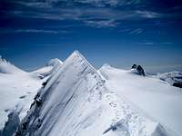
La cresta Sella è una bella salita piacevole e divertente. Se si rimane il più posibile sul filo, la roccia è, nel complesso, solida e sicura, ma le difficoltà aumentano. Il bel risalto di roccia fulva a metà sviluppo, se superato direttamente presenta passi di III°+ .
La salita all'Orientale per la cresta Sella e la successiva traversata all'Occidentale, sono forse la combinazione più varia e consigliabile per fare i Lyskamm.
Le difficoltà si trovano ad una quota superiore ai 4000m. L'orientazione a sud della Cresta Sella fa sì che la roccia sia spesso libera dal ghiaccio.
Sulle cresta nevose è sempre buona norma verificare la presenza di cornici.
South Ridge, called cresta Sella is a pleasant and enjoyable climbing. If you remain the more possibile on the wire, the rock are, overall, solid and safe, but it gets a bit harder. The beautiful red rock step at half way, if passed directly, presents a short pitch of III +.
Climbing Eastern Lyskamm by cresta Sella and the subsequent traverse to Western, maybe the best and recommended combination to make Lyskamm.
The difficulties are at an altitude above 4000m. The orientation to the south of south Ridge allow the rock is often free of ice.
On the snowy ridge is always a good thing to verify the presence of frames.
Getting There
Da Alagna Valsesia (VC - Italy)A26 > uscita Romagnano-Ghemme > SS299 Valsesia > Alagna

Da Alagna Valsesia prendiamo gli impianti di risalita per il Passo dei Salati formati da 2 tratti: la telecabina (primo tratto) fino a Pianalunga e poi la nuova funivia Funifor. E' utile sapere che dal Passo dei Salati, scendendo per pochi minuti e oltrepassato l'Istituto Mosso, si raggiungono il Rifugio Città di Vigevano e il Rifugio Guglielmina (Col d'Olen). Per proseguire, invece, verso la nostra meta, ci dirigiamo verso la stazione d'arrivo della telecabina che sale da Gressoney, e a destra prendiamo il ripido e pietroso sentiero che prosegue poi più in piano con un breve tratto attrezzato (corde fisse). Con un po' di saliscendi arriviamo alla base dello Stolenberg che raggiriamo, sul lato sinistro, grazie ad un tratto di sentiero attrezzato (corde fisse). A questo punto è ormai visibile la vecchia stazione di arrivo di Punta Indren. La raggiungiamo percorrendo una cresta di grosse lastre di pietra e un breve pendio di misto. Raggiunta Punta Indren il nostro cammino prosegue verso il Ghiacciaio di Indren percorrendo un tratto pietroso (variabile a seconda della stagione). Proseguiamo sulla battuta traccia che, praticamente in piano, attraversa il Ghiacciaio. Spesso, ad un certo punto, la traccia si divide in due: quella bassa e quella alta. Con quella bassa proseguiamo in piano fino al termine del Ghiacciaio, oltrepassiamo una pietraia, poi riprendiamo a salire e in breve arriviamo al Rifugio Città di Mantova.Da qui è visibile chiaramente la Capanna Gnifetti. La raggiungiamo seguendo la traccia che sale diritta, per poi deviare a sinistra. Pochi metri di sentiero attrezzato con pioli metallici e corde fisse e siamo sui gradini del terrazzo della Capanna Gnifetti 3647m. Se invece decidiamo di percorrere la traccia alta (da valutare a seconda della stagione e dello stato di innevamento), saliamo leggermente. Terminata la neve procediamo con un sentiero di misto (terra, pietre e neve) che dopo alcuni tornanti giunge alla base di un breve passaggio attrezzato. Corde fisse ed altro ci facilitano la salita di questo ripido tratto. Raggiungiamo la sommità di questo passaggio e vediamo a sinistra, più in basso, il Rifugio Città di Mantova e a destra, più in alto, la Capanna Gnifetti.

A26> exit Romagnano-Ghemme> SS299 Valsesia> Alagna
From Alagna Valsesia catch lifts to Passo dei Salati consist of 2 sections: the cable car (first part) to Pianalunga and then the new cable car Funifor. It 'good to know that from Passo Salati, down for a few minutes and passed the Institute Mosso, you reach the Rifugio Città di Vigevano and Refuge Guglielmina near Col d'Olen 2885m.
To proceed towards our destination, we go west for less than 100 meters, to the station of the cable that goes from Gressoney, and turn right following the steep and stony path (marked). In few minutes we reach the base of Stolenberg; than traverse on left side, go down for a little and reach the next Colle superiore delle Pisse (some fixed ropes along the way). Go further to the old arrival cable-station at Punta Indren (dismissed), walking along large slabs of stone and a short step slope. From Punta Indren our way continues through Indren glacier, first on a rocky stretch (variable depending on the season). We continue on the evident track, nearly flat, across the glacier. Almost at the end of the glacier the track is divided in two: one lower and one higher. Following the lower one, in half an hour we arrive at Città di Mantova Hut 3500m (2,30h from Salati Pass)

Now you can see Gnifetti Hut. Following the track go straight and then turn left. Few last meters of equipped path with metal steps and fixed ropes and you're on the terrace of Gnifetti Hut 3647m.(3,00h from Salati Pass).
Instead, if you decide to take the higher track (in reason of the season and state of snow), go up a little. Follow the marked path that go straight up, after a few bends take to the base of a short vertical passage (some fixed ropes facilities). At the top of this step we see on the left, below, Città di Mantova Hut 3500m and higher right Gnifetti Hut 3647m. Reach the track on the snow which comes from Città di Mantova Hut and in few minutes down to the same, or up to Gnifetti Hut.
Oppure da Gressoney (AO - Italy)
A8 Torino-Aosta uscita Pont S. Martin > SR44 > Gressoney > Staffal
Da Gressoney, località Staffal, prendiamo gli impianti di risalita per il Passo dei Salati. La prima telecabina raggiunge la stazione intermedia dell'Alpe Gabiet (1 bar-ristorante, Rifugio Gabiet) a pochi minuti dal Lago del Gabiet. La seconda telecabina raggiunge direttamente il Passo dei Salati. Da qui il nostro cammino prosegue come sopra descritto nell'accesso da Alagna Valsesia.
Even from Gressoney (AO - Italy)
A8 Turin-Aosta exit Pont S. Martin> SR44> Gressoney> Staffal
From Gressoney, Staffal, catch lifts to Passo Salati. The first cable car reaches the intermediate station dell'Alpe Gabiet (1 bar-restaurant, Refuge Gabiet) a few minutes from Lake Gabiet. The second cable directly to the Passo dei Salati. From here, our route continues as described above in access from Alagna Valsesia.
Altro comodo punto di appoggio è il rifugio Quintino Sella al Felik.
Il principale accesso al rifugio parte da Gressoney --> Staffal dove un servizio di impianti funiviari permette di raggiungere il Colle Bettaforca a 2.670m a circa 3 ore dal rifugio. E' possibile accedere al rifugio anche dalla adiacente valle di Ayas con tempi di acceso al rifugio più lunghi oppure usufruendo di un servizio di fuoristrada per raggiungere il colle Bettaforca.
Other good point of support is Quintino Sella Hut at Felik glacier.
The main approach to the hut start from Gressoney --> Staffal, where a service or cable railway can reach the Colle Bettaforca in 2670m to about 3 hours hiking from the hut. You can approach to hut from the adjacent valley Ayas with a longer route, or catching a service-road vehicles to reach the Colle Bettaforca.
Dal colle Bettaforca il sentiero è agevole e ben segnato tranne l'ultimo tratto di cresta che presenta alcuni tratti esposti ed è comunque attrezzato con corde fisse da usare come mancorrenti , fare attenzione in caso di neve o gelo.
Starting from colle Bettaforca the path is smooth and well marked; only the last part of the ridge has some exposed length, and is well equipped with fixed ropes, use caution in case of snow or frost.
Route Description
Salita :Dal rifugio Gnifetti salire lungo il classico itinerario per il Colle del Lys. A quota 4000, nei pressi del Colle Vincent, piegare a ovest verso il Naso del Lyskamm, il cui versante est permette di raggiungere per un ripido pendio nevoso (40°) il Passo del Naso (prestare attenzione nel superamento della crepaccia terminale)

Dal rif. Quintino Sella 3500m. dirigersi sul ghiacciaio del Felik verso NNE ed entrare nel bacino sup. del ghiacciaio del Lys occ. Con un ampio giro verso E , passando sotto i Lyskamm , arrivare alla base della rampa che conduce al passaggio del Naso (ca 2h). Calzati i ramponi salire il ripido pendio andando verso dx ( 150m. max 45° ghiaccio affiorante)e in ultimo traversare in leggera salita verso dx per raggiungere il passo del Naso a quota 4100m.(30 min.)
Discesa :
Da qui è possibile ridiscendere lungo la cresta est fino al Colle del Lys e di qui al Rifugio Gnifetti.
Si consiglia invece di proseguire lungo la cresta in direzione ovest (per lo più nevosa, con qualche facile passo su roccia) fino in vetta al Lyskamm Occidentale. La discesa da questa cima si svolge ancora lungo la cresta fino al Colle del Felik e da qui su pendii nevosi fino al Rifugio Quintino Sella.
From Gnifetti Hut with the classic route to Colle del Lys – Lysjoch reach altitude of about 4000m, near Colle Vincent. Turn west towards Naso del Lyskamm – Lyskamm’s Nose, whose eastern slope allow to reach a steep snowy slope (200m - 40 °) and than Passo del Naso – Nose’s Pass (be careful in overcoming bergschrund).
From here, follow the easy snowy flank that leads to the summit of Naso del Lyskamm – Lyskamm’s Nose, continue on the ridge, more and more exposed, next short descente to the Passo della Fronte – Front’s Pass (sometimes icy).
The ridge continues with mixed terrain (II°, climbing straitght on a red solid tower at half way offers a short pitch of III°+ ) to the last slope leading to the snowy east ridge. Follow it to west for a few tens of meters to the summit Lyskamm Eastern.
From Quintino Sella hut 3500m. to N on Felik glacier head NNE towards and enter to the higher basin of western Lys glacier. With a wide turn to E, passing under the southern Lyskamm flank, get to the base of the step leading to the Nose pass (ca 2h). With crampons climb the steep slope heading towards right (max 45 ° 150m. often icy ) and eventually cross on a slight slope towards the right passage to reach the Nose pass at 4100m altitude. (30 min.) Than like the route with approch from Gnifetti / Mantova Hut.
Descent:
From here you can descend along the east ridge to the Colle del Lys and than to the Gnifetti / Mantova Hut.

Instead is recommend continuing along the ridge to the west (mostly snow, with some easy step on the rock) to the summit of Lyskamm West (Lyskamm traverse). The descent from this peak follows the ridge to the Colle del Felik and than on Felik glacier to Rifugio Quintino Sella.