
-
 6004 Hits
-
 88.08% Score
-
 26 Votes
|
|
Route |
|---|---|
|
|
38.00400°N / 107.771°W |
|
|
Hiking, Mountaineering, Scrambling, Skiing |
|
|
Spring, Summer, Fall, Winter |
|
|
Most of a day |
|
|
Class 2 |
|
|
Overview
Cirque Mountain is a thirteener located in the Sneffels Range, part of San Juan Mountains. It lies east of Mount Sneffels, between Kismet and Teakettle. It is separated from Kismet by Dyke Col, which provides the access to the summit of Cirque.
The mountain is approached from beautiful Yankee Boy Basin, easily accessible by 4WD vehicles.
I inherited this page completely blank and the route was named by the original owner as South Slopes from Yankee Boy Basin. Robert F. Rosenbrough in his "The San Juan Mountains climbing and hiking guide" calls the same route West Ridge, which actually makes more sense. First you approach the Dyke Col from the south side, but later you ascend the West Ridge, which takes you to the summit. (the book is available on Amazon for 415$!!! It is out of print.). And Colorado Mountain Climb book calls the route Southwest Ridge - which combines the initial start via south slopes, and then continuation along the west ridge.
The first recorded ascent of this route was in July 1932. Williams, Griffith and Lavender made the first ascent of Kismet via its east ridge (from Dyke Col), and Cirque Mountain via its west ridge (also from Dyke Col).
Cirque Mountain is probably the easiest peak in the Sneffels range. The hike involves only class 2 walking. Cirque Mountain is not well views when looking from Yankee Boy Basin, you will first see Point 13,500, which you can easily by pass on your way towards the summit of Cirque Mountain.
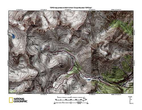 TOPO Cirque Mountain TOPO Cirque Mountain | 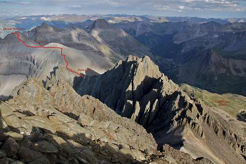 Overview of the route as seen from Mount Sneffels Overview of the route as seen from Mount Sneffels |
Getting There
From the town of Ouray, head south on US. 550, and turn right onto the Camp Bird Mine road. Cross the upper bridge over the Box Canyon at continue on the dirt road up Canyon Creek to a junction at 4.9 mile. Take the right fork (marked for Yankee Boy Basin), and head up Sneffels Creek to a parking area after 8.3 miles, at 11,350 feet. Note the road becomes progressively rougher as you proceed, and the drive to the parking area mentioned requires a four-wheel drive vehicle. There is a composting outhouse at the parking (= toilet trailhead). You can either park here, or continue further up the road if you have high clearance 4WD vehicle. Higher you go, rougher the road gets. You can opt to park at any chance you get per your comfort level of this road. I have driven all the way to the end, and if you want to make your outing as short as possible, continue until you get above the Wright's lake. Look for any pull out space and park.
I would like to mention that the road is very popular with jeeps and 4WD vehicles in the summer, and many companies based in Ouray operate trips into Yankee Boy Basin. Weekends can be pretty busy with traffic (and loud too). I prefer exploring this area off season or in the middle of the week. Also, the road is narrow at the higher sections and passing other vehicles is nearly impossible, so be prepared that you can get stuck in a traffic on summer weekends. Dyke Col is a popular spring back country skiing destination. Camp Bird Road is popular with ice climbing in the winter season.
 Scenic Road Scenic Road |  Lower Camp Bird road in winter Lower Camp Bird road in winter |  May conditions May conditions |  Winter snow shoeing Winter snow shoeing |  "Toilet Trailhead" "Toilet Trailhead" |
 Summer biking up Camp Bird Summer biking up Camp Bird |  Winter conditions again Winter conditions again |  Autumn scenery Autumn scenery |  Pulling sled into Yankee Boy Pulling sled into Yankee Boy |  Wright's Lake Wright's Lake |
Route Description
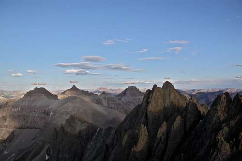
Nice evening view from Mt. Sneffels showing continuation of Sneffels range east - Kismet, Cirque Mountain, Teakettle, Cofeepot, and Potosi Peak.
Time: half a day in the summer, very long day in the winter (sometimes you need even two days in the winter time, the road is closed past Senator Gulch).
Difficulty: class 2, possibly a couple of class 3 moves below the summit
Description: There is no trail up to Dyky Col, but the grassy slopes offer easy hike/scramble up. It is not too steep and you can find grassy path avoiding the infamous San Juan scree. From Dyke Col there is a faint path with occasional small cairns. It is one of the few walk ups in the area. Point 13,500 is bypassed to the left (north). You will encounter a very short section of scrambling at 13,400 feet, just below the summit. The register is on the western summit. A long section of this hike is above 13,000 feet, so pay attention to weather changes. Enjoy. The route is pretty straight forward.
 Sarah Thompson on the summit Sarah Thompson on the summit |  Red Paintbrush in Yankee Boy Basin Red Paintbrush in Yankee Boy Basin |  Looking back - between Cirque and Dyke Col Looking back - between Cirque and Dyke Col |  Grassy slopes towards Dyke Col Grassy slopes towards Dyke Col |  Summit registry Summit registry |
Essential Gear
Comfortable hiking shoes, consider trekking poles. Rain gear during the summer thunderstorm season (July). Camera - the views of surrounding peaks are spectacular. Pet friendly.