
-
 8042 Hits
-
 85.36% Score
-
 20 Votes
|
|
Mountain/Rock |
|---|---|
|
|
48.12429°N / 113.91579°W |
|
|
Flathead |
|
|
Hiking, Mountaineering |
|
|
Spring, Summer, Fall, Winter |
|
|
6850 ft / 2088 m |
|
|
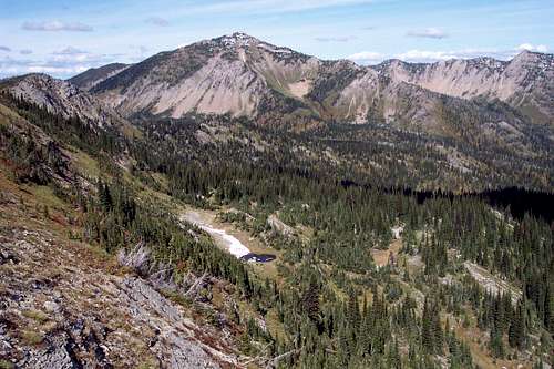
Overview of Squaw Ridge (Point 6850)
Layout designed for best viewing on a "1024 x 768" screen.

|
|---|
Looking to the mountain on the east side of the Flathead Valley there are many bumps along the skyline. One of these small highpoints along the skyline is Point 6948. Directly south of that point is another point on a ridge which stands at 6,850 feet above sea level. We have named that point Squaw Ridge.
There are no distinguishing features to garner an official name or for that matter an elevation mark on the map when cartographers placed lines marking elevations and the features that describe these few acres of land. More than likely just a few people have ever set foot on this ridge and its understandable unless incredible views and solitude are goals.
Evidently the grouse, mule deer and the other animals that call this place home like the open grass covered ridge as we saw plenty of evidence of their passing through.
The trip to Squaw Ridge is an enjoyable ridge walk and the views are perhaps some of the best in the Jewel Basin. From Squaw Ridge views into the Flathead Valley are unrivaled and unrestricted.
Getting There
 Squaw Ridge
Squaw Ridge is located on the western boundary of Montana’s Jewel Basin Hiking Area. This incredible area has been preserved for future generations by farsighted friends of the wilderness. Please see the Jewel Basin Area page for more details.
The Jewel Basin is open all year but due to massive amounts of snow the roads close sometime in late October to mid November and open again some time between the middle of June and the first week or so of July. During the winter season some backcountry enthusiasts snowmobile to the trailheads and either snowshoe or ski into the Jewel Basin. Please keep in mind motorized vehicles including snowmobiles, motorbikes, four wheelers and even mountain bikes are prohibited in the Jewel Basin.
The Jewel Basin is also closed to pack stock, horses and all dogs must be on a leash.
The USFS has published an on-line Map of the Jewel Basin.
Red Tape
 Squaw Ridge Route
There is little red tape with the exception of a 12 person maximum group size on all trips.
There is a strict "Leave No Trace" policy here as should be expected. Stay on designated trails.
Follow all guidelines for camping in bear country if you plan to camp as black bear and grizzly bear call this area their home. There are also mountain lions in this area.
As with all hiking and climbing in Northwestern Montana use caution and practice good manners with the wildlife. You are in bear country. Carry bear deterrent spray, don’t hike alone and make some noise.
For more information please go to the Glacier National Park's website for Bear Information. The U.S. Forest Service also has helpful information on Grizzly Bear Management.
Route Information
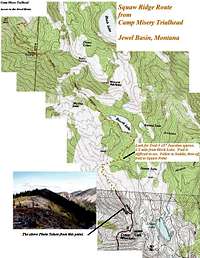
Directions to the trailhead:Please visit the Camp Misery Trailhead information for directions to the start of the route.
On Trail Directions:
Upon arriving at Camp Misery take a quick look at the map that is posted on the Information Board and take off up the Jeep Road to the right of the sign that is next to the gated road. Follow that road through a few switchbacks until breaking up onto the ridge above Camp Misery. An interesting side trip can be had by following a trail that takes off to the right. It goes up to a knob and there are nice views there. Continue on the road for another ½ mile or so where you will find another enlarged parking area. Back in the 1970’s we could drive to this point, since then the US Forest Service has closed this road hence the gate at the bottom of the road.
 The Correct Trail
By looking south the foot trail will be seen. Follow that trail to a junction. There are actually 5 trails that meet at this junction. From the trail you are on take the second trail. The sign says Birch Lake. Do not take the Switchback Trail which heads off below the trail you just walked.
 Alpine Trail # 7
Walk on Alpine Trail #7 to Birch Lake. While en-route Martha Lake can be seen below the trail and Point 6948 (Birch Peak) can be seen above Martha Lake.
Upon reaching Birch Lake take a quick break and then cross the log bridges at the outlet of the lake. Continue on Alpine Trail #7 for another mile until reaching the next junction with trail #187. This junction is difficult to see but the trail is obvious. Take a right turn and follow this trail to the saddle between Birch Peak and Squaw Ridge. A few extra yards of walking will reward you with views of the Flathead Valley, but there are better views on the ridge.
 Beginning the Off Trail Portion
Off Trail Directions:
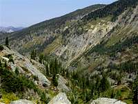
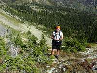
When reaching the saddle the route to Squaw Ridge continues south off trail. We found it easiest to head up the ridge just before reaching the saddle. After just a few yards we located a descent game trail which in turn helped us skirt the slabs of rock on the north end of the ridge.
Upon reaching the ridge it is an uncomplicated enjoyable walk to the top of this ridge.
Special Considerations:
The rock in Northwestern Montana is widely varied and it is not unusual to find several different types of rock on any given route. Know your rocks and be certain of your safety. J. Gordon Edwards has an excellent section in his guidebook, A Climber's Guide To Glacier National Park, on rock and climbing safety. Be safe and know your limitations as well as those who are climbing with you. Also refer to the following links for further details: GNP Rock and Grading System and the GMS Climbing Guidelines.
When to Climb and Weather

|
|---|
This climb can be done at any time of the year. If the preference is for no snow plan on doing Squaw Ridge anytime between June 15th and the end of October.
Montana gets its share of interesting weather. In June of 2008 we had over 2” of snow in the Flathead Valley and up to 24” inches of new snow in the high country.
In Montana it is said “If you don't like the weather just wait a half hour” or you can check out what’s up with the local weather at Flathead Valley Weather.
Equipment and Camping
The Flathead Valley

Equipment:
◊ Bear Spray
◊ Hiking Poles
◊ Water
◊ Camera
◊ GPS (for those who are navigation impaired)
◊ Hiking boots
◊ Sun screen
◊ Fishing Pole and Montana Fishing License
Camping
The nearest Campground is located at Birch Lake. There is a pit toilet there as well. It is located on the north end of the lake about 200 yards from the trail. A use trail leads to the outhouse. If away from the outhouse the USFS requires that a cathole be used and be located at least 200 feet from water.
A permit is not needed to camp within The Jewel Basin. When choosing a campsite find one away from trails, meadows, lakes and streams to reduce your impact on fragile areas. “Leave No Trace” camping and hiking needs to be observed. Do not cut switchbacks and remember to “Pack It In - Pack It Out”
Campfires are permitted in the Jewel Basin but please use a lightweight camp stove instead. No open campfires are allowed within 500 feet of Birch, Crater, Twin and Picnic Lakes, to prevent further damage around the lake shores. External Links
![Squaw Ridge (Point 6850)]() June 2009 Photo
June 2009 Photo
Visit Montana
Map of the Jewel Basin
Fishing article by John Fraley of MTFWP
Flathead County Search and Rescue
USFS official Jewel Basin Site

|
|---|
The nearest Campground is located at Birch Lake. There is a pit toilet there as well. It is located on the north end of the lake about 200 yards from the trail. A use trail leads to the outhouse. If away from the outhouse the USFS requires that a cathole be used and be located at least 200 feet from water.
A permit is not needed to camp within The Jewel Basin. When choosing a campsite find one away from trails, meadows, lakes and streams to reduce your impact on fragile areas. “Leave No Trace” camping and hiking needs to be observed. Do not cut switchbacks and remember to “Pack It In - Pack It Out”
Campfires are permitted in the Jewel Basin but please use a lightweight camp stove instead. No open campfires are allowed within 500 feet of Birch, Crater, Twin and Picnic Lakes, to prevent further damage around the lake shores.
External Links
 June 2009 Photo
Visit Montana
Map of the Jewel Basin
Fishing article by John Fraley of MTFWP
Flathead County Search and Rescue
USFS official Jewel Basin Site